Scottish Local Council Electoral Wards – General, Geographic & Electoral Knowledge Atlas (16 May 2020)
![]() NEW FOR THIS EDITION – Updated for the local by-elections that have occured since the last edition of this map was published on 25 Jan 2020. Quite a few of elections were scheduled from March to mid May, however only the earliest one took place as planned before the Coronoavirus Crisis caused the postponement of the others. The re-scheduled dates (where set) are in October & November this year, but it will depend on the public health guidance issued by the Scottish Government closer to the time as to whether they will go ahead as planned. Either way, we anticipate that it will be a wee while before we publish another update of this map.
NEW FOR THIS EDITION – Updated for the local by-elections that have occured since the last edition of this map was published on 25 Jan 2020. Quite a few of elections were scheduled from March to mid May, however only the earliest one took place as planned before the Coronoavirus Crisis caused the postponement of the others. The re-scheduled dates (where set) are in October & November this year, but it will depend on the public health guidance issued by the Scottish Government closer to the time as to whether they will go ahead as planned. Either way, we anticipate that it will be a wee while before we publish another update of this map.
There are 354 Electoral Wards in Scotland’s 32 Local Councils, to which 3 or 4 local councillors are elected every 5 years (the last Scottish National Local Election was 4th May 2017). Obviously this is a political process with an unpredictable outcome, but this map is about connecting the general, geographic & electoral knowledge resources about electoral wards that remain valid no matter who is currently elected.
So building on the base framework of Local Council knowledge seed branches provided by our Scottish Local Councils General & Geographic Knowledge Atlas (19 Sep 2019), we have added a collection knowledge seed branch for all the wards in each council as a whole, with sub-branches of seed branches for each individual ward. Embedded within each of these is a high resolution thumbnail image of the official ward boundary map, as well as contextual ‘facts & figures’ such as geographic area and population – as well as some we’ve calculated ourselves using rudementary spatial analysis – in the form of data fields. Calculations for ‘Area Per Councillor’ or ‘Population Per Councillor’ – at whole council and individual ward level – make for interesting comparison, and as far as we know, are not available anywhere else in the public domain.
Also attached to all seed branches is a variety of index markers that tag them with some of the contextual knowledge and enable dynamic filtering to hide / show map content as well as aid internal navigation.
Collections of sub-branch links to general, geographic & electoral knowledge resources about each individual ward, and the all the wards in each council as a whole – with the most essential of these attached to each seed branch – complete this updated edition of our first national knowledge map of every Local Council Electoral Ward in Scotland. Like the Local Council atlas, it establishes a comprehensive & robust visual knowledge framework upon which we can build many other maps about the ‘national local’ building blocks of Scotland based on Local Council Electoral Ward Areas in the future.
![]() NEW FOR THIS EDITION – Updated for the local by-elections that have occured since the last edition of this map was published on 25 Jan 2020. Quite a few of elections were scheduled from March to mid May, however only the earliest one took place as planned before the Coronoavirus Crisis caused the postponement of the others. The re-scheduled dates (where set) are in October & November this year, but it will depend on the public health guidance issued by the Scottish Government closer to the time as to whether they will go ahead as planned. Either way, we anticipate that it will be a wee while before we publish another update of this map.
NEW FOR THIS EDITION – Updated for the local by-elections that have occured since the last edition of this map was published on 25 Jan 2020. Quite a few of elections were scheduled from March to mid May, however only the earliest one took place as planned before the Coronoavirus Crisis caused the postponement of the others. The re-scheduled dates (where set) are in October & November this year, but it will depend on the public health guidance issued by the Scottish Government closer to the time as to whether they will go ahead as planned. Either way, we anticipate that it will be a wee while before we publish another update of this map.
Our Scottish Local Council Electoral Wards – General, Geographic & Electoral Knowledge Atlas is the ideal starting point for ‘thumb & brain friendly’ desktop (or even ‘in the field’) research for anyone with an interest in any, or all, of Scotland’s 354 Local Council Electoral Wards. It is made up of a visual framework of…
![]() 32 Scottish Local Council general knowledge seed branches – with unique identifying codes, embedded logo & thumbnail location map image and contextual general ‘facts & figures’ such as geographic area and population as single data fields, as well as attached multiple hyperlinks to core general & geographic knowledge resources, and index markers that also tag them with some of the contextual knowledge.
32 Scottish Local Council general knowledge seed branches – with unique identifying codes, embedded logo & thumbnail location map image and contextual general ‘facts & figures’ such as geographic area and population as single data fields, as well as attached multiple hyperlinks to core general & geographic knowledge resources, and index markers that also tag them with some of the contextual knowledge.
![]() 32 Local Council Electoral Wards as a Whole general knowledge seed branches – with embedded thumbnail ward overview map image, contextual general ‘facts & figures’ about wards as a whole such as geographic area and population per councillor as single data fields, as well as attached multiple hyperlinks to core general, geographic & electoral knowledge resources.
32 Local Council Electoral Wards as a Whole general knowledge seed branches – with embedded thumbnail ward overview map image, contextual general ‘facts & figures’ about wards as a whole such as geographic area and population per councillor as single data fields, as well as attached multiple hyperlinks to core general, geographic & electoral knowledge resources.
![]() 354 Local Council Electoral Ward general knowledge seed branches – with unique identifying codes, embedded thumbnail location map image, contextual general ‘facts & figures’ such as area and population per councillor as single data fields, as well as attached multiple hyperlinks to core general, geographic & electoral knowledge resources and index markers that also tag them with some of that contextual knowledge.
354 Local Council Electoral Ward general knowledge seed branches – with unique identifying codes, embedded thumbnail location map image, contextual general ‘facts & figures’ such as area and population per councillor as single data fields, as well as attached multiple hyperlinks to core general, geographic & electoral knowledge resources and index markers that also tag them with some of that contextual knowledge.
Each of these individual ward seed branches also has collections of sub-branches, each with a single hyperlink to official / definitive / plain old useful General, Geographic or Electoral knowledge resources about it found in the public domian…
![]() General Knowledge Resource Link Collection – This includes the local council’s website ‘Ward’ page(s) (if present), Councillors by Ward’ page (general ‘Councillors’ page if not present) & Individual ward profiles (if present), and the ward profile on the Scottish Government Statistics Portal.
General Knowledge Resource Link Collection – This includes the local council’s website ‘Ward’ page(s) (if present), Councillors by Ward’ page (general ‘Councillors’ page if not present) & Individual ward profiles (if present), and the ward profile on the Scottish Government Statistics Portal.
![]() Geographic Knowledge Resource Link Collection – This includes the local council’s website static or interactive viewer ward maps (if they have them), the Local Government Boundary Commission for Scotland Council Boundary Review, and Ward Boundary Map.
Geographic Knowledge Resource Link Collection – This includes the local council’s website static or interactive viewer ward maps (if they have them), the Local Government Boundary Commission for Scotland Council Boundary Review, and Ward Boundary Map.
![]() Electoral Knowledge Resource Link Collection – This includes the local council’s website election results pages (not always linkable to at individual ward level), the 2017 Scottish Council Election results at overall council and individual ward level on Professor Denis Mollison’s minisite & Wikipedia, and crowd-sourced details of all the candidates that have stood in elections & by-elections in each UK Local Council Ward since 2016 on the Who Can I Vote For? by Democracy Club website.
Electoral Knowledge Resource Link Collection – This includes the local council’s website election results pages (not always linkable to at individual ward level), the 2017 Scottish Council Election results at overall council and individual ward level on Professor Denis Mollison’s minisite & Wikipedia, and crowd-sourced details of all the candidates that have stood in elections & by-elections in each UK Local Council Ward since 2016 on the Who Can I Vote For? by Democracy Club website.
Together these elements establish a comprehensive & robust visual knowledge framework upon which we can build many other maps about the ‘national local’ building blocks of Scotland based on Local Council Electoral Ward Areas in the future.
![]() MindManager Users – As with all our maps, the MindManager (.mmap) version of this map is also both a base map to add your own content to, or a source of content that can be added to your own existing maps.
MindManager Users – As with all our maps, the MindManager (.mmap) version of this map is also both a base map to add your own content to, or a source of content that can be added to your own existing maps.
Explore the other tabs for comprehensive descriptions of the knowledge seed branches and knowledge link collections that make up this knowledge atlas map….
- 4,968 Map branches, containing...
- 6,514 Hyperlinks to official / definitive / plain old useful public domain knowledge resources, about the...
- 32 Scottish Local Councils, and their...
- 354 Multi-member Electoral Wards
Part of the 'Governance & Politics' Category
Anybody can view and download the HTML version of this map for free…
- View the HTML map – which will open as a standalone, full-screen webpage in a new browser tab, using the ‘View HTML map full screen’ button below.
- Download the HTML map file – for viewing on – or off – line in any modern browser, on any device, without additional plugins – using the ‘Download HTML map’ button below. Note you will need to be a basic member and be logged in to the site (registration for basic membership is free 🙂 ).
To download the MindManager (.mmap) map file – for amending, adapting & repurposing in MindManager software – you will need PRO membership, available for a modest annual, or one off lifetime, fee.
Already joined? Login here.
Download MindManager (.mmap) Map [16.2 MB]
Knowledge seed branches provide a ‘base level’ of contextual knowledge about the subject embedded within, or attached to, them in the form of…
![]() Image [Embedded] – Such as thumbnail location maps, flags, icons, people profile pictures etc., which provide a unique visual element that users can instantly latch on to as they navigate their way through the map.
Image [Embedded] – Such as thumbnail location maps, flags, icons, people profile pictures etc., which provide a unique visual element that users can instantly latch on to as they navigate their way through the map.
![]() Text [Embedded] – Rich (ie. variably formatted) branch text – such as names & unique identifying codes (taken from official sources) – is a unique MindManager feature.
Text [Embedded] – Rich (ie. variably formatted) branch text – such as names & unique identifying codes (taken from official sources) – is a unique MindManager feature.
![]() Note [Attached] – Contains supplementary information with all the elements of a word processed page – variably formatted (‘rich’) text, tables and images.
Note [Attached] – Contains supplementary information with all the elements of a word processed page – variably formatted (‘rich’) text, tables and images.
![]()
![]() Spreadsheet Table / Chart [Embedded] – Containing contextual facts & figures, which can be toggled between table and chart view as appropriate (once again unique to MindManager).
Spreadsheet Table / Chart [Embedded] – Containing contextual facts & figures, which can be toggled between table and chart view as appropriate (once again unique to MindManager).
![]() Multiple Single Data Fields [Embedded] – Another way of adding contextual facts & figures to the map (once again unique to MindManager), these are like single cells in a spreadsheet and the values can be used to format the topic.
Multiple Single Data Fields [Embedded] – Another way of adding contextual facts & figures to the map (once again unique to MindManager), these are like single cells in a spreadsheet and the values can be used to format the topic.
![]() Index Marker Tags [Attached] – Arranged in groups and added to individual branches as appropriate, tags add contextual knowledge, enable map filtering and navigation.
Index Marker Tags [Attached] – Arranged in groups and added to individual branches as appropriate, tags add contextual knowledge, enable map filtering and navigation.
![]() Multiple Hyperlinks [Attached] – Another unique feature, multiple links to a range of official definitive / plain old useful knowledge resources about the subject of the seed branch – usually selected from the full range of general & geographic knowledge resource collections – help turn the map into a knowledge portal without adding to the visual clutter.
Multiple Hyperlinks [Attached] – Another unique feature, multiple links to a range of official definitive / plain old useful knowledge resources about the subject of the seed branch – usually selected from the full range of general & geographic knowledge resource collections – help turn the map into a knowledge portal without adding to the visual clutter.
All the seed branches and their associated embedded / attached contextual knowledge elements used in this map are described in detail below…
Scottish Local Council Knowledge Seed Branch

Scottish Local Councils Knowledge Seed Branch
![]()
![]() Branch Outline Shape
Branch Outline Shape ![]()
![]() Image
Image ![]()
![]() Text
Text ![]()
![]() Embedded Data Fields
Embedded Data Fields ![]()
![]() Index Marker Tags & Goups
Index Marker Tags & Goups ![]()
![]() Attached Hyperlinks
Attached Hyperlinks
MindManager provides an unparalleled range of ‘information cartography’ functionality that enables contextual knowledge to be embedded and attached to map branches in multiple ways…
.
![]()
![]() Branch Outline Shape
Branch Outline Shape
For geographic area seed branches the outline shape indicates the nature of it’s borders with it’s equivelant neighbours…
![]() CIRCLE = all coastal borders (ie. ‘island(s)’)
CIRCLE = all coastal borders (ie. ‘island(s)’)
![]() HEXAGON = all land borders (ie. ‘land-locked’)
HEXAGON = all land borders (ie. ‘land-locked’)
![]() ROUNDED RECTANGLE = mixed coastal & Land borders
ROUNDED RECTANGLE = mixed coastal & Land borders
Note(s)
i) Assignment of shapes to geographic area seed branches is controlled by MindManager’s unique Smart Rule feature using the ‘SLC – Borders Types’ tag (eqivelant to thematic mapping in GIS).
.
![]()
![]() Image: Council Logo & Thumbnail Location Map
Image: Council Logo & Thumbnail Location Map
MindManager allows a single image to be embedded within a branch, which may be sufficient for the requirements. However with a bit of forethought (and some software ‘jiggery pokery’ 🙂 ) we can also create one that incorporates more than one visual element so that, like the ‘rich’ branch text, more core knowledge can be ‘packed in’ to a single branch without visually overwhelming the user.
![]() ‘Thumbnail’ Council Location Map – The thumbnail ‘boundaries only’ map (which has been created by us) shows the council area within Scotland.
‘Thumbnail’ Council Location Map – The thumbnail ‘boundaries only’ map (which has been created by us) shows the council area within Scotland.
![]() Council Logo – Incorporating council logos into map branches makes for swifter navigation and improved user experience.
Council Logo – Incorporating council logos into map branches makes for swifter navigation and improved user experience.
Note(s)
i) All images are optimised to reduce the file size.
ii) Due to the disparate nature of the size of the geographic areas of Scottish Local Councils, locations are not always immediately obvious for the smallest ones. If you zoom in on-screen, all will become clear though!
.
![]()
![]() Text: Official Name & Unique Identifying Codes
Text: Official Name & Unique Identifying Codes
Thanks to MindManager’s unique ability to handle ‘rich’ text – the ability to variably format individual chatracters within a single text ‘string’ – we can pack several different pieces of ‘core knowledge’ into the text of a single branch without it visually overwhelming the user.
Note(s)
i) All names and codes are meticulously sourced from official sources to ensure unambiguous identification of the council body and easy cross-referencing with other data sources, especially GIS databases (though it’s still not without it’s contradictions – see below!).
![]() Council Name – We have taken the names of the Council from their own website, with the proviso that…
Council Name – We have taken the names of the Council from their own website, with the proviso that…
- The geographic reference in the name comes first for ease of alphabetic referencing, with any of the ‘extra terms’ named below inserted after.
- For names in Gaelic we have added an english language translation in square brackets afterwards e.g. Eilean Siar, Comhairle nan [Western Isles, Council of the].
Note(s)
i) The names of some councils can vary between official sources, especially if they include the following terms…
- ‘The’ – The definite article – should it be filed under ‘T’? In our map ‘The Highland Council’ is listed as ‘Highland Council, The’
- ‘And’ – Is it ‘Dumfries and Galloway’ as you would say it, or is it ‘Dumfries & Galloway’ as it is written in their logo? In our map it is always listed as ‘Dumfries and Galloway Council’
- ‘City’ – It’s either ‘City of ….’ or ‘… City’. For example ‘Glasgow City Council’ is usually listed under ‘G’ (as it is on our map), but we have seen it as ‘City of Glasgow’ under ‘C’. ‘The City of Edinburgh Council’ is a double dilemma, but we’ve gone for ‘Edinburgh Council, The City of’, but it’ can be listed under ‘C’ or ‘T’ in some official sources.
![]() Council Type – SLC = Scottish Local Council.
Council Type – SLC = Scottish Local Council.
This applies to all Local Councils in Scotland, which all operate in the same way. In a whole-UK context they are classed as ‘Unitary Authorities‘, which is only one type of local council…
- ‘County Councils (Shires)’ with subordinate ‘District Councils’
- ‘Metropolitan County Councils’ (now abolished) with subordinate ‘Metropolitan Borough Councils’
- ‘Unitary Authorities’ and ‘Metropolitan Boroughs’
![]() ISO3166-2 code – ISO 3166-2 is part of the international standard ISO 3166 ‘Codes for the representation of names of countries and their subdivisions’. In Scotland the ‘principal subdivisions’ are Local Council Areas, so the ISO 3166-2 code is an additional, internationally recognised, unique identifier for each Local Council.
ISO3166-2 code – ISO 3166-2 is part of the international standard ISO 3166 ‘Codes for the representation of names of countries and their subdivisions’. In Scotland the ‘principal subdivisions’ are Local Council Areas, so the ISO 3166-2 code is an additional, internationally recognised, unique identifier for each Local Council.
![]() ONS Code – The UK Government Office for National Statistics – in partnership with the devolved governments – maintain a series of codes to uniquely represent a wide range of geographical areas of the UK (such as Council Areas and Electoral wards), for use in tabulating census and other statistical data, known as ‘ONS codes‘ or ‘GSS (Government Statistical Service) codes’.
ONS Code – The UK Government Office for National Statistics – in partnership with the devolved governments – maintain a series of codes to uniquely represent a wide range of geographical areas of the UK (such as Council Areas and Electoral wards), for use in tabulating census and other statistical data, known as ‘ONS codes‘ or ‘GSS (Government Statistical Service) codes’.
Although the codes are not formally hierarchical like the previous system it replaced, ONS codes for the same type of geographic area start with the same 3 characters…
- S12 = Unitary Authority
- S13 = Ward or Electoral Division
- S14 = Westminster Parliamentary Constituency
- S15 = European Electoral Region
- S16 = Scottish Parliament Constituency
- S17 = Scottish Parliament Electoral Region
- S21 = National Park
- S22 = Travel to Work Area
- S23 = Police Force Area
- S34 = Workplace Zone
- S92 = Country
![]() EU NUTS code – The European Union Statistics Agency (Eurostat) maintains a list of ‘Nomenclature of Territorial Units for Statistics (NUTS)‘ codes for it’s constituent member states (including Scotland as part of the United Kingdom) for statistical reporting & comparison purposes. Each member state has a parent NUTS code, and then there are 3 levels of ‘NUTS code’ for the statistical reporting areas, which in Scotland equate to…
EU NUTS code – The European Union Statistics Agency (Eurostat) maintains a list of ‘Nomenclature of Territorial Units for Statistics (NUTS)‘ codes for it’s constituent member states (including Scotland as part of the United Kingdom) for statistical reporting & comparison purposes. Each member state has a parent NUTS code, and then there are 3 levels of ‘NUTS code’ for the statistical reporting areas, which in Scotland equate to…
- NUTS for member state = United Kingdom = UK
- NUTS 1 = Scotland = UKM
- NUTS 2 = Regional groupings of Scottish Council Areas…
- NUTS 3 = A ‘rag-tag’ mixture with codes covering sub-groupings of neighbouring council areas within the NUTS 2 region, single council areas for ‘large’ councils, and in the case of the ‘super large’ Highland Council area, internal geographic subdivisions along ‘historic county’ lines.
This means…
- NUTS 2 ‘regions’ don’t correspond exactly to any other way of subdividing Scotland regionally e.g. Scottish Parliament Electoral Regions (even though the nomenclature may by similar).
- NUTS 3 codes are not always unique to individual councils i.e. they cannot be used as unique identifiers.
- NUTS 3 codes don’t always follow Local Council Area boundaries e.g. the Island of Arran is part of North Ayrshire Council Area (NUTS 3 = UKM33), but is included in the ‘Highlands and Islands’ (NUTS 3 = UKM63) area for EU statistical reporting purposes.
.
![]()
![]() Embedded Data Fields: Council & Area ‘Facts & Figures’
Embedded Data Fields: Council & Area ‘Facts & Figures’
Single data fields embedded in the seed branch are another unique MindManager feature. They provide quick reference of ‘core’ geodemographic data that provides context and enables meaningful comparison between similar areas, saving the user the time and effort of looking them up in the linked knowledge resources. These are taken from official data stats & profiles like the Scottish Government Statistics Portal or the National Records of Scotland if available, or derived from the OS BoundaryLine dataset by us using GIS software if not (thus making it more readily available in the public domain).
Note(s)
i) The Data Fields can be hidden / shown by clicking the green toggle arrows just above the top right corner.
ii) Data Fields are like single cells in spreadsheets…
- The data can be numeric or text.
- The values in cells can be calculated from other cells either in the same branch or in other branches. The formulas that define the values are built using MindManager’s ‘Autocalc’ feature (again unique).
- The values in data fields may be used to control aspects of the visual formatting (eg. colour or shape) of the seed branch using Mindmanager’s ‘Smart Rules’ feature (again unique).
iii) Fields marked with an *asterisk above (in bold with the gear icon in the embedded fields in the branch in the map) are calculated from the values of data fields in sub-branches using MindManager’s unique ‘auto-calculation’ feature.
The data fields embeded in this seed topic are…
BASIC ELECTORAL FACTORS
These are set by statute by the Scottish Government and are used as factors in most of our calculations…
![]() Total Elected Councillors – Electoral Wards are represented by either 3 or 4 councillors, as per the recommendations of the Local Government Boundary Commission for Scotland (LGBCS).
Total Elected Councillors – Electoral Wards are represented by either 3 or 4 councillors, as per the recommendations of the Local Government Boundary Commission for Scotland (LGBCS).
![]() Total Electoral Wards – The number of Electoral Wards in a Council Area is taken from the Local Government Boundary Commission for Scotland (LGBCS) website, the body officially tasked with defining electoral wards and their boundaries.
Total Electoral Wards – The number of Electoral Wards in a Council Area is taken from the Local Government Boundary Commission for Scotland (LGBCS) website, the body officially tasked with defining electoral wards and their boundaries.
Most (27) Council Area wards conform to the Fifth Statutory Reviews of Electoral Arrangements carried out by the LGBCS, whose final recommendations for the number of councillors and the electoral ward boundaries in each of Scotland’s 32 local authorities was submitted to Scottish Ministers on 26 May 2016 and came into effect for elections held on or after 4th May 2017.
For the 5 Council Areas where the recommendations for the 5th Review were rejected by ministers – for reasons of the new Scottish Islands Act or to maintain links between localities on the ground – the number of councillors and the electoral ward boundaries of the Fourth Statutory Reviews of Electoral Arrangements remain in place. For reference these are…
- Argyll and Bute Council (SUA – GB-AGB -S12000035 – UKM63/31)
- Dundee City Council (SLC – GB-DND – S12000042 – UKM21)
- Eilean Siar, Comhairle nan [Western Isles Council] (SUA – GB-ELS – S12000013 – UKM64)
- Scottish Borders Council (SLC – GB-SCB – S12000026 – UKM24)
- Shetland Islands Council (SLC – GB-ZET – S12000027 – UKM66)
COUNCIL AREA MEASUREMENTS
It is surprisingly difficult to find easily accessible data on the area measurements for Scottish administrative units in the public domain. The Scottish Government Statistics website does have a single area measurement for all the geographic units it reports data on, but this is an ‘aggregated data zones best-fit’ figure (see below for further discussion about why we haven’t used it). There is also the issue that for coastal administrative units the legal boundary maybe extends offshore so a ‘total area measurement’ is strictly accurate but unsuitable as a factor for calculating councillor or population as a whole area density.
Thus we have used the OS BoundaryLine area measurements for all administraive units in this map (see below for further discussion), but there is a debate to be had around the derivation, publication and use of ‘standard’ geodemographic data such as geographic area by the Scottish public sector.
Area Measurements In The Ordnance Survey BoundaryLine Dataset
The Ordnance Survey’s BoundaryLine dataset is the official source of digital geographic boundaries for all administrative areas in Great Britain for use in Geographic Information System (GIS) software. It is now part of OS’s Open Data, and so is free to download.
As can be seen in the screenshot example below of the Aberdeen City Local Council area, amongst the attibute data attached to each administrative area polygon includes a total area value in hectares (‘Hectares’ field).
However as also can be seen from the screenshot, the legal boundaries of coastal administrative units extends offshore. This seaward limit of the administrative units is known as the ‘Extent Of Realm’ (EOR). In BoundaryLine the alignment of the ‘EOR’ boundary is digitised to the Mean Low Water (springs) (MLWS).
Thus the total area value in the ‘Hectares’ field includes the area of water between the Mean High Water (the usual extend of the ‘land’) and the ‘Extent of Realm’. Fortunately BoundaryLine includes another area value, that for the area of the unit that extends beyond the land – the ‘Non_Inland_Area’ field. This is useful in 2 ways:-
- if the value is ‘0’ (zero), it indicates that the unit has no coastal border i.e. it is ‘land-locked’.
- by subtracting it from the total area value in the ‘Hectares’ field, we can derive a ‘total land area value’. This is not strictly accurate as the ‘land’ will still include bodies of water like lochs, however at least the calculation of the figure will be the same for all the units.
There is further information available from the OS BoundaryLine product support page.

Scottish Government Statistics Data Zones
Surprisingly there is only one official source of an area size of Scottish Council Area we could find in the public domain, which is the ‘Geography’ dataset of the Scottish Government Statistics website entry for the Council Area (also compiled as a ‘data cube spreadsheet’ table for all geographic areas).
The area figures are derived by aggregating land area values based on 2011 Data Zones on a ‘best fit’ basis i.e. they are aggregated in such a way that best approximates the shape of the boundary of the higher geography. This means that…
- results for higher geographies such as Council Areas are always only estimates.
- as the boundaries of Data Zones change over time, the size and shape of the ‘best fit’ will also change, thereby leading to different area figure for the higher geography even though its’ boundary hasn’t changed. For example the area figures for the 2001 Data Zones is different to the 2011 Data Zones for some Council Areas.
- other geodemographic data derived using areas, such as population density, will be affected.
For further information on best-fit for geographies, see National Records of Scotland Geography Policy on Best-fit and Exact-fit.
![]() Council Area Total (sq km) – The area value in the OS BoundaryLine ‘Hectares’ field expressed in square kilomtres.
Council Area Total (sq km) – The area value in the OS BoundaryLine ‘Hectares’ field expressed in square kilomtres.
![]() Council Area Non-Inland (sq km) – The area value in the OS BoundaryLine ‘Non_Inland_Area’ field expressed in square kilomtres. This is the size of the area between the high and low watermarks.
Council Area Non-Inland (sq km) – The area value in the OS BoundaryLine ‘Non_Inland_Area’ field expressed in square kilomtres. This is the size of the area between the high and low watermarks.
![]() Council Area Inland (sq km)* – The area value left by subtracting the OS BoundaryLine ‘Non_Inland_Area’ field from the ‘Hectares’ field expressed in square kilomtres.
Council Area Inland (sq km)* – The area value left by subtracting the OS BoundaryLine ‘Non_Inland_Area’ field from the ‘Hectares’ field expressed in square kilomtres.
This has been taken by us as a proxy for the total land area of the administrative unit, however in reality it will still include the area of any freshwater bodies like lochs, which can be quite large in some parts of Scotland.
COUNCIL POPULATION FIGURES
Population data for administrative units in Scotland are available from the following sources…
- The official census count, carried out every 10 years by the Scottish Government (the last one was in 2011). All the census data can be found on the Scotland’s Census website).
- Ongoing official mid-year estimates for most units are published every year on the the statistics.gov.scot website (for convenience all are collected together in a ‘Data cube’).
- Other ‘Special Area’ Population Estimates are published in the Population section of the National Records of Scotland website as a downloadable spreadsheet.
![]() Council Population (latest est) – This figure is taken from the ‘Population Key Facts’ section of the Scottish Government Statistics website entry for the Council Area, and is the most up to date ‘official estimate’ of population (also compiled as a ‘data cube spreadsheet’ table for all geographic areas).
Council Population (latest est) – This figure is taken from the ‘Population Key Facts’ section of the Scottish Government Statistics website entry for the Council Area, and is the most up to date ‘official estimate’ of population (also compiled as a ‘data cube spreadsheet’ table for all geographic areas).
From the explanatory notes on the Scottish Government Statistics website…
“Annual publication of mid-year population estimates by age and sex as at 30 June every year, where population for higher geographies is aggregated from the population estimates for 2011 Data Zones.”
![]() Population Density (latest est) (per sp km)* – This has been calculated manually by us by dividing the ‘Council Population (latest est)’ by the ‘Council Area Land (sq km)’ figure we have calculated from BoundarlyLine…
Population Density (latest est) (per sp km)* – This has been calculated manually by us by dividing the ‘Council Population (latest est)’ by the ‘Council Area Land (sq km)’ figure we have calculated from BoundarlyLine…
- Obviously the fact that ‘land area’ still includes freshwater bodies like lochs has implications when it comes to calculating population density.
- Whatever the shortcomings in calculating the absolute value, of as much importance is the change in that value over time (as long as the way of calculating it remains the same).
.
![]()
![]() Index Marker Tags & Goups: Various
Index Marker Tags & Goups: Various
A variety of Index Markers arranged into groups are used throughout the map to tag branches as appropriate and enable map filtering and quick navigation. Marker groups can be copied and used to do the same in any other maps.
Note(s)
i) Within MindManager tags…
- provide a useful means of internal navigation between map topics (clicking on the branch that is shown as being tagged with that marker in the ‘Index Task Pane’ will immediately focus the map on that banch).
- can be generated automatically from branches (the title of the parent branch is the group name and those of all the immediate sub-branches become the individual tags within the group) .
- can be copied and pasted in their groups from one map to another.
NAVIGATION (‘NAV’) MARKERS
‘Navigation’ index markers tag the topics that they are named after. They provide another way of navigating the map – clicking on the tag in the index pane takes the user straight to the tagged topic.
![]() NAV – SLCs – Each Local Council seed branch is tagged with it’s own index marker, created from the branch text itself. Thus there are 2 ‘parts’ to the marker tag – Scottish Local Council Name (Council Type and identifying Codes) eg. East Renfrewshire Council (SLC – GB-ERW – S12000011 – UKM35).
NAV – SLCs – Each Local Council seed branch is tagged with it’s own index marker, created from the branch text itself. Thus there are 2 ‘parts’ to the marker tag – Scottish Local Council Name (Council Type and identifying Codes) eg. East Renfrewshire Council (SLC – GB-ERW – S12000011 – UKM35).
GEOGRAPHIC (‘GEO’) MARKERS
‘Geomarker’ index markers provide ‘spatial intelligence’ in a map by tagging topics as being part of a specific geographic area of various ‘types’ – administrative, electoral, statistical, topographic etc. The areas do not need to be topics in the map for them to be a ‘Geomarker’. They are the equivalent of ‘Lookup Tables’ in ‘GIS’.
GEO Borders
The nature of the council’s borders with it’s neighbours…
![]() SLC – Borders Types – This Marker Group indicates the status of the local authority’s borders with all of it’s equivalent neighbours, in respect to the ocean (as per the topic shape). Thus these tags will enable the filtering of a map to show / hide those areas that do / do not have a coastline.
SLC – Borders Types – This Marker Group indicates the status of the local authority’s borders with all of it’s equivalent neighbours, in respect to the ocean (as per the topic shape). Thus these tags will enable the filtering of a map to show / hide those areas that do / do not have a coastline.
Possible tags…
- All Coastline (Island)
- Mixed
- No Coastline (Land-locked)
![]() SLC – Mutual Borders – This Marker Group indicates which other Scottish Local Council(s) that the selected council shares a mutual border with, as shown on the Ordnance Survey Election Map online viewer.
SLC – Mutual Borders – This Marker Group indicates which other Scottish Local Council(s) that the selected council shares a mutual border with, as shown on the Ordnance Survey Election Map online viewer.
On mainland Scotland Council borders are contiguous i.e. there are no ‘gaps’ between them, so they have a complex interplay with shoreline, freshwater lochs, rivers, estuaries (firths), sea lochs and the ‘extent of the realm’ (the national boundary offshore). Thus in some cases councils share a mutual border on a water feature rather than land.
The ‘island councils’ – Orkney & Shetland – are far enough away from the mainland that they do not share a mutual boundary with any others.
GEO Unique Identifying Codes
Within the branch text we incorporate unique identifiers codes for geographic areas for easy cross-reference with other data sources, especially GIS databases.
We also add some of the truly unique codes as ‘geo’ index marker tags to the topic. Only one topic in the map will have that ‘geo tag’. This offers interesting possibilities for adding further content at a later date.
![]() SLC – UK EU-NUTS2 Region – See the EU NUTS code incorporated in the topic text legend entry for further information about NUTS codes in Scotland.
SLC – UK EU-NUTS2 Region – See the EU NUTS code incorporated in the topic text legend entry for further information about NUTS codes in Scotland.
There are 2 ‘parts’ to the marker – NUTS 2 area name (NUTS 2 Code) eg. South Western Scotland Region (UKM3).
![]() SLC – ISO3166-2 code – ISO 3166-2 is part of the international standard ISO 3166 ‘Codes for the representation of names of countries and their subdivisions’.
SLC – ISO3166-2 code – ISO 3166-2 is part of the international standard ISO 3166 ‘Codes for the representation of names of countries and their subdivisions’.
In Scotland ‘the principal subdivisions’ are Local Council Areas, so the ISO 3166-2 code is an additional, internationally recognised, unique identifier for each Local Council.
![]() SLC – ONS Code – The Council’s official identifying code given by the UK Government Office for National Statistic (ONS) in partnership with the Scottish Government, as per the Branch Text above.
SLC – ONS Code – The Council’s official identifying code given by the UK Government Office for National Statistic (ONS) in partnership with the Scottish Government, as per the Branch Text above.
GEO ‘Look-Up Geographies
In the world of Geographic Information (GI) a ‘look up’ defines the link between one geographic feature and another. Most commonly this is between geographic areas of different ‘types’ that coincide in the same ‘space’. For example a Local Council Electoral Ward will also coincide with ‘higher’ electoral geographies of Scottish Parliament Constituencies & Regions, and United Kingdom Parliament Constituencies. Of course the boundaries of the different geographies do not necessarily coincide or ‘nest’ exactly (though they might have done at one time). Thus relationships are often ‘one to many’, or even ‘many to many’, which is ‘database speak’ for ‘it’s complicated’ 😉
Relationships are usually derived using computerised spatial analysis, with the results stored in ‘look-up tables‘ in databases or spreadsheets. ‘Geo’-tagging map branches that represent geographic areas is our hopefully useful alternative.
You can get more of an idea of the complexities of UK Geographihies from the handy UK Office of National Statistics Beginners Guide To UK Geography.
![]() SLC – UK Parliament Constituency – All the UK Parliament Constuencies that overlap with the local council area. There are usually at least 2.
SLC – UK Parliament Constituency – All the UK Parliament Constuencies that overlap with the local council area. There are usually at least 2.
There are 2 ‘parts’ to this marker – Constituency Name (ONS Code) eg. East Renfrewshire (S14000021).
![]() Scottish Parliament Region – Scottish Parliamentary Consituencies are distributed between regions, which also have elected members. There are 2 ‘parts’ to the marker – Scottish Parliamentary Constituency Region Name (ONS Code) eg. West Scotland (S17000018).
Scottish Parliament Region – Scottish Parliamentary Consituencies are distributed between regions, which also have elected members. There are 2 ‘parts’ to the marker – Scottish Parliamentary Constituency Region Name (ONS Code) eg. West Scotland (S17000018).
![]() Scottish Parliament Constituency – All the Scottish Parliament Constuencies that overlap with the local council area. There are 2 ‘parts’ to this marker – Scottish Parliamentary Constituency Name (ONS Code) eg. Eastwood (S16000103).
Scottish Parliament Constituency – All the Scottish Parliament Constuencies that overlap with the local council area. There are 2 ‘parts’ to this marker – Scottish Parliamentary Constituency Name (ONS Code) eg. Eastwood (S16000103).
![]() SLC – Strategic Development Planning Authority – From the ‘Scottish Government Planning Circular 2/2008: statutory guidance on strategic development planning authorities‘…
SLC – Strategic Development Planning Authority – From the ‘Scottish Government Planning Circular 2/2008: statutory guidance on strategic development planning authorities‘…
“Section 2 of the 2006 Act introduced a new section 4(1) into the Town and Country Planning (Scotland) Act 1997 (the 1997 Act) which allowed Ministers to designate groups of planning authorities as strategic development planning authorities (SDPAs), tasked with preparing and reviewing SDPs. Scottish Ministers designated the following four such groupings in the SDPA Designation Orders 2008 which came into force on 25 June 2008…
- Glasgow and the Clyde Valley (Clydeplan) – East Dunbartonshire, East Renfrewshire, Glasgow City, Inverclyde, North Lanarkshire, Renfrewshire, South Lanarkshire and West Dunbartonshiren Councils.
- Aberdeen City and Shire – Aberdeen City and Aberdeenshire Councils.
- TAYPLan – Angus, Dundee City, Fife and Perth & Kinross Councils.
- SESPLan – City of Edinburgh, East Lothian, Fife, Midlothian, Scottish Borders and West Lothian Councils.
.
![]()
![]() Attached Hyperlinks: Multiple
Attached Hyperlinks: Multiple
See next section for full details.
Scottish Local Councils Knowledge Seed Branch
![]()
![]()
![]() General Information Knowledge Resource Links
General Information Knowledge Resource Links ![]()
![]()
![]() Geographic Information Knowledge Resource Links
Geographic Information Knowledge Resource Links
One of our philosophies at KnowledgeMappers is not to reinvent the wheel whenever possible. Thus we include hyperlinks to original official / definitive / plain old useful knowledge sources whenever possible, as well as links to Wikipedia pages for additional, “bigger picture” context (often not obvious, or even absent from, the original source). By doing this…
- original sources get used more often, by more people.
- errors get spotted quicker, thereby improving the information quality for everybody.
- updates get promulgated sooner to end users.
- rather than us having to interpret original sources to create further information resources around “big picture” context for a subject we are not experts in, users of our map can “get it straight from the horses mouth” as it were, so everybody benefits.
Note(s)
i) MindManager has the unique ability to have multiple hyperlinks attached to a single map branch, and to edit the default title text of the link to make it more meaningful to the user. This…
- greatly reduces the visual clutter of the map.
- means a full basket of links to official / definitive / useful knowledge resources about the subject can stay with the seed branch if it is re-used in other maps.
The chain icon at the end of a branch (rather than the favicon (icon) served by the linked-to website) indicates where a branch has more than one hyperlink.
ii) In the circular knowledge economy way of Wikipedia if there is knowledge that you could add to an existing page that is linked to, or even starting a page that doesn’t yet exist, then go for it! That’s what it’s all about!
iii) Not all of the resources below will exist for all Local Councils.
The following knowledge resource links are attached to this seed branch (arranged in alphabetical order within the groupings)…
.
![]()
![]()
![]() General Information Knowledge Resource Links
General Information Knowledge Resource Links
![]() Council Website: Home page – The ‘home page’ of the Local Council website. Some are more helpful than others in terms of guiding you through onwards navigation.
Council Website: Home page – The ‘home page’ of the Local Council website. Some are more helpful than others in terms of guiding you through onwards navigation.
![]() Council Website: A-Z page – The ‘A-Z of Services’ page(s) of the Local Council website. Obviously a good starting point to find out about specific areas of interest, however as with all alphabetic indexes, a bit of hunting may be required to find the pages of interest.
Council Website: A-Z page – The ‘A-Z of Services’ page(s) of the Local Council website. Obviously a good starting point to find out about specific areas of interest, however as with all alphabetic indexes, a bit of hunting may be required to find the pages of interest.
![]() Council Website: Councillors directory page – The ‘front page’ of the ‘Councillor’ pages of the Local Council website. As with most other things, there is a variety of ways that Councils choose to organise things…
Council Website: Councillors directory page – The ‘front page’ of the ‘Councillor’ pages of the Local Council website. As with most other things, there is a variety of ways that Councils choose to organise things…
- Structure e.g. all on one page or sub-pages
- ‘Slicing & dicing’ display options…
- Alphabetically by name
- by Ward – Note the wards may be listed numerically by LGBCS ward number rather than alphabetically (but may not even include the ward number in the listing!).
- by Political Party – Note that some don’t even include the political party affiliation on the’ all councillor’ page, only on the individual councillor page.
- Inter-linking e.g. sometimes there is no link to the register of members interests, sometimes there is, sometimes it is included within the page.
![]() Convention of Scottish Local Authorities (COSLA): Council Profile – COSLA is the umbrella body for Scottish Local Councils. As well as a profile page for each council, there are also ones listing Council Leaders, Chief Executives, Civic Heads, Political Control and Current Breakdown.
Convention of Scottish Local Authorities (COSLA): Council Profile – COSLA is the umbrella body for Scottish Local Councils. As well as a profile page for each council, there are also ones listing Council Leaders, Chief Executives, Civic Heads, Political Control and Current Breakdown.
![]() National Records of Scotland: Council Area Profile – These official statistical profiles bring together data on population, births, deaths, life expectancy, migration, marriages, civil partnerships, households and dwellings.
National Records of Scotland: Council Area Profile – These official statistical profiles bring together data on population, births, deaths, life expectancy, migration, marriages, civil partnerships, households and dwellings.
![]() Scottish Government Statistics Portal: Council Area – This is the Council Area section on the geostatistical atlas section of the statistics.gov.scot website. As well as key facts, the data about the Council Area is grouped as…
Scottish Government Statistics Portal: Council Area – This is the Council Area section on the geostatistical atlas section of the statistics.gov.scot website. As well as key facts, the data about the Council Area is grouped as…
- Social Environment
- Crime and Justice
- Economic Activity, Benefits and Tax Credits
- Economy
- Education, Skills and Training
- Environment
- Geography
- Health and Social Care
- Housing
- Labour Force
- Population
- Scottish Index of Multiple Deprivation
- Transport
![]() Scottish Index of Multiple Deprivation: SIMD16 Council Area Profile – SIMD is the official tool for finding the most deprived areas in Scotland. SIMD identifies small area concentrations of multiple deprivation across all of Scotland in a consistent way. It allows effective targeting of policies and funding where the aim is to wholly or partly tackle or take account of area concentrations of multiple deprivation.
Scottish Index of Multiple Deprivation: SIMD16 Council Area Profile – SIMD is the official tool for finding the most deprived areas in Scotland. SIMD identifies small area concentrations of multiple deprivation across all of Scotland in a consistent way. It allows effective targeting of policies and funding where the aim is to wholly or partly tackle or take account of area concentrations of multiple deprivation.
This analysis report gives an overview of deprived and less deprived areas in the council area, and show the most deprived areas in more detail. It includes a large number of maps as well as charts.
This is one of several SIMD online resources available:-
![]() Wikipedia: Article on the geographic area administered by the council – Wikipedia has a wealth of information about the geographic area covered by Council Areas & wards, if not the actual Council itself, and the results of all local council elections down to ward level going back a considerable period of time.
Wikipedia: Article on the geographic area administered by the council – Wikipedia has a wealth of information about the geographic area covered by Council Areas & wards, if not the actual Council itself, and the results of all local council elections down to ward level going back a considerable period of time.
As with all Wikipedia links:-
- If you know something that’s not there, get involved and add your contribution to the article so everybody can benefit from your knowledge.
- The external Links’ section at the bottom of the articles provides a great ‘jumping off point’ to discover new knowledge resources.
![]() Wikipedia: Separate article on the Council, or ‘local governance’ sub-section of article on geographic area – Wikipedia has a wealth of information about the geographic area covered by Council Areas & wards, if not the actual Council itself, and the results of all local council elections down to ward level going back a considerable period of time.
Wikipedia: Separate article on the Council, or ‘local governance’ sub-section of article on geographic area – Wikipedia has a wealth of information about the geographic area covered by Council Areas & wards, if not the actual Council itself, and the results of all local council elections down to ward level going back a considerable period of time.
.
![]()
![]()
![]() Geographic Information Knowledge Resource Links
Geographic Information Knowledge Resource Links
![]() Council Website: Map page(s) (if present) – The variety and quality of map resources published by Scottish Local Councils is very varied….
Council Website: Map page(s) (if present) – The variety and quality of map resources published by Scottish Local Councils is very varied….
- Downloadable PDF files
- Online digital mapping system, where boundaries can be viewed along with other ‘layers’ of map data about the Council Area (though unfortunately such is the technical setup of these that links to views of specific things are not provided and cannot be created without a considerable amount of effort).
![]() Gazetteer for Scotland: Index of Entries In Council Area – The Gazetteer for Scotland is a vast geographical encyclopaedia, featuring details of towns, villages, bens and glens from the Scottish Borders to the Northern Isles. The first comprehensive gazetteer produced for Scotland since 1885, it includes tourist attractions, industries and historical sites, together with histories of family names and clans, biographies of famous Scots and descriptions of historical events associated with Scotland. The network of connections between all of these entries make this gazetteer unique. We have included the text of Groome’s 19th Century Ordnance Gazetteer of Scotland to provide a historical perspective on many of the places we describe.
Gazetteer for Scotland: Index of Entries In Council Area – The Gazetteer for Scotland is a vast geographical encyclopaedia, featuring details of towns, villages, bens and glens from the Scottish Borders to the Northern Isles. The first comprehensive gazetteer produced for Scotland since 1885, it includes tourist attractions, industries and historical sites, together with histories of family names and clans, biographies of famous Scots and descriptions of historical events associated with Scotland. The network of connections between all of these entries make this gazetteer unique. We have included the text of Groome’s 19th Century Ordnance Gazetteer of Scotland to provide a historical perspective on many of the places we describe.
![]() Local Government Boundary Commission for Scotland: Council Area Overview Map 2017 [PDF] – The Local Government Boundary Commission for Scotland (LGBCS) helpfully publish GIS produced, ward boundary maps in PDF (i.e. static) format as part of their periodic review process. The maps show the boundaries against an Ordnance Survey basemap, and can be easily printed if required.
Local Government Boundary Commission for Scotland: Council Area Overview Map 2017 [PDF] – The Local Government Boundary Commission for Scotland (LGBCS) helpfully publish GIS produced, ward boundary maps in PDF (i.e. static) format as part of their periodic review process. The maps show the boundaries against an Ordnance Survey basemap, and can be easily printed if required.
There will be…
- an overview map of the whole Council Area showing where all the wards are relative to each other,
- Individual ward maps
![]() National Map Library of Scotland Boundaries (1840’s, 1960’s & 2017) Map Viewer: Council Area – The map viewer shows the boundaries of parishes, counties and unitary authorities in Scotland, ca. 1840s to the present.
National Map Library of Scotland Boundaries (1840’s, 1960’s & 2017) Map Viewer: Council Area – The map viewer shows the boundaries of parishes, counties and unitary authorities in Scotland, ca. 1840s to the present.
Zoom in and hover over any location or click on the map to view the County, Parish, or Unitary Authority covering the place you have clicked on.
Read further information on the specific boundaries shown, the history of parishes, legislation, and cartographic information sources on boundaries.
Note(s)
i) Once you have ‘entered’ any of the National Library of Scotland map viewers using these links you can toggle between them using the links at the top of the page and the map area will stay centred on the location.
![]() Scottish Index of Multiple Deprivation (SIMD) Online Map: View centred on Council Area – SIMD is the official tool for finding the most deprived areas in Scotland. SIMD identifies small area concentrations of multiple deprivation across all of Scotland in a consistent way. It allows effective targeting of policies and funding where the aim is to wholly or partly tackle or take account of area concentrations of multiple deprivation.
Scottish Index of Multiple Deprivation (SIMD) Online Map: View centred on Council Area – SIMD is the official tool for finding the most deprived areas in Scotland. SIMD identifies small area concentrations of multiple deprivation across all of Scotland in a consistent way. It allows effective targeting of policies and funding where the aim is to wholly or partly tackle or take account of area concentrations of multiple deprivation.
This is one of several SIMD online resources available…
![]() Wikipedia: Lists of articles about places in the Council Area – Wikipedia has a wealth of articles about geographic places, be they settlements (villages, towns & cities), or area features like regions, states, countries, national parks etc. Sometimes the editors compile a list of all the related articles on a single page and call it ‘Lists of places in…’, so they become a ‘gazetteer‘ in geographic information parlance. Fortunately there is one such list for every Local Council Area in Scotland.
Wikipedia: Lists of articles about places in the Council Area – Wikipedia has a wealth of articles about geographic places, be they settlements (villages, towns & cities), or area features like regions, states, countries, national parks etc. Sometimes the editors compile a list of all the related articles on a single page and call it ‘Lists of places in…’, so they become a ‘gazetteer‘ in geographic information parlance. Fortunately there is one such list for every Local Council Area in Scotland.
Note(s)
i) As with all Wikipedia links…
- If you know something that’s not there, get involved and add your contribution to the article so everybody can benefit from your knowledge.
- The ‘External Links’ section at the bottom of the articles is usually a great ‘jumping off point’ to discover new knowledge resources, often the source information for the article itself.
Scottish Local Council All Electoral Wards General Summary Seed Branch

Scottish Local Council All Electoral Wards General Summary Knowledge Seed Branch
![]()
![]() Image
Image ![]()
![]() Text
Text ![]()
![]() Note
Note ![]()
![]() Embedded Data Fields
Embedded Data Fields ![]()
![]() Attached Hyperlinks
Attached Hyperlinks
MindManager provides an unparalleled range of ‘information cartography’ functionality that enables contextual knowledge to be embedded and attached to map branches in multiple ways…
.
![]()
![]() Image: Thumbnail boundary overview map
Image: Thumbnail boundary overview map
MindManager ‘allows’ a single image to be embedded within a branch, which may be sufficient for the requirements. However with a bit of forethought (and some software ‘jiggery pokery’ 🙂 ) we can create one that incorporates more than one visual element so that, like the ‘rich’ branch text, more core knowledge can be ‘packed in’ to a single branch without overwhelming the user.
![]() ‘Thumbnail’ Ward Overview Map – This is a low resolution screenshot of the official ward overview map for the Council Area, available as a PDF on the Local Government Boundary Commission for Scotland (LGBCS) website, the body officially tasked with defining electoral wards and their boundaries. The maps show the boundaries against an Ordnance Survey basemap, (the PDF’s can be easily printed at A4 size if required).
‘Thumbnail’ Ward Overview Map – This is a low resolution screenshot of the official ward overview map for the Council Area, available as a PDF on the Local Government Boundary Commission for Scotland (LGBCS) website, the body officially tasked with defining electoral wards and their boundaries. The maps show the boundaries against an Ordnance Survey basemap, (the PDF’s can be easily printed at A4 size if required).
Note(s)
i) The link to the actual PDF map is included in the multiple hyperlinks attached to the branch.
ii) Though the image quality has been reduced to minimise the file size, the detail should still be legible if you zoom in on it.
iii) The 4th and 5th electoral Review maps have different styles so it is easy to see to tell which boundaries apply at a glance.
.
![]()
![]() Text: Title & Council Name
Text: Title & Council Name
Thanks to MindManager’s unique ability to handle ‘rich’ text – the ability to variably format individual chatracters within a single text ‘string’ – we can pack several different pieces of ‘core knowledge’ into the text of a single branch without it visually overwhelming the user.
![]() Title – ‘Electoral Wards Knowledge Resources’
Title – ‘Electoral Wards Knowledge Resources’
![]() Council name – Given the number of branches in our maps, the screen space can fill up quite quickly as users drill down the hierarchy and expand their content. Thus we usually repeat the Council name wherever expedient so users can more easily keep track of what they’re looking at.
Council name – Given the number of branches in our maps, the screen space can fill up quite quickly as users drill down the hierarchy and expand their content. Thus we usually repeat the Council name wherever expedient so users can more easily keep track of what they’re looking at.
.
![]()
![]() Note: Election Log
Note: Election Log
Additional knowledge can be attached to the branch in the form of a note. This is basically as rich an environment as a word processor page, so ‘rich’ text, tables and images.
![]() Election log – The incidence of general elections & by-elections in individual wards will be logged here. Not the results though, or the ‘shenanigans’ of individual councillors, which will recorded in the ‘Political Knowledge Atlas’.
Election log – The incidence of general elections & by-elections in individual wards will be logged here. Not the results though, or the ‘shenanigans’ of individual councillors, which will recorded in the ‘Political Knowledge Atlas’.
Note(s)
i) The Electoral Management Board for Scotland (EMB) has the official log of Local Council by-elections, but it doesn’t list the subsequent result, only links to the council website, and then it may not be to a specific page about the election, or contain the actual results. The ‘changes since last election’ subsection of the Wikipedia page on the local council election for the council is actually the best place to find out this information (though how quickly after the event the new information appears is another matter!).
.
![]()
![]() Embedded Data Fields: Geostatistic for all council wards as a whole
Embedded Data Fields: Geostatistic for all council wards as a whole
Single data fields embedded in the seed branch are another unique MindManager feature. They provide quick reference of ‘core’ geodemographic data that provides context and enables meaningful comparison between similar areas, saving the user the time and effort of looking them up in the linked knowledge resources. These are taken from official data stats & profiles like the Scottish Government Statistics Portal or the National Records of Scotland if available, or derived from the OS BoundaryLine dataset by us using GIS software if not (thus making it more readily available in the public domain).
Note(s)
i) The Data Fields can be hidden / shown by clicking the green toggle arrow just above the top right corner.
ii) Data Fields are like single cells in spreadsheets…
- The data can be numeric or text.
- The values in cells can be calculated from other cells either in the same branch or in other branches. Formulas that define the values are built using MindManager’s ‘Autocalc’ feature (again unique).
- The values in data fields may be used to control aspects of the visual formatting (eg. colour or shape) of the seed branch using Mindmanager’s ‘Smart Rules’ feature (again unique).
iii) Fields marked with an *asterisk below (in bold with the gear icon in the embedded fields in the branch in the map) are calculated from the values of data fields in sub-branches using MindManager’s unique ‘auto-calculation’ feature.
The data fields embeded in this seed topic are…
BASIC FACTORS
These are repeated from the Council seed branch in order to be used as factors in most of our subsequent calculations…
![]() Council Electoral Wards – As per the Local Council knowledge seed branch.
Council Electoral Wards – As per the Local Council knowledge seed branch.
![]() Council Elected Councillors TOTAL – As per the Local Council knowledge seed branch.
Council Elected Councillors TOTAL – As per the Local Council knowledge seed branch.
![]() Council Area Inland (sq km) – As per the Local Council knowledge seed branch.
Council Area Inland (sq km) – As per the Local Council knowledge seed branch.
![]() Council Population (latest est) – As per the Local Council knowledge seed branch.
Council Population (latest est) – As per the Local Council knowledge seed branch.
COUNCIL CALCULATED GEODEMOGRAPHIC DATA
The data values in the following fields have been calculated from the above geo-data fields about the council that we did find in the public domain. They provide a useful ‘like for like’ comparison between different Local Councils or individual Electoral wards. At the time of writing, these are not available anywhere that we could find in the public domain.
Note(s)
i) It is the job of the Local Government Boundary Commission for Scotland to initially create, and periodically review, electoral ward boundaries and the number of councillors therein based on the criteria defined by Scottish Government ministers (e.g. “a total of 1,227 councillors, 3 or 4 in each multi member ward, for all 32 Scottish Local Councils”). Obviously this is a very complex operation involving much data gathering & nuanced spatial analysis followed by lots of public consultation.
![]() Council Average Ward Area (sq km)* – This is calculated by diividing the ‘Council Area Inland (sq km)’ by the ‘Council Electoral Wards’.
Council Average Ward Area (sq km)* – This is calculated by diividing the ‘Council Area Inland (sq km)’ by the ‘Council Electoral Wards’.
The ‘Council Average Ward Area (sq km)’ value gives a relative (though very crude) measure on the average size of ‘patch’ of the 3 or 4 councillors in each ward notionally have to cover.
![]() Council Average Area Per-Councillor (sq km)* – This is calculated by dividing the ‘Council Area Inland (sq km)’ by the ‘Council Elected Councillors TOTAL’. The ‘Council Average Area Per-Councillor (sq km)’ value gives a relative (though very crude) measure on the average size of patch each councillor notionally has to cover, though the multi-member ward system means that this figure is very notional. The equivelant calculation for each individual ward is a more useful figure.
Council Average Area Per-Councillor (sq km)* – This is calculated by dividing the ‘Council Area Inland (sq km)’ by the ‘Council Elected Councillors TOTAL’. The ‘Council Average Area Per-Councillor (sq km)’ value gives a relative (though very crude) measure on the average size of patch each councillor notionally has to cover, though the multi-member ward system means that this figure is very notional. The equivelant calculation for each individual ward is a more useful figure.
![]() Council Average Population Per-Councillor* – This is calculated by dividing the ‘Council Population (latest est)’ by the ‘Council Elected Councillors TOTAL’. The ‘Council Average Population Per-Councillor (sq km)’ value gives a relative (though very crude) measure of ‘local representative democracy’.
Council Average Population Per-Councillor* – This is calculated by dividing the ‘Council Population (latest est)’ by the ‘Council Elected Councillors TOTAL’. The ‘Council Average Population Per-Councillor (sq km)’ value gives a relative (though very crude) measure of ‘local representative democracy’.
.
![]()
![]() Attached Hyperlinks: Multiple
Attached Hyperlinks: Multiple
See next section for full details.
All Local Council Electoral Wards Knowledge Seed Branch
![]()
![]()
![]() General Knowledge Resource Links
General Knowledge Resource Links ![]()
![]()
![]() Geographic Knowledge Resource Links
Geographic Knowledge Resource Links ![]()
![]()
![]() Electoral Knowledge Resource Links
Electoral Knowledge Resource Links
One of our philosophies at KnowledgeMappers is not to reinvent the wheel whenever possible. Thus we include hyperlinks to original official / definitive / plain old useful knowledge sources whenever possible, as well as links to Wikipedia pages for additional, “bigger picture” context (often not obvious, or even absent from, the original source). By doing this…
- original sources get used more often, by more people.
- errors get spotted quicker, thereby improving the information quality for everybody.
- updates get promulgated sooner to end users.
- rather than us having to interpret original sources to create further information resources around “big picture” context for a subject we are not experts in, users of our map can “get it straight from the horses mouth” as it were, so everybody benefits.
Note(s)
i) MindManager has the unique ability to have multiple hyperlinks attached to a single map branch, and to edit the default title text of the link to make it more meaningful to the user. This…
- greatly reduces the visual clutter of the map.
- means a full basket of links to official / definitive / useful knowledge resources about the subject can stay with the seed branch if it is re-used in other maps.
The chain icon at the end of a branch (rather than the favicon (icon) served by the linked-to website) indicates where a branch has more than one hyperlink.
ii) In the circular knowledge economy way of Wikipedia if there is knowledge that you could add to an existing page that is linked to, or even starting a page that doesn’t yet exist, then go for it! That’s what it’s all about!
iii) Not all of the resources below will exist for all Local Councils.
The following knowledge resource links are attached to this seed branch (arranged in alphabetical order within the groupings)…
.
![]()
![]()
![]() General Knowledge Resource Links
General Knowledge Resource Links
![]() Council Website: Councillors directory page – The ‘front page’ of the ‘Councillor’ pages of the Local Council website. As with most other things, there is a variety of ways that Councils choose to organise things…
Council Website: Councillors directory page – The ‘front page’ of the ‘Councillor’ pages of the Local Council website. As with most other things, there is a variety of ways that Councils choose to organise things…
- Structure e.g. all on one page or sub-pages
- ‘Slicing & dicing’ display options…
- Alphabetically by name
- by Ward – Note the wards may be listed numerically by LGBCS ward number rather than alphabetically (but may not even include the ward number in the listing!).
- by Political Party – Note that some don’t even include the political party affiliation on the’ all councillor’ page, only on the individual councillor page.
- Inter-linking e.g. sometimes there is no link to the register of members interests, sometimes there is, sometimes it is included within the page.
.
![]()
![]()
![]() Geographic Knowledge Resource Links
Geographic Knowledge Resource Links
![]() Council Website: Map page(s) (if present) – The variety and quality of map resources published by Scottish Local Councils in regard to their Electoral Wards is very varied….
Council Website: Map page(s) (if present) – The variety and quality of map resources published by Scottish Local Councils in regard to their Electoral Wards is very varied….
- Downloadable ‘static’ PDF files showin gthe ward boiundary.
- Online digital mapping system, where boundaries can be viewed along with other ‘layers’ of map data about the Council Area (though unfortunately such is the technical setup of these that links to views of specific things are not provided and cannot be created without a considerable amount of effort).
- No extra resources but links to the Local Government Boundary Commission Ward Maps on their website.
- No geographic info at all :-(.
![]() Local Government Boundary Commission for Scotland Latest Electoral Review of the Council Ward Boundaries & the Number of Councillors – The Local Government Boundary Commission for Scotland (LGBCS) is the body officially tasked with defining electoral ward boundaries and the number councillors to be elected to them, and continuing to review these arrangements on a regular basis…
Local Government Boundary Commission for Scotland Latest Electoral Review of the Council Ward Boundaries & the Number of Councillors – The Local Government Boundary Commission for Scotland (LGBCS) is the body officially tasked with defining electoral ward boundaries and the number councillors to be elected to them, and continuing to review these arrangements on a regular basis…
Note(s)
i) Most Council Area wards conform to the 5th Electoral Review carried out by the LGBCS, whose final recommendations for the number of councillors and the electoral ward boundaries in each of Scotland’s 32 local authorities was submitted to Scottish Ministers on 26 May 2016 and came into effect for elections held on or after 4th May 2017.
ii) For those Council Areas where the recommendations for the 5th Review were rejected by ministers, the number of councillors and the electoral ward boundaries of the 4th Review remain in place. For reference these are…
- Argyll and Bute Council
- Comhairle nan Eilean Siar [Council of the Western Isles]
- Dundee City Council
- Scottish Borders Council
- Shetland Islands Council
![]() Local Government Boundary Commission for Scotland: Council Area Overview Map 2017 [PDF] – The Local Government Boundary Commission for Scotland (LGBCS) helpfully publish GIS produced, ward boundary maps in PDF (i.e. static) format as part of their periodic review process. The maps show the boundaries against an Ordnance Survey basemap, and can be easily printed if required.
Local Government Boundary Commission for Scotland: Council Area Overview Map 2017 [PDF] – The Local Government Boundary Commission for Scotland (LGBCS) helpfully publish GIS produced, ward boundary maps in PDF (i.e. static) format as part of their periodic review process. The maps show the boundaries against an Ordnance Survey basemap, and can be easily printed if required.
There will be…
- an overview map of the whole Council Area showing where all the wards are relative to each other,
- Individual ward maps
.
![]()
![]()
![]() Electoral Knowledge Resource Links
Electoral Knowledge Resource Links
![]() Council Website: ‘Election’ pages – Local Councils are responsible for facilitating voting in ALL elections and referendums, local or national, so all council websites have a section on ‘Elections’…
Council Website: ‘Election’ pages – Local Councils are responsible for facilitating voting in ALL elections and referendums, local or national, so all council websites have a section on ‘Elections’…
- These cover all the elections the council organises. We have only included the pages relevant to the local council ones.
- These may or may not include the actual results of the election.
- Where results are covered, they may not include the full results at ward level of all stages of the single transferable vote counting i.e. you can’t actually rely on the level of detail found in the other sources of local council election results to be present on the actual council website!
![]() Denis Mollison Scottish Council Election May 2017: Summary of Election Results for Council Area – Denis is Professor of Applied Probability (Emeritus) at Heriot-Watt University in Edinburgh. Through his own website he has published the full results of the 2017 and 2012 Scottish Local Council elections at council and ward level (including all the counting stages of the Single Transferable Vote proportional representation system used).
Denis Mollison Scottish Council Election May 2017: Summary of Election Results for Council Area – Denis is Professor of Applied Probability (Emeritus) at Heriot-Watt University in Edinburgh. Through his own website he has published the full results of the 2017 and 2012 Scottish Local Council elections at council and ward level (including all the counting stages of the Single Transferable Vote proportional representation system used).
![]() [*NEW*] Who Can I Vote For? by Democracy Club: 2017 Election in Council – This is a ‘newly discovered by us’ website (discovered in the course of mapping the UK Parliament for the impending 2019 General Election) that not only lists all UK local and national elections and by-elections since 2016 (s well as the 2015 & 2010 UK General Elections), but also has crowd-sourced details about all the candidates standing in each and every constituency or ward (eg. links to their official websites and social media as well as previous elections they may have stood in that they have details of). This particular link is to a ‘front’ navigation page for the election in the particular Local Council, which has links to the elections in all the individual wards (which we include on the Electoral Ward knowledge seed branch – see below).
[*NEW*] Who Can I Vote For? by Democracy Club: 2017 Election in Council – This is a ‘newly discovered by us’ website (discovered in the course of mapping the UK Parliament for the impending 2019 General Election) that not only lists all UK local and national elections and by-elections since 2016 (s well as the 2015 & 2010 UK General Elections), but also has crowd-sourced details about all the candidates standing in each and every constituency or ward (eg. links to their official websites and social media as well as previous elections they may have stood in that they have details of). This particular link is to a ‘front’ navigation page for the election in the particular Local Council, which has links to the elections in all the individual wards (which we include on the Electoral Ward knowledge seed branch – see below).
Note(s)
i) The Democracy Club community interest company and associated volunteers are to be congratulated for the ‘Herculean’ efforts in creating this comprehensive, publicly accessible and free to use knowledge resource about all elections in the UK, and we do not envy them their task! The Who Can I Vote For? website is a constant work in progress so we’re sure it will change in the future, but as it stands right now, from our ‘knowledge mapping of links’ point of view, we have a few observations…
Elections
- There is one ‘All Elections’ page that, as the title suggests, lists all the UK elections covered by the site…
- European Parliament
- London Assembly
- Local Council
- Mayoral
- Police and Crime Commissioner
- Northern Ireland Assembly
- Referendum
- Scottish Parliament
- Senedd Cymru
- UK Parliament
- These are listed first by calendar date of occurence (in reverse order), and then alphabetically within that date group. So there is not a single page for a particular Local Council (or any other electoral area covered) that lists the links to all the elections that have happened there, including subsequent by-elections 🙁 .
- As can be imagined from the list of type of elections covered above, there is a lot to scroll through to find what you want (there is no search or filtering feature). So you really have to know the date when the election you are interested in happened in order to find it on the page before you can start drilling down. That said all the Scottish Local Council general elections take place on the same day (the first thursday in May), which helps (the same is not true for by-elections obviously).
- Elections in individual wards are not listed on this page, instead it will say ‘Such and such Council local election or by-election’. Clicking on that link will take you to the Local Council ‘front page’ where the wards are listed, and you then click on that link to get to the actual election page where the candidate listing is.
- After the election, the ward page of all the candidates is updated to indicate which one was successfully elected, but it does not list the votes for each candidate. This is actually very understandable given the proportional representation system used in Scottish Local Elections in which the votes cast at the first count get redistributed as candidates get eliminated at each stage until the pre-determined quota is reached. However it does mean that this is not an ‘everything you want to know about the election in the ward all conveniently gathered into the one place’ knowledge resource (in the same way the election listing on Wikipedia only shows the results with no information about the candidates other than their party as the vast majority of them will not have a Wikpedia page that can be linked to).
- No unique identifying codes are used for the electoral units anywhere on the site and so units they are only identified by name.
Candidates / Elected representatives
- The contents of an individual candidate / elected representative’s page is entirely dependent on what’s been added by local volunteers and so it varies a lot – from ‘no further information on this person’ (including no profile picture), to all their social media accounts.
- It also relates to the last election they stood in, which could be in a different political ‘arena’. For example it is not uncommon for local councillors to stand for election as a member of the UK or Scottish Parliaments.
- A far as an individual’s election history section goes this is entirely dependent on what’s in the database. Thus if they stood for election before 2016, unless it was at the 2010 or 2015 UK General Elections, this section will be blank.
![]() Wikipedia: Summary article of 2017 Scottish Council Election Results for Council Area – Wikipedia has the results of all local council elections down to ward level going back a considerable period of time and is the best single place to get an overview of the changes in political composition of local councils over time.
Wikipedia: Summary article of 2017 Scottish Council Election Results for Council Area – Wikipedia has the results of all local council elections down to ward level going back a considerable period of time and is the best single place to get an overview of the changes in political composition of local councils over time.
![]() Wikipedia: Article sub-section summarising changes to councillor composition since the last election – As well as obvious by-elections, if present this section can also include incidences of councillors resigning from their party (by force or voluntarily, permanently or temporarily), often to sit as ‘independents’, thereby altering the political composition of the council from that which was elected.
Wikipedia: Article sub-section summarising changes to councillor composition since the last election – As well as obvious by-elections, if present this section can also include incidences of councillors resigning from their party (by force or voluntarily, permanently or temporarily), often to sit as ‘independents’, thereby altering the political composition of the council from that which was elected.
Individual Electoral Ward General Seed Branch

Individual Local Council Electoral Wards Knowledge Seed Branches
![]()
![]() Branch Outline Shape
Branch Outline Shape ![]()
![]() Image
Image ![]()
![]() Text
Text ![]()
![]() Note
Note ![]()
![]() Embedded Data Fields
Embedded Data Fields ![]()
![]() Index Marker Tags & Goups
Index Marker Tags & Goups ![]()
![]() Attached Hyperlinks
Attached Hyperlinks
MindManager provides an unparalleled range of ‘information cartography’ functionality that enables contextual knowledge to be embedded and attached to map branches in multiple ways…
.
![]()
![]() Branch Outline Shape
Branch Outline Shape
For geographic area seed branches the outline shape indicates the nature of it’s borders with it’s equivelant neighbours…
![]() CIRCLE = all coastal borders (ie. ‘island(s)’)
CIRCLE = all coastal borders (ie. ‘island(s)’)
![]() ROUNDED RECTANGLE = mixed coastal & land borders
ROUNDED RECTANGLE = mixed coastal & land borders
![]() HEXAGON = all land borders (ie. ‘land-locked’)
HEXAGON = all land borders (ie. ‘land-locked’)
Note(s)
i) Assignment of shapes to geographic area seed branches is controlled by MindManager’s unique Smart Rule feature using the ‘SLC WARD – Borders Types’ tag (eqivelant to thematic mapping in GIS).
.
![]()
![]() Image: Thumbnail Ward Location Map
Image: Thumbnail Ward Location Map
MindManager allows a single image to be embedded within a branch, which may be sufficient for the requirements. However with a bit of forethought (and some software ‘jiggery pokery’  ) we can create one that incorporates more than one visual element so that, like the ‘rich’ branch text, more core knowledge can be ‘packed in’ to a single branch without overwhelming the user.
![]() ‘Thumbnail’ Ward Location Map – This thumbnail ‘boundaries only’ map (which has been created by us) locates the ward relative to the other wards in the council area, but without a background basemap.
‘Thumbnail’ Ward Location Map – This thumbnail ‘boundaries only’ map (which has been created by us) locates the ward relative to the other wards in the council area, but without a background basemap.
Note(s)
i) All images are optimised to reduce the file size.
.
![]()
![]() Text: Ward name & unique identifying codes
Text: Ward name & unique identifying codes
Thanks to MindManager’s unique ability to handle ‘rich’ text – the ability to variably format individual chatracters within a single text ‘string’ – we can pack several different pieces of ‘core knowledge’ into the text of a single branch without it visually overwhelming the user.
![]() Ward Name – This is taken from the council’s website. However as is commonly the case with administrative areas, there are some discrepancies in the names used between official sources, making it difficult to know exactly which one is ‘correct’. This is especially true when…
Ward Name – This is taken from the council’s website. However as is commonly the case with administrative areas, there are some discrepancies in the names used between official sources, making it difficult to know exactly which one is ‘correct’. This is especially true when…
- several geographic localities are grouped together to form the name of the ward (there are 2 approaches – forward slash vs punctuation).
- the LGBCS assigned ward number is used in the listing.
As illustrated by East Lothian Council…
Ward Name As Listed In Order On The East Lothian Council Website | Ward Name As Listed In Order On The Local Government Boundary Commission for Scotland Website |
01 Musselburgh | 1 Musselburgh |
02 Preston / Seton / Gosford | 2 Preston, Seton and Gosford |
03 Tranent / Macmerry | 3 Tranent, Wallyford and Macmerry |
04 North Berwick Coastal | 4 North Berwick Coastal |
05 Haddington and Lammermuir | 5 Haddington and Lammermuir |
06 Dunbar and East Linton | 6 Dunbar and East Linton |
These illustrate the following issues…
- Some local councils list the wards alphabetically, whilst others do it numerically by LGBCS number (sometimes they don’t show the number in the listing). The LGBCS always list them numerically.
- Even within one Local Council (East Lothian) both forward slashes and punctuation are used in the ward names.
- The LGBCS is inconsistent and uses forward slashes for some Local Council Areas, and punctuation for others.
- Sometimes the name on the LGBCS website mirrors exactly the names used by the council, sometimes it doesn’t e.g. ’03 Tranent / Macmerry’ vs ‘3 Tranent, Wallyford and Macmerry’
![]() LGBCS Ward Number – This is an internal reference ward number (from ‘1’ to however many wards there are in the Council Area), which seems to have been arbitarily assigned by the Local Government Boundary Commission for Scotland (LGBCS), the body officially tasked with defining electoral wards and their boundaries.
LGBCS Ward Number – This is an internal reference ward number (from ‘1’ to however many wards there are in the Council Area), which seems to have been arbitarily assigned by the Local Government Boundary Commission for Scotland (LGBCS), the body officially tasked with defining electoral wards and their boundaries.
It is used by the LGBCS extensively…
- Wards are listed in numerical rather than alphabetic order on the LGBCS website.
- The ward number is incorporated into the file names of the ward maps.
And on council websites…
- the ward number is often included in the ward listings.
- wards may even be listed numerically rather than alphabetically (with no explanation of why the wards are numbered in this apparently arbitrary way!)
![]() ISO3166-2 code – ISO 3166-2 is part of the international standard ISO 3166 ‘Codes for the representation of names of countries and their subdivisions’. In Scotland the ‘principal subdivisions’ are Local Council Areas, so the ISO 3166-2 code is an additional, internationally recognised, unique identifier for each Local Council.
ISO3166-2 code – ISO 3166-2 is part of the international standard ISO 3166 ‘Codes for the representation of names of countries and their subdivisions’. In Scotland the ‘principal subdivisions’ are Local Council Areas, so the ISO 3166-2 code is an additional, internationally recognised, unique identifier for each Local Council.
![]() ONS Code – The UK Government Office for National Statistics and in partnership with the devolved governments maintain a series of codes to uniquely represent a wide range of geographical areas of the UK (such as Council Areas and Electoral wards), for use in tabulating census and other statistical data, known as ‘ONS codes‘ or ‘GSS (Government Statistical Service) codes’.
ONS Code – The UK Government Office for National Statistics and in partnership with the devolved governments maintain a series of codes to uniquely represent a wide range of geographical areas of the UK (such as Council Areas and Electoral wards), for use in tabulating census and other statistical data, known as ‘ONS codes‘ or ‘GSS (Government Statistical Service) codes’.
Although the codes are not formally hierarchical like the previous system it replaced, ONS codes for the same type of geographic area start with the same 3 characters…
- S12 = Unitary Authority
- S13 = Ward or Electoral Division
- S14 = Westminster Parliamentary Constituency
- S15 = European Electoral Region
- S16 = Scottish Parliament Constituency
- S17 = Scottish Parliament Electoral Region
- S21 = National Park
- S22 = Travel to Work Area
- S23 = Police Force Area
- S34 = Workplace Zone
- S92 = Country
![]()
![]() Note: Election Log
Note: Election Log
Additional knowledge can be attached to the branch in the form of a note. This is basically as rich an environment as a word processor page, so ‘rich’ text, tables and images.
![]() Election Log – The incidence of general elections and by-elections in the individual ward will be logged here. Not the results though, or the ‘shananigans’ of individual councillors, which will recorded in the ‘Political Knowledge Atlas’.
Election Log – The incidence of general elections and by-elections in the individual ward will be logged here. Not the results though, or the ‘shananigans’ of individual councillors, which will recorded in the ‘Political Knowledge Atlas’.
Note(s)
i) The Electoral Management Board for Scotland (EMB) has the official log of Local Council by-elections, but it doesn’t list the subsequent result, only links to the council website, and then it may not be to a specific page about the election, or contain the actual results. The ‘changes since last election’ subsection of the Wikipedia page on the local council election for the council is actually the best place to find out this information (though how quickly after the even the information appears is another matter!).
.
![]()
![]() Embedded Data Fields: Ward Geostatistical ‘Facts & Figures’
Embedded Data Fields: Ward Geostatistical ‘Facts & Figures’
Single data fields embedded in the seed branch are another unique MindManager feature. They provide quick reference of ‘core’ geodemographic data that provides context and enables meaningful comparison between similar areas, saving the user the time and effort of looking them up in the linked knowledge resources. These are taken from official data stats & profiles like the Scottish Government Statistics Portal or the National Records of Scotland if available, or derived from the OS BoundaryLine dataset by us using GIS software if not (thus making it more readily available in the public domain).
Note(s)
i) The Data Fields can be hidden / shown by clicking the green toggle arrow just above the top right corner.
ii) Data Fields are like single cells in spreadsheets..
- The data can be numeric or text.
- The values in cells can be calculated from other cells either in the same branch or in other branches. Formulas that define the values are built using MindManager’s ‘Autocalc’ feature (again unique).
- The values in data fields may be used to control aspects of the visual formatting (eg. colour or shape) of the seed branch using Mindmanager’s ‘Smart Rules’ feature (again unique).
iii) Fields marked with an *asterisk below (in bold with the gear icon in the embedded fields in the branch in the map) are calculated from the values of data fields in sub-branches using MindManager’s unique ‘auto-calculation’ feature.
The data fields embeded in this seed topic are…
BASIC ELECTORAL FACTORS
These are set by statute by the Scottish Government and are used as factors in most of our subsequent calculations…
![]() Ward Elected Councillors – Electoral Wards are represented by either 3 or 4 councillors, as per the recommendations of the Local Government Boundary Commission for Scotland (LGBCS).
Ward Elected Councillors – Electoral Wards are represented by either 3 or 4 councillors, as per the recommendations of the Local Government Boundary Commission for Scotland (LGBCS).
WARD AREA MEASUREMENTS
As per the area figures for the whole council (see the discussion for the Council Knowledge Seed Branch above), we have used the data from the OS BoundaryLine GIS dataset.
![]() Ward Area Total (sq km) – The area value in the OS BoundaryLine ‘Hectares’ field expressed in square kilomtres.
Ward Area Total (sq km) – The area value in the OS BoundaryLine ‘Hectares’ field expressed in square kilomtres.
![]() Ward Area Non-inland (sq km) – The area value in the OS BoundaryLine ‘Non_Inland_Area’ field expressed in square kilomtres. This is the size of the area between the high and low watermarks.
Ward Area Non-inland (sq km) – The area value in the OS BoundaryLine ‘Non_Inland_Area’ field expressed in square kilomtres. This is the size of the area between the high and low watermarks.
![]() Ward Area Inland (sq km)* – The area value left by subtracting the OS BoundaryLine ‘Non_Inland_Area’ field from the ‘Hectares’ field expressed in square kilomtres.
Ward Area Inland (sq km)* – The area value left by subtracting the OS BoundaryLine ‘Non_Inland_Area’ field from the ‘Hectares’ field expressed in square kilomtres.
This has been taken by us as a proxy for the total land area of the administrative unit, however in reality it will still include the area of any freshwater bodies like lochs, which can be quite large in some parts of Scotland.
![]() Ward Area Per-Councillor (sq km)* – This is calculated by dividing the ‘Ward Area Inland (sq km)’ by the ‘Ward Elected Councillors’. The ‘Ward Area Per-Councillor (sq km)’ value gives a relative measure on the average size of ‘patch’ each councillor notionally has to cover, though the multi-member ward system means that this figure is very notional.
Ward Area Per-Councillor (sq km)* – This is calculated by dividing the ‘Ward Area Inland (sq km)’ by the ‘Ward Elected Councillors’. The ‘Ward Area Per-Councillor (sq km)’ value gives a relative measure on the average size of ‘patch’ each councillor notionally has to cover, though the multi-member ward system means that this figure is very notional.
Note(s)
i) It is the job of the Local Government Boundary Commission for Scotland to initially create, and periodically review, electoral ward boundaries and the number of councillors therein based on the criteria defined by Scottish Government ministers (e.g. “a total of 1,227 councillors, 3 or 4 in each multi member ward, for all 32 Scottish Local Councils”). Obviously this is a very complex operation involving much data gathering & nuanced spatial analysis followed by lots of public consultation.
WARD POPULATION FIGURES
Population data for administrative units in Scotland are available from the following sources…
- The official census count, carried out every 10 years by the Scottish Government (the last one was in 2011). All the census data can be found on the Scotland’s Census website).
- Ongoing official mid-year estimates for most units are published every year on the the statistics.gov.scot website (for convenience all are collected together in a ‘Data cube’).
- Other ‘Special Area’ Population Estimates are published in the Population section of the National Records of Scotland website as a downloadable spreadsheet.
![]() Ward Population (latest est) – This figure is taken from the ‘Population Key Facts’ section of the Scottish Government Statistics website entry for the Council Area, and is the most up to date ‘official estimate’ of population (also compiled as a ‘data cube spreadsheet’ table for all geographic areas).
Ward Population (latest est) – This figure is taken from the ‘Population Key Facts’ section of the Scottish Government Statistics website entry for the Council Area, and is the most up to date ‘official estimate’ of population (also compiled as a ‘data cube spreadsheet’ table for all geographic areas).
From the explanatory notes on the Scottish Government Statistics website…
“Annual publication of mid-year population estimates by age and sex as at 30 June every year, where population for higher geographies is aggregated from the population estimates for 2011 Data Zones.”
![]() Ward Pop Density (latest est) (per sp km)* – This has been calculated manually by us by dividing the ‘Ward Population (latest est)’ by the ‘Ward Area Land (sq km)’ figure we have calculated from BoundarlyLine…
Ward Pop Density (latest est) (per sp km)* – This has been calculated manually by us by dividing the ‘Ward Population (latest est)’ by the ‘Ward Area Land (sq km)’ figure we have calculated from BoundarlyLine…
Note(s)
i) Obviously the fact that ‘land area’ still includes freshwater bodies like lochs has implications when it comes to calculating population density.
ii) Whatever the shortcomings in calculating the absolute value, of as much importance is the change in that value over time (as long as the way of calculating it remains the same).
![]() Ward Population Per-Councillor (latest est)* – This is calculated by dividing the ‘Ward Population (latest est)’ by the ‘Ward Elected Councillors’. The ‘Ward Population Per-Councillor (latest est)’ value gives a relative (though very crude) measure of ‘local representative democracy’.
Ward Population Per-Councillor (latest est)* – This is calculated by dividing the ‘Ward Population (latest est)’ by the ‘Ward Elected Councillors’. The ‘Ward Population Per-Councillor (latest est)’ value gives a relative (though very crude) measure of ‘local representative democracy’.
Note(s)
1. It is the job of the Local Government Boundary Commission for Scotland to initially create, and periodically review, electoral ward boundaries and the number of councillors therein based on the criteria defined by Scottish Government ministers (e.g. “a total of 1,227 councillors, 3 or 4 in each multi member ward, for all 32 Scottish Local Councils”). Obviously this is a very complex operation involving much data gathering & nuanced spatial analysis followed by lots of public consultation.
.
![]()
![]() Index Marker Tags & Goups: Various
Index Marker Tags & Goups: Various
A variety of Index Markers arranged into groups are used throughout the map to tag branches as appropriate and enable map filtering and quick navigation. Marker groups can be copied and used to do the same in any other maps.
Note(s)
i) Within MindManager tags…
- provide a useful means of internal navigation between map topics (clicking on the branch that is shown as being tagged with that marker in the ‘Index Task Pane’ will immediately focus the map on that banch).
- can be generated automatically from branches (the title of the parent branch is the group name and those of all the immediate sub-branches become the individual tags within the group) .
- can be copied and pasted in their groups from one map to another.
NAVIGATION (‘NAV’) MARKERS
‘Navigation’ index markers tag the topics that they are named after. They provide another way of navigating the map – clicking on the tag in the index pane takes the user straight to the tagged topic.
![]() NAV – SLC Wards – Each Local Council Ward seed branch is tagged with it’s own index marker, created from the branch text itself. Thus there are 2 ‘parts’ to the marker tag – Electoral Ward Name (Identifying Codes) eg. Barrhead, Liboside and Uplawmoor (Ward 1 – GB-ERW – S13002914).
NAV – SLC Wards – Each Local Council Ward seed branch is tagged with it’s own index marker, created from the branch text itself. Thus there are 2 ‘parts’ to the marker tag – Electoral Ward Name (Identifying Codes) eg. Barrhead, Liboside and Uplawmoor (Ward 1 – GB-ERW – S13002914).
GEOGRAPHIC (‘GEO’) MARKERS
‘Geomarker’ index markers provide ‘spatial intelligence’ in a map by tagging topics as being part of a specific geographic area of various ‘types’ – administrative, electoral, statistical, topographic etc. The areas do not need to be topics in the map for them to be a ‘Geomarker’. They are the equivalent of ‘Lookup Tables’ in ‘GIS’.
GEO Borders
The nature of the council’s borders with it’s neighbours…
![]() SLC WARD – Borders Types – As per the topic shape, this Marker Group indicates the physical geography of the local authority’s borders with all of it’s equivalent neighbours, in respect to the ocean.
SLC WARD – Borders Types – As per the topic shape, this Marker Group indicates the physical geography of the local authority’s borders with all of it’s equivalent neighbours, in respect to the ocean.
These tags will enable the filtering of a map to show / hide those areas that do / do not have a coastline.
Possible tags…
- All Coastline (Island)
- Mixed
- No Coastline (Land-locked)
GEO Unique Identifying Codes
Within the topic text we incorporate unique identifiers codes for geographic areas for easy cross-reference with other data sources, especially GIS databases.
We also add some of the truly unique codes as ‘geo’ index marker tags to the topic. Only one topic in the map will have that ‘geo tag’. This offers interesting possibilities for adding further content at a later date.
![]() SLC WARD – ONS Code – As per the code incorporated into the branch text.
SLC WARD – ONS Code – As per the code incorporated into the branch text.
GEO ‘Look Up’ Geographies
In the world of Geographic Information (GI) a ‘look up’ defines the link between one geographic feature and another. Most commonly this is between geographic areas of different ‘types’ that share the same geographic space in whole or in part. For example a Local Council Electoral Ward will also coincide with ‘higher’ electoral geographies of Scottish Parliament Constituencies & Regions, and United Kingdom Parliament Constituencies. Of course the boundaries of the different geographies do not necessarily coincide or ‘nest’ exactly (though they might have done at one time). Thus relationships are often ‘one to many’, or even ‘many to many’, which is ‘database speak’ for ‘it’s complicated’ 🙂
Relationships are usually derived using computerised spatial analysis, with the results stored in ‘look-up tables‘ in databases or spreadsheets. ‘Geo’-tagging map branches that represent geographic areas is our hopefully useful alternative.
You can get more of an idea of the complexities of UK Geographihies from the handy UK Office of National Statistics Beginners Guide To UK Geography.
![]() SLC WARD – UK Parliament Constituency – All the UK Parliament Constuencies that overlap with the Local Council Electoral Ward. There are 2 ‘parts’ to this marker – Constituency Name (ONS Code) eg. East Renfrewshire (S14000021).
SLC WARD – UK Parliament Constituency – All the UK Parliament Constuencies that overlap with the Local Council Electoral Ward. There are 2 ‘parts’ to this marker – Constituency Name (ONS Code) eg. East Renfrewshire (S14000021).
.
![]()
![]() Attached Hyperlinks: Multiple
Attached Hyperlinks: Multiple
See next section for full details.
Individual Local Council Electoral Wards Knowledge Seed Branch
![]()
![]()
![]() General Knowledge Resource Links
General Knowledge Resource Links ![]()
![]()
![]() Geographic Knowledge Resource Links
Geographic Knowledge Resource Links ![]()
![]()
![]() Electoral Knowledge Resource Links
Electoral Knowledge Resource Links
One of our philosophies at KnowledgeMappers is not to reinvent the wheel whenever possible. Thus we include hyperlinks to original official / definitive / plain old useful knowledge sources whenever possible, as well as links to Wikipedia pages for additional, “bigger picture” context (often not obvious, or even absent from, the original source). By doing this…
- original sources get used more often, by more people.
- errors get spotted quicker, thereby improving the information quality for everybody.
- updates get promulgated sooner to end users.
- rather than us having to interpret original sources to create further information resources around “big picture” context for a subject we are not experts in, users of our map can “get it straight from the horses mouth” as it were, so everybody benefits.
Note(s)
i) MindManager has the unique ability to have multiple hyperlinks attached to a single map branch, and to edit the default title text of the link to make it more meaningful to the user. This…
- greatly reduces the visual clutter of the map.
- means a full basket of links to official / definitive / useful knowledge resources about the subject can stay with the seed branch if it is re-used in other maps.
The chain icon at the end of a branch (rather than the favicon (icon) served by the linked-to website) indicates where a branch has more than one hyperlink.
ii) In the circular knowledge economy way of Wikipedia if there is knowledge that you could add to an existing page that is linked to, or even starting a page that doesn’t yet exist, then go for it! That’s what it’s all about!
iii) Not all of the resources below will exist for all Local Councils.
The following knowledge resource links are attached to this seed branch (arranged in alphabetical order within the groupings)…
.
![]()
![]()
![]() General Knowledge Resource Links
General Knowledge Resource Links
![]() Council Website: ‘Councillors by Ward’ page – This may be a separate page for each ward, or the subsection of a single page, or just the general ‘Councillors’ page if there’s no listing by ward.
Council Website: ‘Councillors by Ward’ page – This may be a separate page for each ward, or the subsection of a single page, or just the general ‘Councillors’ page if there’s no listing by ward.
![]() Council Website: Ward Profile – Very occasionally councils produce their own ward profiles, combining information from different official statistical sources and their own comment to provide a deeper understanding.
Council Website: Ward Profile – Very occasionally councils produce their own ward profiles, combining information from different official statistical sources and their own comment to provide a deeper understanding.
![]() Scottish Government Statistics Portal: Individual electoral ward profile – This is the Ward section on the geostatistical atlas section of the statistics.gov.scot website. As well as key facts, the data about the individual Ward is grouped as…
Scottish Government Statistics Portal: Individual electoral ward profile – This is the Ward section on the geostatistical atlas section of the statistics.gov.scot website. As well as key facts, the data about the individual Ward is grouped as…
- Population
- Children
- Education
- Training
- Housing
- Health
- Community
- Crime
- Justice
.
![]()
![]()
![]() Geographic Knowledge Resource Links
Geographic Knowledge Resource Links
![]() Council Website: Map page(s) (if present) – The variety and quality of map resources published by Scottish Local Councils in regard to their Electoral Wards is very varied….
Council Website: Map page(s) (if present) – The variety and quality of map resources published by Scottish Local Councils in regard to their Electoral Wards is very varied….
- Downloadable ‘static’ PDF files showing the ward boiundary.
- Online digital mapping system, where boundaries can be viewed along with other ‘layers’ of map data about the Council Area (though unfortunately such is the technical setup of these that links to views of specific things are not provided and cannot be created without a considerable amount of effort).
- No extra resources but links to the Local Government Boundary Commission Ward Maps on their website.
- No geographic info at all :-(.
![]() Local Government Boundary Commission for Scotland Latest Electoral Review of the Council Ward Boundaries & the Number of Councillors – The Local Government Boundary Commission for Scotland (LGBCS) is the body officially tasked with defining electoral ward boundaries and the number councillors to be elected to them, and continuing to review these arrangements on a regular basis…
Local Government Boundary Commission for Scotland Latest Electoral Review of the Council Ward Boundaries & the Number of Councillors – The Local Government Boundary Commission for Scotland (LGBCS) is the body officially tasked with defining electoral ward boundaries and the number councillors to be elected to them, and continuing to review these arrangements on a regular basis…
Note(s)
i) Most Council Area wards conform to the 5th Electoral Review carried out by the LGBCS, whose final recommendations for the number of councillors and the electoral ward boundaries in each of Scotland’s 32 local authorities was submitted to Scottish Ministers on 26 May 2016 and came into effect for elections held on or after 4th May 2017.
ii) For those Council Areas where the recommendations for the 5th Review were rejected by ministers, the number of councillors and the electoral ward boundaries of the 4th Review remain in place. For reference these are…
- Argyll and Bute Council
- Comhairle nan Eilean Siar [Council of the Western Isles]
- Dundee City Council
- Scottish Borders Council
- Shetland Islands Council
![]() Local Government Boundary Commission for Scotland: Council Area Overview Map 2017 [PDF] – The Local Government Boundary Commission for Scotland (LGBCS) helpfully publish GIS produced, ward boundary maps in PDF (i.e. static) format as part of their periodic review process. The maps show the boundaries against an Ordnance Survey basemap, and can be easily printed if required.
Local Government Boundary Commission for Scotland: Council Area Overview Map 2017 [PDF] – The Local Government Boundary Commission for Scotland (LGBCS) helpfully publish GIS produced, ward boundary maps in PDF (i.e. static) format as part of their periodic review process. The maps show the boundaries against an Ordnance Survey basemap, and can be easily printed if required.
There will be…
- an overview map of the whole Council Area showing where all the wards are relative to each other,
- Individual ward maps
Note(s)
i) The 4th and 5th electoral Review maps have different styles so it is easy to see to tell which boundaries apply at a glance.
.
![]()
![]()
![]() Electoral Knowledge Resource Links
Electoral Knowledge Resource Links
![]() Council Website: ‘Election’ pages – Local Councils are responsible for facilitating voting in ALL elections and referendums, local or national, so all council websites have a section on ‘Elections’…
Council Website: ‘Election’ pages – Local Councils are responsible for facilitating voting in ALL elections and referendums, local or national, so all council websites have a section on ‘Elections’…
- These cover all the elections the council organises. We have only included the pages relevant to the local council ones.
- These may or may not include the actual results of the election.
- Where results are covered, they may not include the full results at ward level of all stages of the single transferable vote counting i.e. you can’t actually rely on the level of detail found in the other sources of local council election results to be present on the actual council website!
![]() Denis Mollison Scottish Council Election May 2017: Summary of Election Results for Individual Electoral Ward – Denis is Professor of Applied Probability (Emeritus) at Heriot-Watt University in Edinburgh. Through his own website he has published the full results of the 2017 and 2012 Scottish Local Council elections at council and ward level (including all the counting stages of the Single Transferable Vote proportional representation system used).
Denis Mollison Scottish Council Election May 2017: Summary of Election Results for Individual Electoral Ward – Denis is Professor of Applied Probability (Emeritus) at Heriot-Watt University in Edinburgh. Through his own website he has published the full results of the 2017 and 2012 Scottish Local Council elections at council and ward level (including all the counting stages of the Single Transferable Vote proportional representation system used).
![]() [*NEW*] Who Can I Vote For? by Democracy Club – This is a ‘newly discovered by us’ website (discovered in the course of mapping the UK Parliament for the impending 2019 General Election) that not only lists all UK local and national elections and by-elections since 2016 (s well as the 2015 & 2010 UK General Elections), but also has crowd-sourced details about all the candidates standing in each and every constituency or ward (eg. links to their official websites and social media as well as previous elections they may have stood in that they have details of). This particular link is to a page for the last (2017) Local Council election in the individual ward (the coresponding link on the Electoral Ward knowledge seed branch shows links to all the wards – see above).
[*NEW*] Who Can I Vote For? by Democracy Club – This is a ‘newly discovered by us’ website (discovered in the course of mapping the UK Parliament for the impending 2019 General Election) that not only lists all UK local and national elections and by-elections since 2016 (s well as the 2015 & 2010 UK General Elections), but also has crowd-sourced details about all the candidates standing in each and every constituency or ward (eg. links to their official websites and social media as well as previous elections they may have stood in that they have details of). This particular link is to a page for the last (2017) Local Council election in the individual ward (the coresponding link on the Electoral Ward knowledge seed branch shows links to all the wards – see above).
Note(s)
i) The Democracy Club community interest company and associated volunteers are to be congratulated for the ‘Herculean’ efforts in creating this comprehensive, publicly accessible and free to use knowledge resource about all elections in the UK, and we do not envy them their task! The Who Can I Vote For? website is a constant work in progress so we’re sure it will change in the future, but as it stands right now, from our ‘knowledge mapping of links’ point of view, we have a few observations…
Elections
- There is one ‘All Elections’ page that, as the title suggests, lists all the UK elections covered by the site…
- European Parliament
- London Assembly
- Local Council
- Mayoral
- Police and Crime Commissioner
- Northern Ireland Assembly
- Referendum
- Scottish Parliament
- Senedd Cymru
- UK Parliament
- These are listed first by calendar date of occurence (in reverse order), and then alphabetically within that date group. So there is not a single page for a particular Local Council (or any other electoral area covered) that lists the links to all the elections that have happened there, including subsequent by-elections 🙁 .
- As can be imagined from the list of type of elections covered above, there is a lot to scroll through to find what you want (there is no search or filtering feature). So you really have to know the date when the election you are interested in happened in order to find it on the page before you can start drilling down. That said all the Scottish Local Council general elections take place on the same day (the first thursday in May), which helps (the same is not true for by-elections obviously).
- Elections in individual wards are not listed on this page, instead it will say ‘Such and such Council local election or by-election’. Clicking on that link will take you to the Local Council ‘front page’ where the wards are listed, and you then click on that link to get to the actual election page where the candidate listing is.
- After the election, the ward page of all the candidates is updated to indicate which one was successfully elected, but it does not list the votes for each candidate. This is actually very understandable given the proportional representation system used in Scottish Local Elections in which the votes cast at the first count get redistributed as candidates get eliminated at each stage until the pre-determined quota is reached. However it does mean that this is not an ‘everything you want to know about the election in the ward all conveniently gathered into the one place’ knowledge resource (in the same way the election listing on Wikipedia only shows the results with no information about the candidates other than their party as the vast majority of them will not have a Wikpedia page that can be linked to).
- No unique identifying codes are used for the electoral units anywhere on the site and so units they are only identified by name.
Candidates / Elected representatives
- The contents of an individual candidate / elected representative’s page is entirely dependent on what’s been added by local volunteers and so it varies a lot – from ‘no further information on this person’ (including no profile picture), to all their social media accounts.
- It also relates to the last election they stood in, which could be in a different political ‘arena’. For example it is not uncommon for local councillors to stand for election as a member of the UK or Scottish Parliaments.
- A far as an individual’s election history section goes this is entirely dependent on what’s in the database. Thus if they stood for election before 2016, unless it was at the 2010 or 2015 UK General Elections, this section will be blank.
![]() Wikipedia: Summary article of 2017 Scottish Council Election Results for Council Area #Individual Ward – Wikipedia has the results of all local council elections down to ward level going back a considerable period of time and is the best single place to get an overview of the changes in political composition of local councils over time. The results for each ward are usually a sub-section within the page.
Wikipedia: Summary article of 2017 Scottish Council Election Results for Council Area #Individual Ward – Wikipedia has the results of all local council elections down to ward level going back a considerable period of time and is the best single place to get an overview of the changes in political composition of local councils over time. The results for each ward are usually a sub-section within the page.
Hyperlinks to official / definitive / ‘plain old useful’ knowledge resources found in the public domain is one of the main focus of our knowledge maps. Links are added to our maps in 2 ways…
![]() Multiple Hyperlinks Attached To Seed Branches – MindManager has the unique ability to attach multiple hyperlinks to a single map branch. This means that…
Multiple Hyperlinks Attached To Seed Branches – MindManager has the unique ability to attach multiple hyperlinks to a single map branch. This means that…
- maps need fewer branches so are less visually cluttered.
- a single branch can become a mini knowledge portal in it’s own right (one of the reasons why we call them ‘knowledge seed branches’).
- links to core knowledge resources (usually the most important links taken from the Link Collections) can remain with the branch when it’s re-used in other maps, whether or not it’s the kep focus of that map.
The multiple hyperlinks attached to the different types of knowledge seed branches in this map are already detailed in the ‘Seed Branches’ tab.
![]() Knowledge Link Sub-Branch Collections – Sub-branches – each with a single attached hyperlink to an external knowledge resource – are grouped into related collections, such as ‘General Knowledge Resources’ or ‘Geographic Knowledge Resources’. This makes for easier, more ‘thumb friendly’ browsing & discovery of knowledge resources, which helps in more intensive activities like prolonged desktop research.
Knowledge Link Sub-Branch Collections – Sub-branches – each with a single attached hyperlink to an external knowledge resource – are grouped into related collections, such as ‘General Knowledge Resources’ or ‘Geographic Knowledge Resources’. This makes for easier, more ‘thumb friendly’ browsing & discovery of knowledge resources, which helps in more intensive activities like prolonged desktop research.
The knowledge link sub-branch collections in this map are detailed below…
![]() Note – The collections of links to general, geographic & electoral knowledge resources about Local Council Electoral Wards are presented in 2 ‘levels’…
Note – The collections of links to general, geographic & electoral knowledge resources about Local Council Electoral Wards are presented in 2 ‘levels’…
- a single, ‘Whole Council’ collection for all the wards in the council as a whole, and
- collections for each ‘Individual Ward’.
General Knowledge Resource Links Collection
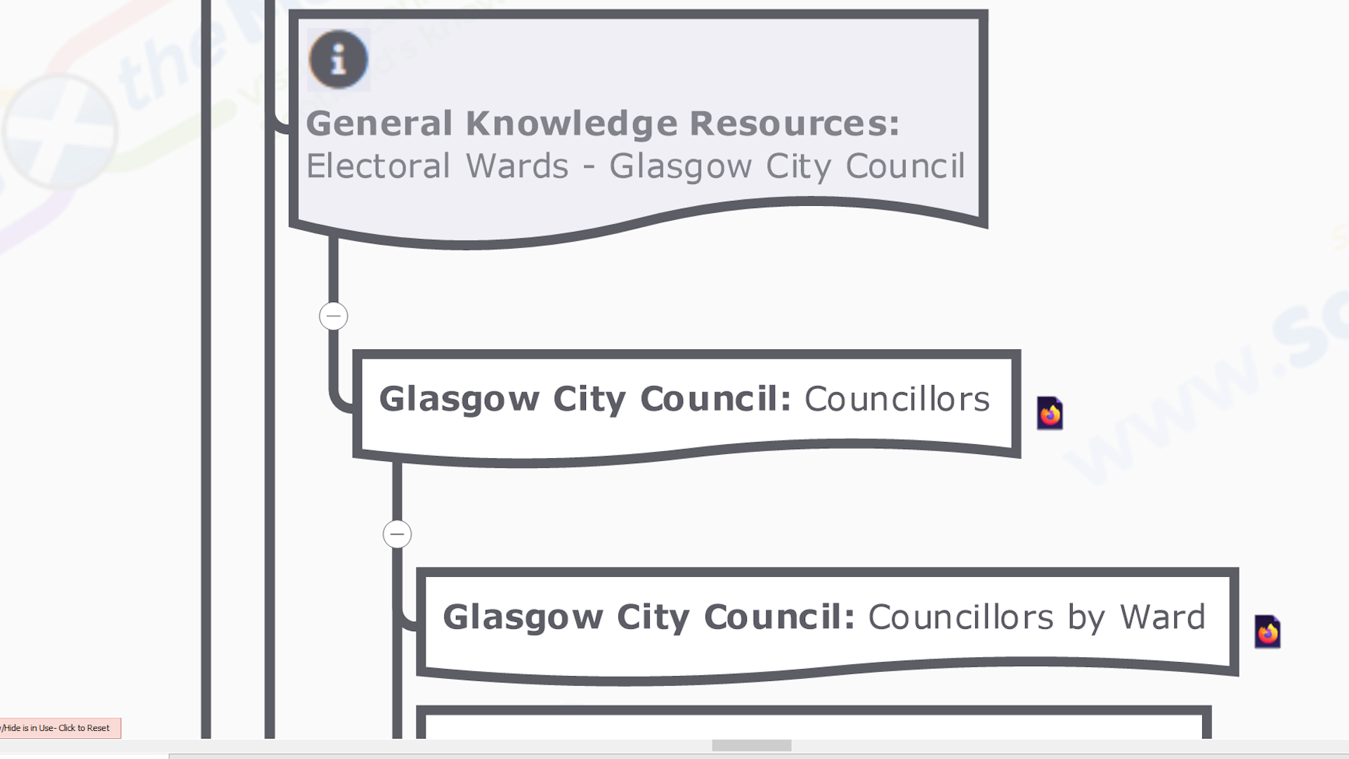
Scottish Local Council Electoral Wards
This collection contains links to official / definitive / ‘plain old useful’ general knolwedge resources about the Scottish Local Council. It is an ideal starting point for those who want to find out more about about it, be it for casual browsing or more focused desktop research for a specific purpose…
Note(s)
i) It is usually the case that the only council resource listed will be the council’s web page on which councillors are listed by ward, though some do produce geo-statistical profiles of their individual wards.
ii) There will always be a link to the Council Area Electoral Ward section on the geostatistical atlas section of the statistics.gov.scot online data portal, where a range of ‘official’ data about the ward can be explored.
The following knowledge resource links form this collection…
![]() Council Website: ‘Councillors by Ward’ page – This may be a separate page for each ward, or the subsection of a single page, or just the general ‘Councillors’ page if there’s no listing by ward.
Council Website: ‘Councillors by Ward’ page – This may be a separate page for each ward, or the subsection of a single page, or just the general ‘Councillors’ page if there’s no listing by ward.
![]() Council Website: Ward Profile – Very occasionally councils produce their own ward profiles, combining information from different official statistical sources and their own comment to provide a deeper understanding.
Council Website: Ward Profile – Very occasionally councils produce their own ward profiles, combining information from different official statistical sources and their own comment to provide a deeper understanding.
![]() Scottish Government Statistics Portal: Individual electoral ward profile – This is the Ward section on the geostatistical atlas section of the statistics.gov.scot website. As well as key facts, the data about the individual Ward is grouped as…
Scottish Government Statistics Portal: Individual electoral ward profile – This is the Ward section on the geostatistical atlas section of the statistics.gov.scot website. As well as key facts, the data about the individual Ward is grouped as…
- Population
- Children
- Education
- Training
- Housing
- Health
- Community
- Crime
- Justice
Geographic Knowledge Resource Links Collection

Scottish Local Council Electoral Wards
This collection contains links to official / definitive / ‘plain old useful’ geographic knolwedge resources about the the Scottish Local Council. It is a mixture of…
- Static Map Libraries – Collections of human created cartographic image files that can be downloaded and viewed offline.
- Online Mapping Services – Automatically generate maps, often with different ‘layers’ of related geographic features that can be turned on or off and additional useful geographic tools (eg. route finder). These can usually only be accessed via a live internet connection.
- Spatial Data Repositiories – Containing data files of computer-readable geographic information for use by anybody with the right specialised (‘GIS’) software. As well as being downloadable files, they may also be available as a feature service that is streamed directly to your application using an API.
Note(s)
i) It is sometimes the case that the only resource listed will be the relevant Local Government Boundary Commission for Scotland’s Electoral Review static (i.e. a PDF) ward boundary map (as noted elsewhere this is not always from the most recent (i.e. Fifth) Review).
ii) Councils sometimes (but mostly don’t) provide a static overview map of wards. They may have an interactive online mapping system on which all ward boundaries (and sometimes councillor details) can be displayed. However such is the technical setup of these systems that it is not possible to externally link to views of specific objects with a single ‘layer’ (eg. individual wards) in the map, only the map page as a whole, and so users have to go to the effort of turning on the layers they require and ‘zooming in’ to the feature they’re looking for each time they open they open it.
iii) It is surprisingly common for there to be poor / no linking to the geographic resources from the ‘councillor by ward page’ so users would have to hunt for them (if they even knew they existed) in the absence of our handy map 🙂
The following knowledge resource links form this collection…
![]() Council Website: Map page(s) (if present) – The variety and quality of map resources published by Scottish Local Councils in regard to their Electoral Wards is very varied….
Council Website: Map page(s) (if present) – The variety and quality of map resources published by Scottish Local Councils in regard to their Electoral Wards is very varied….
- Downloadable ‘static’ PDF files showing the ward boiundary.
- Online digital mapping system, where boundaries can be viewed along with other ‘layers’ of map data about the Council Area (though unfortunately such is the technical setup of these that links to views of specific things are not provided and cannot be created without a considerable amount of effort).
- No extra resources but links to the Local Government Boundary Commission Ward Maps on their website.
- No geographic info at all :-(.
![]() Local Government Boundary Commission for Scotland Latest Electoral Review of the Council Ward Boundaries & the Number of Councillors – The Local Government Boundary Commission for Scotland (LGBCS) is the body officially tasked with defining electoral ward boundaries and the number councillors to be elected to them, and continuing to review these arrangements on a regular basis…
Local Government Boundary Commission for Scotland Latest Electoral Review of the Council Ward Boundaries & the Number of Councillors – The Local Government Boundary Commission for Scotland (LGBCS) is the body officially tasked with defining electoral ward boundaries and the number councillors to be elected to them, and continuing to review these arrangements on a regular basis…
Note(s)
i) Most Council Area wards conform to the 5th Electoral Review carried out by the LGBCS, whose final recommendations for the number of councillors and the electoral ward boundaries in each of Scotland’s 32 local authorities was submitted to Scottish Ministers on 26 May 2016 and came into effect for elections held on or after 4th May 2017.
ii) For those Council Areas where the recommendations for the 5th Review were rejected by ministers, the number of councillors and the electoral ward boundaries of the 4th Review remain in place. For reference these are…
- Argyll and Bute Council
- Comhairle nan Eilean Siar [Council of the Western Isles]
- Dundee City Council
- Scottish Borders Council
- Shetland Islands Council
![]() Local Government Boundary Commission for Scotland: Council Area Overview Map 2017 [PDF] – The Local Government Boundary Commission for Scotland (LGBCS) helpfully publish GIS produced, ward boundary maps in PDF (i.e. static) format as part of their periodic review process. The maps show the boundaries against an Ordnance Survey basemap, and can be easily printed if required.
Local Government Boundary Commission for Scotland: Council Area Overview Map 2017 [PDF] – The Local Government Boundary Commission for Scotland (LGBCS) helpfully publish GIS produced, ward boundary maps in PDF (i.e. static) format as part of their periodic review process. The maps show the boundaries against an Ordnance Survey basemap, and can be easily printed if required.
There will be…
- an overview map of the whole Council Area showing where all the wards are relative to each other,
- Individual ward maps
Note(s)
i) The 4th and 5th electoral Review maps have different styles so it is easy to see to tell which boundaries apply at a glance.
Electoral Knowledge Resource Links Collection

Scottish Local Council Electoral Wards
This collection contains links to official / definitive / ‘plain old useful’ knolwedge resources about elections in the Scottish Local Council Ward, both the nationally held elections that take place every 5 years (last one in May 2017), and subsequent by elections initiated by the resignation or death of a sitting counsellor. It is an ideal starting point for those who want to find out more about about them, be it for casual browsing or more focused desktop research for a specific purpose…
Note(s)
i) Councils vary a lot on how they present this knowledge on their own websites, and often it is surprisingly difficult to find given that that the election of councillors is the primary process of local democracy. For example…
- no election results to be obviously found (though they may be buried in there somewhere).
- election results only of individual wards, not of the council as a whole.
- results only in static reports that need to be downloaded (especially if combined wth the previous point of a separate document for each ward).
- ‘headline’ results only, missing the detail of the mult-stage counts of the proportional representation electoral system used.
ii) Fortunately there are enough ‘political anoraks’ out there that Wikipedia has all the knowledge you could need about the most recent, and all previous, elections to the Local Council, including by-elections, down to individual ward level. There is also plenty of additional contextual knolwedge.
iii) The Edinburgh based academic Prof Denis Mollison has taken it upon himself to comprehensively document the results of the last two (2017 & 2012) Local Council elections on his own website. This includes the details of all the mult-stage counts of the proportional representation electoral system down to individual ward level, although there is no additional contextual knowledge though.
The following knowledge resource links form this collection…
![]() Council Website: ‘Election’ pages – Local Councils are responsible for facilitating voting in ALL elections and referendums, local or national, so all council websites have a section on ‘Elections’…
Council Website: ‘Election’ pages – Local Councils are responsible for facilitating voting in ALL elections and referendums, local or national, so all council websites have a section on ‘Elections’…
- These cover all the elections the council organises. We have only included the pages relevant to the local council ones.
- These may or may not include the actual results of the election.
- Where results are covered, they may not include the full results at ward level of all stages of the single transferable vote counting i.e. you can’t actually rely on the level of detail found in the other sources of local council election results to be present on the actual council website!
![]() Denis Mollison Scottish Council Election May 2017: Summary of Election Results for Individual Electoral Ward – Denis is Professor of Applied Probability (Emeritus) at Heriot-Watt University in Edinburgh. Through his own website he has published the full results of the 2017 and 2012 Scottish Local Council elections at council and ward level (including all the counting stages of the Single Transferable Vote proportional representation system used).
Denis Mollison Scottish Council Election May 2017: Summary of Election Results for Individual Electoral Ward – Denis is Professor of Applied Probability (Emeritus) at Heriot-Watt University in Edinburgh. Through his own website he has published the full results of the 2017 and 2012 Scottish Local Council elections at council and ward level (including all the counting stages of the Single Transferable Vote proportional representation system used).
![]() [*NEW*] Who Can I Vote For? by Democracy Club – This is a ‘newly discovered by us’ website (discovered in the course of mapping the UK Parliament for the impending 2019 General Election) that not only lists all UK local and national elections and by-elections since 2016 (s well as the 2015 & 2010 UK General Elections), but also has crowd-sourced details about all the candidates standing in each and every constituency or ward (eg. links to their official websites and social media as well as previous elections they may have stood in that they have details of). This particular link is to a page for the last (2017) Local Council election in the individual ward (there will be other links for any by-elections that have happened since).
[*NEW*] Who Can I Vote For? by Democracy Club – This is a ‘newly discovered by us’ website (discovered in the course of mapping the UK Parliament for the impending 2019 General Election) that not only lists all UK local and national elections and by-elections since 2016 (s well as the 2015 & 2010 UK General Elections), but also has crowd-sourced details about all the candidates standing in each and every constituency or ward (eg. links to their official websites and social media as well as previous elections they may have stood in that they have details of). This particular link is to a page for the last (2017) Local Council election in the individual ward (there will be other links for any by-elections that have happened since).
Note(s)
i) The Democracy Club community interest company and associated volunteers are to be congratulated for the ‘Herculean’ efforts in creating this comprehensive, publicly accessible and free to use knowledge resource about all elections in the UK, and we do not envy them their task! The Who Can I Vote For? website is a constant work in progress so we’re sure it will change in the future, but as it stands right now, from our ‘knowledge mapping of links’ point of view, we have a few observations…
Elections
- There is one ‘All Elections’ page that, as the title suggests, lists all the UK elections covered by the site…
- European Parliament
- London Assembly
- Local Council
- Mayoral
- Police and Crime Commissioner
- Northern Ireland Assembly
- Referendum
- Scottish Parliament
- Senedd Cymru
- UK Parliament
- These are listed first by calendar date of occurence (in reverse order), and then alphabetically within that date group. So there is not a single page for a particular Local Council (or any other electoral area covered) that lists the links to all the elections that have happened there, including subsequent by-elections 🙁 .
- As can be imagined from the list of type of elections covered above, there is a lot to scroll through to find what you want (there is no search or filtering feature). So you really have to know the date when the election you are interested in happened in order to find it on the page before you can start drilling down. That said all the Scottish Local Council general elections take place on the same day (the first thursday in May), which helps (the same is not true for by-elections obviously).
- Elections in individual wards are not listed on this page, instead it will say ‘Such and such Council local election or by-election’. Clicking on that link will take you to the Local Council ‘front page’ where the wards are listed, and you then click on that link to get to the actual election page where the candidate listing is.
- After the election, the ward page of all the candidates is updated to indicate which one was successfully elected, but it does not list the votes for each candidate. This is actually very understandable given the proportional representation system used in Scottish Local Elections in which the votes cast at the first count get redistributed as candidates get eliminated at each stage until the pre-determined quota is reached. However it does mean that this is not an ‘everything you want to know about the election in the ward all conveniently gathered into the one place’ knowledge resource (in the same way the election listing on Wikipedia only shows the results with no information about the candidates other than their party as the vast majority of them will not have a Wikpedia page that can be linked to).
- No unique identifying codes are used for the electoral units anywhere on the site and so units they are only identified by name.
Candidates
- The contents of an individual candidate’s page is entirely dependent on what’s been added by local volunteers and so it varies a lot – from “no further information on this candidate” to all their social media accounts.
- It also relates to the last election they stood in, which could be in a different political ‘arena’. For example it is not uncommon for local councillors to stand for election as a member of the UK or Scottish Parliaments.
- A far as an individual’s election history section goes this is entirely dependent on what’s in the database. Thus if they stood for election before 2016, unless it was at the 2010 or 2015 UK General Elections, this section will be blank.
![]() Wikipedia: Summary article of 2017 Scottish Council Election Results for Council Area #Individual Ward – Wikipedia has the results of all local council elections down to ward level going back a considerable period of time and is the best single place to get an overview of the changes in political composition of local councils over time. The results for each ward are usually a sub-section within the page.
Wikipedia: Summary article of 2017 Scottish Council Election Results for Council Area #Individual Ward – Wikipedia has the results of all local council elections down to ward level going back a considerable period of time and is the best single place to get an overview of the changes in political composition of local councils over time. The results for each ward are usually a sub-section within the page.
We are continually striving to…
- find further, freely accessible in the public domain, definitive / official / plain old useful 🙂 knowledge resources about the ‘national local’ building blocks of Scotland to link to.
- incorporate more contextual knowledge where possible.
- and just generally push knowledge mapping to the limits :-).
All whilst keeping the existing map content up to date and not visually overwhelming the end users 🙂
The changelog(s) below summarise the actions undertaken to initially create – and subsequently update & improve – this knowledge map…
Note(s)
i) Version numbering – Our maps are principally referenced by their date of publication, however we also assign them a version number so we can internally keep track of them through the development process as publication dates are only decided during the final stages of the map creation / update process. Version 1.0 is obviously the first – and indeed may be the only – version of that map we have ever published. What version number comes next will depend on the subject matter….
- Maps involving electoral and political processes – Version numbers will be tied to the real world electoral cycle of the institution, which is usually regular, or at least has a maximum duration (eg. general elections to the Scottish Parliament or Scottish Local Councils are every 5 years, whilst to the UK Parliament it is every 5 years at most). By-elections – caused by the resignation / death of an elected member – are unpredicatable by their very nature. Thus the version number will be increased by 1 for the map published after general elections (eg. from 1.0 to 2.0), whilst updates due to by-elections by a decimal increment (eg. from 1.0 to 1.1). In either case the new version may also include other changes to the content, such as the incorporation of links to more knowledge resources and/or embedded/attached contextual knowledge elements.
ii) Update frequency – Maps by their very nature – a visually structured knowledge record of the ‘real world’ created through ‘field’ survey and data collection – are tied to a publication date, which users need to take cognisance of as the real world inevitably changes over time. How often we update and re-publish a map will depend on the frequency of those real world changes, and our own resources (with the best will in the world we will always be playing catch-up)…
- Maps involving electoral and political processes – As already mentioned the frequency of General Elections are mostly preset, and so we will endeavour to update a map as soon as practicable after them (though it may take a while for the knowledge resources to catch up with events, especially for newly elected members). The frequency of by-elections however varies greatly, there is a lot more ‘natural churn’ of the 1,127 Scottish Local Councillors compared to just 59 UK Parliament Scottish MPs (the last UK by-election in Scotland was Inverclyde in 2011). Thus electoral maps involving Local Councillors will be need to be updated and re-published more frequently.
Scottish Local Council Electoral Wards General & Geographic Knowledge Atlas (16 May 2020)
![]() Version – 1.2
Version – 1.2
.
![]() Map Branches – 4,968
Map Branches – 4,968
.
![]() Links to knowledge resources – 6,514
Links to knowledge resources – 6,514
.
![]() File Sizes – HTML5 (.html): 23.6 MB; MindManager (.mmap): 16.2 MB
File Sizes – HTML5 (.html): 23.6 MB; MindManager (.mmap): 16.2 MB
.
![]() Basemap(s) Framework – The following existing knowledge map(s) was(were) the starting point for the creation of this map (note these in turn may be based on other existing maps, check the changelogs in their listing for more information)….
Basemap(s) Framework – The following existing knowledge map(s) was(were) the starting point for the creation of this map (note these in turn may be based on other existing maps, check the changelogs in their listing for more information)….
![]() Scottish Local Councils General & Geographic Knowledge .Atlas (25 Jan 2020) (v1.1)
Scottish Local Councils General & Geographic Knowledge .Atlas (25 Jan 2020) (v1.1)
.
![]() Actions – The main work done in making this version of the map was…
Actions – The main work done in making this version of the map was…
![]() Prepare basemap
Prepare basemap
This is an update to the Scottish Local Councils General & Geographic Knowledge .Atlas (25 Jan 2020) (v1.1) basemap rather than a re-purposing to create another, so no particular preparation is required.
![]() Update with links to knowledge resources for recent by-elections
Update with links to knowledge resources for recent by-elections
Add links to the appropriate seed branches and knowledge link sub-branch collections for knowledge resources about the 1 local by-election (see notes below) that have taken place since the last version of this map was published on 25 Jan 2020…
- 12/03/2020 Eilean a’ Chèo [Highland Council]
.
Note(s)
i) Effects of the Covid Pandemic – There was a slew of elections planned from March to 14th May, however it transpires that only the earliest one took place as planned, whilst the rest have been postponed due to the Coronoavirus Crisis. The UK Government has posponed all local elections in England & Wales until the 6th of May 2021 (when the next Local Council elections are scheduled) at least. However though the scheduled elections in Scotland have been postponed for now, the re-scheduled dates where set are in October & November. Presumably it will depend on the public health guidance issued by the Scottish Government closer to the time as to whether they will go ahead as planned.
ii) To publish or not? – As there is only one declared result since this map was last published, we did contemplate just amending that last map with that one election and re-publishing it. In the end though we thought that the momentous events & consequences of the Covid Pandemic were best acknowledged in a separate map, and we anticipate that it will be a wee while before we publish another update of it.
iii) Updates due to changes in Electoral knowledge resource content – There is a reasonably constant ‘churn’ of elected Local Councillors due to illness, death and party shenanigans, which gives rise to ‘a dozen or so’ local by-elections each year. Whilst this is a map about Electoral Wards rather than elected Local Councillors, the only reason the former exist is for the election of the latter so when there are elections, there are new links to electoral knowledge resources that need to be incorporated. This means we will probably need to update and re-publish this map every 3 to 4 months or so (whilst the results themselves will be incorporated into the Political Knowledge Atlas, triggering that to be updated and re-issued in turn). However the precise timing will be dependant on the actual dates of the local by-elections, which tend to come in ‘clumps’ rather than being evenly distributed throughout the year (eg. there is a tendency to avoid holding them in winter months if possible).
iv) Updates due to changes in General knowledge resource content – Geo-statistics such as ‘Population Estimates’ are published annually for many official statistical areas, including Local Council areas (usually around June ie. the middle of the year). Not only is this data embedded within knowledge seed branches, it feeds into calculated data fields eg. ‘Population Density’ is the Population figure divided by the Geographic Area figure. Thus one of the map updates inititiated by by-elections will include updated geostats embedded in the seed branches (and should there be no by-elections over a prolonged period for some strange reason, this will be reason enough to republish this map at least annually but surely that wouldn’t happen… would it?).
v) Updates due to changes in Geographic knowledge resource content – The geographic apect of Electoral Wards – basically their boundaries with neighbouring wards – is the most stable, at least compared to an annual update cycle. However they are not static in perpetuity….
- Scheduled boundary reviews – There are ‘standing orders’ to review the boundaries of all electoral areas every 10-12 years or so, so that the ‘electorate to elected member ratio’ is the same, or at least within defined ‘quota’ limits (so that each vote ‘counts the same’ in an election no matter where the voter lives). With general electoral cycles of 5 years, this means that boundaries are fixed for at least 2 general elections. And it is usually the case that not all boundaries are changed at a regular review as some areas will still be deemed to be within ‘quota’ limits, so those boundaries may persist unaltered for 20 years or so.
- Interim reviews – these may happen at the local level (ie. only affecting 2 or 3 areas with mutual borders) due to some change in local circumstances. They happen very infrequently, and not without an extensive prior consultation process (ie. they don’t just suddenly happen), so any that do occur will be picked up in the at least annual reviews of the map.
vi) General map evolution – As mentioned already we are continually striving to improve our map making processes. This impacts content in 2 ways….
- Improving the way we present content – as well as us just getting better at this whole information cartography malarky (especially when it comes to mapping electoral knowledge), MindManager software is continually being developed and we will take advantage of new or improved features where possible (for example the ability to change the thickness of the lines for map branches was a ‘cartographic game changer’ as far as we were concerned when it was introduced a couple of years ago) .
- Extending the content – this can be extending the range of the existing content (eg. including electoral results from a more extended period), as well as including newly discovered resources.
Whichever, if these developments are advancd enough they will merit revision and re-puplishing of the map. (The Local Council Elections in 2022 will probably see a major revision, but a lot of development water will have passed under the bridge before then 🙂 ).
Scottish Local Council Electoral Wards General & Geographic Knowledge Atlas (25 Jan 2020)
![]() Version – 1.1
Version – 1.1
.
![]() Map Branches – 4,951
Map Branches – 4,951
.
![]() Links to knowledge resources – 6,479
Links to knowledge resources – 6,479
.
![]() File Sizes – HTML5 (.html): 23.6 MB; MindManager (.mmap): 16.2 MB
File Sizes – HTML5 (.html): 23.6 MB; MindManager (.mmap): 16.2 MB
.
![]() Basemap(s) Framework – The following existing knowledge map(s) was(were) the starting point for the creation of this map (note these in turn may be based on other existing maps, check the changelogs in their listing for more information)….
Basemap(s) Framework – The following existing knowledge map(s) was(were) the starting point for the creation of this map (note these in turn may be based on other existing maps, check the changelogs in their listing for more information)….
![]() Scottish Local Council Electoral Wards General & Geographic Knowledge Atlas (30 Sep 2019) (v1.0)
Scottish Local Council Electoral Wards General & Geographic Knowledge Atlas (30 Sep 2019) (v1.0)
.
![]() Actions – The main work done in making this version of the map was…
Actions – The main work done in making this version of the map was…
![]() Prepare basemap
Prepare basemap
This is an update to the Scottish Local Councils General & Geographic Knowledge Atlas (19 Sep 2019) (v1.0) basemap rather than a re-purposing to create another, so no particular preparation is required.
![]() Add new Electoral Knowledge resource links to seed branches
Add new Electoral Knowledge resource links to seed branches
In the process of creating our UK Parliament 2019 General Election knowledge maps we discovered the Who Can I Vote For? by Democracy Club website, which contains crowd-sourced details of all the candidates standing in each ward or constituency at every UK local & parliamentary election / by-election since 2016. There is a dedicated (and linkable 🙂 page to the 2017 Local Council election (and every subsequent local by-election) for every Local Council and their Electoral Wards. So we’ve added links to them as Electoral knowledge link collection sub-branches and links attached to all the existing seed branches at both individual ward and ‘Whole Council’ level. Going forward links to the Who Can I Vote For? website will be included as standard on all our knowledge maps involving eletoral areas and elected members.
![]() Update with links to knowledge resources for recent by-elections
Update with links to knowledge resources for recent by-elections
Add links to the appropriate seed branches and knowledge link sub-branch collections for knowledge resources about the 9 local by-elections that have taken place since the 1st version of this map was published on 30 Sep 2019…
- 03/10/2019 Bridge of Don Ward [Aberdeen City Council]
- 07/11/2019 Lerwick South Ward [Shetland Islands Council]
- 07/11/2019 Shetland Central Ward [Shetland Islands Council]
- 14/11/2019 Inverness Central Ward [Highland Council]
- 14/11/2019 Dunfermline Central Ward [Fife Council]
- 14/11/2019 Rosyth Ward [Fife Council]
- 21/11/2019 Keith and Cullen Ward [Moray Council]
- 21/11/2019 Torry/Ferryhill Ward [Aberdeen City Council]
- 23/01/2020 Mid Galloway and Wigtown West Ward [Dumfries and Galloway Council]
![]() Update ‘Map Legend’ & ‘Contributing Online Knowledge-bases’ metabranches
Update ‘Map Legend’ & ‘Contributing Online Knowledge-bases’ metabranches
Add any new resources and descriptions of new links to the meta branches.
.
Note(s)
i) Updates due to changes in Electoral knowledge resource content – There is a reasonably constant ‘churn’ of elected Local Councillors due to illness, death and party shenanigans, which gives rise to ‘a dozen or so’ local by-elections each year. Whilst this is a map about Electoral Wards rather than elected Local Councillors, the only reason the former exist is for the election of the latter so when there are elections, there are new links to electoral knowledge resources that need to be incorporated. This means we will probably need to update and re-publish this map every 3 to 4 months or so (whilst the results themselves will be incorporated into the Political Knowledge Atlas, triggering that to be updated and re-issued in turn). However the precise timing will be dependant on the actual dates of the local by-elections, which tend to come in ‘clumps’ rather than being evenly distributed throughout the year (eg. there is a tendency to avoid holding them in winter months if possible).
ii) Updates due to changes in General knowledge resource content – Geo-statistics such as ‘Population Estimates’ are published annually for many official statistical areas, including Local Council areas (usually around June ie. the middle of the year). Not only is this data embedded within knowledge seed branches, it feeds into calculated data fields eg. ‘Population Density’ is the Population figure divided by the Geographic Area figure. Thus one of the map updates inititiated by by-elections will include updated geostats embedded in the seed branches (and should there be no by-elections over a prolonged period for some strange reason, this will be reason enough to republish this map at least annually).
iii) Updates due to changes in Geographic knowledge resource content – The geographic apect of Electoral Wards – basically their boundaries with neighbouring wards – is the most stable, at least compared to an annual update cycle. However they are not static in perpetuity….
- Scheduled boundary reviews – There are ‘standing orders’ to review the boundaries of all electoral areas every 10-12 years or so, so that the ‘electorate to elected member ratio’ is the same, or at least within defined ‘quota’ limits (so that each vote ‘counts the same’ in an election no matter where the voter lives). With general electoral cycles of 5 years, this means that boundaries are fixed for at least 2 general elections. And it is usually the case that not all boundaries are changed at a regular review as some areas will still be deemed to be within ‘quota’ limits, so those boundaries may persist unaltered for 20 years or so.
- Interim reviews – these may happen at the local level (ie. only affecting 2 or 3 areas with mutual borders) due to some change in local circumstances. They happen very infrequently, and not without an extensive prior consultation process (ie. they don’t just suddenly happen), so any that do occur will be picked up in the at least annual reviews of the map.
iv) General map evolution – As mentioned already we are continually striving to improve our map making processes. This impacts content in 2 ways….
- Improving the way we present content – as well as us just getting better at this whole information cartography malarky (especially when it comes to mapping electoral knowledge), MindManager software is continually being developed and we will take advantage of new or improved features where possible (for example the ability to change the thickness of the lines for map branches was a ‘cartographic game changer’ as far as we were concerned when it was introduced a couple of years ago) .
- Extending the content – this can be extending the range of the existing content (eg. including electoral results from a more extended period), as well as including newly discovered resources.
Whichever, if these developments are advancd enough they will merit revision and re-puplishing of the map. (The Local Council Elections in 2022 will probably see a major revision, but a lot of development water will have passed under the bridge before then 🙂 ).
Scottish Local Council Electoral Wards General & Geographic Knowledge Atlas (30 Sep 2019)
![]() Version – 1.0
Version – 1.0
.
![]() Map Branches – 4,461
Map Branches – 4,461
.
![]() Links to knowledge resources – 5.511
Links to knowledge resources – 5.511
.
![]() File Sizes – HTML5 (.html): 23.5 MB; MindManager (.mmap): 16.1 MB
File Sizes – HTML5 (.html): 23.5 MB; MindManager (.mmap): 16.1 MB
.
![]() Basemap(s) Framework – The following existing knowledge map(s) was(were) the starting point for the creation of this map (note these in turn may be based on other existing maps, check the changelogs in their listing for more information)….
Basemap(s) Framework – The following existing knowledge map(s) was(were) the starting point for the creation of this map (note these in turn may be based on other existing maps, check the changelogs in their listing for more information)….
![]() Scottish Local Councils General & Geographic Knowledge Atlas (19 Sep 2019) (v1.0)
Scottish Local Councils General & Geographic Knowledge Atlas (19 Sep 2019) (v1.0)
.
![]() Actions – The main work done in making this version of the map was…
Actions – The main work done in making this version of the map was…
![]() Prepare basemap
Prepare basemap
Starting with the Scottish Local Councils General & Geographic Knowledge Atlas (19 Sep 2019) (v1.0) basemap, remove all the ‘knowledge link collection sub-branches’ for each Local Council and replace with 2 ‘collection type’ sub-branches – one for ‘Individual Wards’ (for the ward seed branches), and one for ‘Whole Council’ (for resources about all the Council’s Electoral Wards as a whole).
![]() Create Electoral Ward proto seed branches
Create Electoral Ward proto seed branches
Create proto seed branches for individual Electoral Wards by importing the ‘live’ (as opposed to ‘archived’) entries from the ‘S13 Electoral Wards’ workbook in the Scottish Government’s Standard Geographic Codes Register – Scotland Excel spreadsheet, part of the Small Area Statistics Reference Documents. Add them as sub-branches to the ‘Individual Wards’ collection branch for each Local Council. Again we have gone with a straightforward alphabetic A-Z layout.
![]() Create Electoral Ward knowledge seed branches
Create Electoral Ward knowledge seed branches
Do everything required to turn those bare proto branches into full blown knowledge seed branches about Local Council Electoral Wards. So…. starting with the multiple links attached to the Local Council seed branches in the basemap (see what we did there ;-), tracking down official / defnitive / plain old useful general, geographic & electoral knowledge resources about Electoral Wards, and using the knowledge contained therein to embed and attach contextual knowledge elements to build up the knowledge seed branches in the usual organic, iterative process. Note the ‘Contributing Online Knowledge-bases’ meta branch is created during this process as a working area to collect, triage and manage links to discovered knowledge resources before adding to the seed branches.
![]() Create Electoral Ward knowledge link collection sub-branches
Create Electoral Ward knowledge link collection sub-branches
Addition of links to said knowledge resources about individual Electoral Wards as stylised individual sub-branches arranged in general, geographic and electoral knowledge resources collections attached to each individual Electoral Ward seed branch. Repeat for ‘Council as a Whole’ resources about Electoral Wards. Note the titles of all links have to be manually changed from that supplied automatically by the resource website to our standard nomenclature of ‘Source – Title’ eg. ‘Wikipedia – Wards of Glasgow‘ (as opposed to ‘Wards of Glasgow – Wikipedia’).
![]() Attached multiple links to seed branches
Attached multiple links to seed branches
Add the links to the core resources from the collections as multiple links on the Electoral Ward seed branch so that they remain part of the branch, even if it is re-purposed or re-used in other maps. Repeat for ‘Council as a whole’ resource links by adding them to the ‘Whole Council’ collection branch.
![]() Create ‘Map Legend’ meta branch
Create ‘Map Legend’ meta branch
With the seed branch content finalised, create the Map Legend meta branch to fully describe all the branches and the knowledge elements attached to / embedded within them. Note all the content of the ‘Seed Branches’ and ‘Link Collections’ tabs on this page are also included in the ‘Map Legend’ meta branch.
![]() Finalise ‘Contributing Online Knowlege-bases’ meta branch
Finalise ‘Contributing Online Knowlege-bases’ meta branch
As the main ‘working area’ of the map during development, the final content needs to be decided, redundant content removed, and what’s left tidied up and given the old ‘informati0n cartography’ magic. Note not all the resources we discover are ‘linkable to’ from the perspective of individual knowledge seed branches, but if we deem them useful they can at least still be included in the map here. Also only the resource content that is relevant to the map is documented here, though each level of the navigation pathway to that content is included as hierarchical sub-branches so that it is discoverable within a bigger picture context.
.
Note(s)
i) Updates due to changes in Electoral knowledge resource content – There is a reasonably constant ‘churn’ of elected Local Councillors due to illness, death and party shenanigans, which gives rise to ‘a dozen or so’ local by-elections each year. Whilst this is a map about Electoral Wards rather than elected Local Councillors, the only reason the former exist is for the election of the latter so when there are elections, there are new links to electoral knowledge resources that need to be incorporated. This means we will probably need to update and re-publish this map every 3 to 4 months or so (whilst the results themselves will be incorporated into the Political Knowledge Atlas, triggering that to be updated and re-issued in turn). However the precise timing will be dependant on the actual dates of the local by-elections, which tend to come in ‘clumps’ rather than being evenly distributed throughout the year (eg. there is a tendency to avoid holding them in winter months if possible). Here’s a list of the 23 that have taken place since the last Scottish Council Election on 4 May 2017 (the knowledge resources about which have been included in this map)…
- 13/07/2017 Elgin City North Ward [Moray Council]
- 07/09/2017 Cardonald Ward [Glasgow City Council]
- 07/09/2017 Fortissat Ward [North Lanarkshire Council]
- 28/09/2017 Tain and Easter Ross Ward [Highland Council]
- 12/10/2017 Inverurie and District Ward [Aberdeenshire Council]
- 23/11/2017 Perth City South Ward [Perth and Kinross Council]
- 23/11/2017 Rutherglen Central and North Ward [South Lanarkshire Council]
- 15/02/2018 Bonnybridge and Larbert Ward [Falkirk Council]
- 22/02/2018 Selkirkshire Ward [Scottish Borders Council]
- 01/03/2018 Clackmannanshire North Ward [Clackmannanshire Council]
- 22/03/2018 Penicuik Ward [Midlothian Council]
- 05/04/2018 Caol and Mallaig Ward [Highland Council]
- 19/04/2018 Highland Ward [Perth and Kinross Council]
- 06/09/2018 Inverkeithing and Dalgety Bay Ward [Fife Council]
- 25/10/2018 Coatbridge South Ward [North Lanarkshire Council]
- 06/12/2018 Wester Ross, Strathpeffer and Lochalsh Ward [Highland Council]
- 13/12/2018 Dee and Glenkens Ward [Dumfries and Galloway Council]
- 28/03/2019 Clackmannanshire Central Ward [Clackmannanshire Council]
- 11/04/2019 Leith Walk Ward [City of Edinburgh Council]
- 02/05/2019 North East Ward [Dundee City Council]
- 09/05/2019 Haddington and Lammermuir Ward [East Lothian Council]
- 29/08/2019 East Kilbride Central North Ward [South Lanarkshire Council]
- 19/09/2019 Thorniewood Ward [North Lanarkshire Council]
ii) Updates due to changes in General knowledge resource content – Geo-statistics such as ‘Population Estimates’ are published annually for many official statistical areas, including Local Council areas (usually around June ie. the middle of the year). Not only is this data embedded within knowledge seed branches, it feeds into calculated data fields eg. ‘Population Density’ is the Population figure divided by the Geographic Area figure. Thus one of the map updates inititiated by by-elections will include updated geostats embedded in the seed branches (and should there be no by-elections over a prolonged period for some strange reason, this will be reason enough to republish this map at least annually).
iii) Updates due to changes in Geographic knowledge resource content – The geographic apect of Electoral Wards – basically their boundaries with neighbouring wards – is the most stable, at least compared to an annual update cycle. However they are not static in perpetuity….
- Scheduled boundary reviews – There are ‘standing orders’ to review the boundaries of all electoral areas every 10-12 years or so, so that the ‘electorate to elected member ratio’ is the same, or at least within defined ‘quota’ limits (so that each vote ‘counts the same’ in an election no matter where the voter lives). With general electoral cycles of 5 years, this means that boundaries are fixed for at least 2 general elections. And it is usually the case that not all boundaries are changed at a regular review as some areas will still be deemed to be within ‘quota’ limits, so those boundaries may persist unaltered for 20 years or so.
- Interim reviews – these may happen at the local level (ie. only affecting 2 or 3 areas with mutual borders) due to some change in local circumstances. They happen very infrequently, and not without an extensive prior consultation process (ie. they don’t just suddenly happen), so any that do occur will be picked up in the at least annual reviews of the map.
iv) General map evolution – As mentioned already we are continually striving to improve our map making processes. This impacts content in 2 ways….
- Improving the way we present content – as well as us just getting better at this whole information cartography malarky (especially when it comes to mapping electoral knowledge), MindManager software is continually being developed and we will take advantage of new or improved features where possible (for example the ability to change the thickness of the lines for map branches was a ‘cartographic game changer’ as far as we were concerned when it was introduced a couple of years ago) .
- Extending the content – this can be extending the range of the existing content (eg. including electoral results from a more extended period), as well as including newly discovered resources.
Whichever, if these developments are advancd enough they will merit revision and re-puplishing of the map. (The Local Council Elections in 2022 will probably see a major revision, but a lot of development water will have passed under the bridge before then 🙂 ).
Created using our unique mix of professional information hunting & cartography skills and MindManager, the world leading information mapping software, our ground-breaking knowledge maps are an interactive, visualy structured, ‘discover within the bigger picture context’ index of…
- what ‘building blocks’ make up a given ‘knowledge space’.
- what knowledge resources about them exist in the public domain.
- the links to where those resources are online (ie. their URL), so map users can access them ‘there and then’ with a click of their mouse.
Anatomy of a knowledge map
Our knowledge maps are built from 2 different sorts of components that together, we hope you agree, make something that is much greater than the sum of it’s individual parts…

Hierarchical framework of interconnected branches
The framework of the knowledge map is made up of interconnected branches – of varying colours, shapes, and sizes, which are arranged in a visually connected hierarchy around a central topic. There are different ‘types’ of branches within our knowledge maps (though the types are not all mutually exclusive).

Embedded / attached knowledge elements
Each branch in the map has a mix of elements – often unque to MindManger – embedded within, or attached to, it and/or has some other physical attribute, that conveys core knowledge, or link to primary knowledge resources, about the ‘real world building block’ the branch represents.
Find out more below…
The framework of the knowledge map is made up of interconnected branches (of varying colours, shapes and sizes), which are arranged in a visually connected hierarchy around a central topic. There are different ‘types’ of branches within our knowledge maps (though the types are not all mutually exclusive)…
![]() Central topic
Central topic
Contains the map title, publishing details and a central image.
![]() Main framework branches
Main framework branches
The next one or two levels of branches define the layout of the map, in 2 different ways…
- Physical layout – how the branches are physically arranged around the central topic. The classic mindmap structure is branches radiating in all directions from a central topic, however MindManager has many more options. As our knowledge maps are reference maps – i.e. the user ‘looks up’ the knowledge within them – our aim is to fill the width of the screen with visual knowledge, whilst minimising the amount of horizontal / vertical scrolling required by the user. Thus we usually use an ‘org-tree’ layout – the 1st level of main branches are arranged horizontally like an organisation chart, with all the sub-branches arranged in a vertical, hierarchical tree like structure below them.
- Logical layout – the logical arrangement of the seed branches with respect to the central topic. This needs to fit in with the ways we humans structure the world in our heads in order to break it down into manageable chunks so we can make sense of it. This arrangement could be alphabetical, geographical, chronological, or a combination (e.g. alphabetical within geographic areas & sub-areas).
![]() Knowledge Seed branches
Knowledge Seed branches
These are the main focus of the knowledge map, with each seed branch representing a particular building block in the real world e.g. geographic subdivisions, public bodies, elected representatives, communities etc. These are ‘visually rich’, with multiple embedded and attached knowledge elements, including core images like logos and geographic maps as well as links to online knowledge resources, and so are mini knowledge portals in their own right (see below).
![]() Collection branches
Collection branches
These enable the grouping of related sub-branches, and can appear at more than one level in the map hierarchy.
![]() Knowledge Resource Link branches
Knowledge Resource Link branches
These sub-branches each have a single attached hyperlink to an external knowledge resource, with the branch title being that of the resource. They are grouped into related collections, such as ‘General Knowledge Resources’ or ‘Geographic Knowledge Resources’. Having a branch linking solely to one knowledge resource enables easier, more ‘thumb friendly’ browsing & discovery of them, which helps in more intensive activities like prolonged desktop research.
![]() Map Meta branches
Map Meta branches
These are branches that tell the user more about the map and how to get the most out of it…
- Map Legend branch – Describes in detail each of the different types of branches – and the different knowledge elements embedded within or attached to them – that make up this particular map.
- Contributing Knowledgebases branch – Describes the various official / defnitive / plain old useful online, public domain knowledge resources that we have discovered and ‘tapped into’ to make this map, grouped into related collections, such as ‘General Knowledge Resources’ or ‘Geographic Knowledge Resources’ etc. Many are linked to directly within the knowledge seed or related knowledge resource links collection branches in the main map, whilst some cannot be linked to at the deep level of ‘individual building blocks’, but all are worthy of further exploration if you are interested in the subject area of the map.
- Floating branches – As the name suggests these are not visually connected to the framework branches. Because they are more visually prominent within the map, they are usually used to point the user in the right ‘direction’.
Each branch has a mix of elements embedded within, or attached to, it and/or has some other physical attribute that conveys core knowledge, or link to primary knowledge resources, about the ‘real world building block’ the branch represents. Created using functionality that is often unque to MindManger, these ‘knowledge elements’ take the form of…
![]()
![]() Outline Shape
Outline Shape
This may convey knowledge about some aspect of the subject of the branch. For example for branches representing geographic areas, the outline shape indicates the nature of its’ borders with neighbouring areas with respect to the sea…
![]() CIRCLE = all coastal borders (ie. ‘island(s)’)
CIRCLE = all coastal borders (ie. ‘island(s)’)
![]() HEXAGON = all land borders (ie. ‘land-locked’)
HEXAGON = all land borders (ie. ‘land-locked’)
![]() ROUNDED RECTANGLE = mixed coastal & Land borders
ROUNDED RECTANGLE = mixed coastal & Land borders
![]()
![]() Fill Colour
Fill Colour
Sometimes the colour filling a branch conveys knowledge eg. a particular political party.
![]()
![]() Image [Embedded]
Image [Embedded]
Images such as logos, thumbnail location maps, flags, icons, people profile pictures etc. provide a unique visual element that users can instantly ‘latch onto’ as they navigate their way around the map.
![]()
![]() Text
Text
Thanks to MindManager’s unique ability to handle ‘rich’ text – the ability to variably format individual chatracters within a single text ‘string’ – we can pack several different pieces of ‘core knowledge’ – such as names & unique identifying codes (taken from official sources) – into the text of a single branch without it visually overwhelming the user.
![]()
![]() Note [Attached]
Note [Attached]
A branch note can contain all the elements of a word processed page – variably formatted (‘rich’) text, links, tables and images, and so is an ideal place for supplementary information that would otherwise add visual clutter to the map.
![]() Data Elements [Embedded] MindManager has 2 unique ways to add contextual ‘facts & figures’ (i.e. text and number fields) to individual branches so that they are visible to the user (though only one can be used on any given branch)…
Data Elements [Embedded] MindManager has 2 unique ways to add contextual ‘facts & figures’ (i.e. text and number fields) to individual branches so that they are visible to the user (though only one can be used on any given branch)…
![]() Spreadsheet Table / Chart –A branch specific spreadsheet table created using MindManager’s spreadshet tool (i.e. not referencing cells in a ‘normal’ spreadsheet file stored elsewhere), with all the usual functionality available. If the data content is structured appropriately, it can be toggled between ‘table’ and ‘chart’ view (though this view is ‘fixed’ when the map is exported to create the HTML version).
Spreadsheet Table / Chart –A branch specific spreadsheet table created using MindManager’s spreadshet tool (i.e. not referencing cells in a ‘normal’ spreadsheet file stored elsewhere), with all the usual functionality available. If the data content is structured appropriately, it can be toggled between ‘table’ and ‘chart’ view (though this view is ‘fixed’ when the map is exported to create the HTML version).
![]() Multiple Single Data Fields – These are like single cells in a spreadsheet and the values – which can be text or numeric – can be used to format the branch using MindManager’s Smart Rules feature.
Multiple Single Data Fields – These are like single cells in a spreadsheet and the values – which can be text or numeric – can be used to format the branch using MindManager’s Smart Rules feature.
![]()
![]() Index Marker Tags [Attached]
Index Marker Tags [Attached]
Arranged in groups and added to individual branches as appropriate, index marker tags add visible contextual knowledge, enable map filtering to show / hide only those branches with specified tags, and internal map navigation.
![]()
![]() Multiple Hyperlinks [Attached]
Multiple Hyperlinks [Attached]
Another unique feature, multiple links to a range of official definitive / plain old useful knowledge resources attached to the seed branch – usually selected from the full range of general & geographic knowledge resource collections – help turn the map into a knowledge portal without adding to the visual clutter.
File formats
We make our knowledge maps available to download in 2 file formats…
MindManager (.mmap)
MindManager (.mmap) maps are the original maps we create. Thus when opened in the world’s best information mapping software, all the features of are available for full featured viewing, amending, expanding, adapting and using in other MindManager maps. These files can often be imported into other ‘mindmapping’ software applications, but with caveats (see the ‘Other mindmapping software’ tab below…).
HTML5 (.html)
HTML5 (.html) versions of our maps retain all the content – and most of the interactivity – of the original MindManager map (from which they are exported). They can be viewed by anybody, in any modern web browser software, on any digital device, without the need for any software plugins, as stand-alone files or embedded in web pages, on(or off)-line (once dowloaded).
Find out more below…
![]()
MindManager (.mmap) maps are the original maps we create. Thus when opened in MindManager, all the features of the world’s best information mapping software are available for…
- full feature viewing…
- editing & amending…
- expanding with aditional content…
- adapting & re-purposing…
- re-using, in whole or in part, in other MindManager maps….
MindManager Professional for individuals & small teams is available for multiple platforms – Windows, Mac, MS Teams, Chromebook, & Web.
MindManager Enterprise for users of 5 or more can be centrally installed on local area network servers and can integrate with other enterprise applications like Microsoft SharePoint and Microsoft Teams.
There is also a free mobile app called MindManager Go for Android and iOS.
There are Special Licence programs available for government, non-profit, and educational institutions.
A fully functioning 30 day free trial copy can be downloaded from here. At the end of the trial period MindManager remains fully functioning, apart from the ability to save files. Thus it can continue to be used as a free file reader for our knowledge maps in MindManager format in perpetuity. Although we think that you will want to keep it a spart of your digital toolbox (see the ‘MindManager – More than just mindmapping software’ tab in the ‘How we got here…’ section below for more information).
![]()
HTML5 (.html) knowledge maps retain all the content – and most of the interactivity – of the original MindManager map (from which they are exported). For example they can be interactively queried by filtering using index marker tags to hide / show / highlight the coresponding branches.
And, just like any other html file, they can be …
- viewed by anybody, in any modern internet browser (Chrome, Firefox, Safara etc.), on or offline (once downloaded), on any device…
- shared by email or file sharing services (eg. DropBox).
- published online as stand-alone web pages, such that they have their own URL (which can be shared), or even embedded within existing pages (and hosted somewhere else eg. the aforementioned URL).
However HTML maps cannot be edited or ammended, or content copied and used in other maps.
Find out more about them in the ‘Using HTML maps’ section below…
Because MindManager was the first software of it’s type and has been the market leader for over 20 years, many other ‘mindmapping’ software programmes (or online platforms) that have subsequently emerged have the capability of importing map files in MindManager (.mmap) format. A word of caution however…
Our maps fully utilise the large range of unique ‘information cartography’ features available in MindManager…
- large maps (1000’s of branches)
- ‘rich (ie. variably) formatted’ topic text
- multiple hyperlinks attached to a single branch
- embedded data features (spreadsheets, charts & topic properties)
- configurable sub-branch layout options for every branch within the one map
These features are not supported by other ‘mindmapping’ software programs. Thus even if your program can import a MindManager file, how it copes with each of these features, and what it renders on-screen as a result, will vary from the MindManager version so user beware!
Using HTML maps
The fact that our knowledge maps can be published as HTML5 files – viewable in any modern web browser software, on any digital device, without the need for any software plugins, as stand-alone files or embedded in web pages, on(or off)-line – means they can be viewed & used by anybody!
However unlike MindManager users, almost by definition those who are using our HTML maps for the first time will be unfamiliar with the whole ‘knowledge map thing’ – what the different parts are, how you interact with it, how you acess the embedded / attached content (eg. accessing the multiple hyperlinks to knowledge resources, or filtering the map using marker tags).
That’s why we’ve produced the content (including short videos) below…
MindManager is the only information mapping software that can also publish it’s maps as HTML5 files…

So what is the difference between the original MindManager (.mmap) and the exported HTML version? Well HTML knowledge maps are…
Just about the same as the original – HTML versions of knowledge maps retain all the rich, visual content – and just about all the functional interactivity – of the original MindManager map, though how the user interacts with that functionality does differ a bit. It’s also continually being developed. For example HTML maps can now be visually filtered using the index marker tags attached to branches.
A bit bigger – The file size of the HTML version of the map is about 40 – 50% bigger than the original MindManager (.mmap) file, depending on the type of content (the presence of lots of images is really what bumps up the file size no matter which file format).
Easily Viewed – Just as importantly HTML map files can be viewed…
- In any modern web browser software – Which is basically all of them – Mozilla Firefox, Google Chrome, Apple Safari, Microsoft Edge etc…
- On any device – Desktop computers, tablets and smart phones (all of which come with browsers pre-installed!)
- Without the need for any software plugins – No need for additional bits of software to be downloaded and installed on your device in order to open and view your file properly,
- As standalone files or embedded in web pages – The .html file can be viewed as you would any other file downloaded from the web or file sharing service (eg. Dropbox), or sent as an email attachment – by double clicking on it on the device. However like a Google Map it can also be embedded within a frame on a web page and viewed without the viewer consciously downloading anything (the file still has to be physically ‘hosted’ on a server somewhere and ‘served’ to the page when viewed). An example would be our ‘map of maps’ is embedded in the footer of every page of this website.
- On-, or off-, line – Once the file – or the web page in which its is embedded – has downloaded to the device, there is no need for an internet connection in order for it to be viewed and interacted with. Obviously a connection is required to view the online knowledge resources linked to in the map, but the contextual knowledge contained in the seed branches of the map itself will be available.
‘Thumb Friendly’ – Easily interacted with on small touch screen devices such as mobile phones.
Find out more about map elements, basic navigation and some tips for viewing on mobile devices in the following sections…
We pack a lot of knowledge ‘bits & pieces’ into our maps, either embedded within, or attached to, the 100’s of map branches (‘topics’) that provide the visual structure that connects them all together. This video explains the different types of knowledge content….
Now that you know the different elements that make up one of our knowledge maps, this video shows the basics of navigating your way around it and accessing the public domain knowledge resources via the hyperlinks….
As stated already our HTML knowledge maps are “thumb friendly and viewable in any modern browser, on any device”. Here are a few extra tips to enhance your user experience if viewing maps on a small touch-screen device…
Vertical Scrolling Of Webpage – If your ‘scrolling thumb’ is anywhere within the embedded map window when it slides across the touch-screen, you will pan around the map rather than scroll the webpage as a whole. To counter this there is always a narrow margin around the map panel at the edges of the screen, which you can ‘drag’ to move the page. (Viewing the map full screen in a new browser tab also gets round this issue :-).
Activating Branch Content – Clicking on map branches will activate content. Notes & the list of attached hyperlinks will open up in a side panel in the browser window. On mobile phones this panel can be take up a disconcertingly large proportion of the screen. If you don’t want to access this content, just click on the map background away from the activated branch, and the panel will disappear.
Following Hyperlinks – If there is a single hyperlink on a branch then clicking on the favicon symbol at the end once will activate it and the web resource linked to will open up in a new browser tab. If the topic has multiple hyperlinks attached (another unique MindManager feature) then these can only be followed by clicking on the link in the list in the side panel that opens up within the browser window when the branch is clicked. Note that notes and hyperlinks are on separate tabs within the sidepanel if both are present. Hyperlinks are listed in the ‘Attachments’ tab.
Benefits
Our knowldge maps work on many levels…
- visually structured indexes of what ‘things’ exist in a defined ‘space’.
- visually structured index of knowledge resources about the ‘things’ available in the public domain.
- visually structured portal to said knowledge resources (discover & access with a couple of mouse clicks).
- visually structured source of rich contextual, ‘big picture’ knowledge about the ‘things’.
Find out more about the benefits they bring to users below…
Users of all our maps (HTML or MindManger) enjoy these benefits…
Visual Register – Maps are the official / definitive list of what’s what, visually structured in a way that makes it easier to see what’s there and understand the context.
Big Picture – See everything in the context of the bigger picture.
Contextual Knowledge – MindManager’s many unique information cartography features – rich (variably formatted) text, embedded images, embedded spreadsheets / charts / data fields, attached index marker tags – enable much useful knowledge to be visually encoded in the map so users don’t even have to look up the linked knowledge resources in many instances.
Fast Search – Even when a map has 100’s / 1000’s of branches & links, searching the content – in all the different ‘information channels’ that MindManager provides – is super quick.
Knowledge Portal – Maps contain 100’s / 1000’s of single / multiple hyperlinks attached to the map branches, which means a virtual library of official / definitive / plain old useful online knowledge resources about the ‘things’ in the register is no more than a mouse click away. The visual structure of the map makes it easier to discover, assimilate and utilise the new knowledge eg. for desktop research.
Interactively Query – Users can query the map using the filter function to hide / show branches based on the index marker tags attached to them (even the HTML ones).
Share – As they are single files, maps can be easily shared as email attachments, via file sharing services, or as downloads. HTML files have the added ability to be pusblished as standalone webpages, or embedded in existing web pages.
Print – Maps can be printed, in their entirety or in it’s filtered state. Printouts can be used as a visual prop to facilitate discussions and meetings amongst stakeholders, no matter how impromptu.
Archive – Because the maps are an actual digital file (as opposed to a web page constructed from a database), they can be permanently preserved as a knowledge artefact by simply saving it in a digital archive. Obviously as time goes on the knowledge in the map will gradually be superceded and the URL’s for the linked resources therein may no longer work, however the knowledge that this was the big picture at one time and that these knowledge resources about it existed (and may still exist but now at a new URL?) will still be useful in the future.
![]()
Discovering knowledge is usually just the starting point. Once it has been understood & assimilated, users want to do things with it, depending on why they were looking for it in the first place. MindManager users therefore have further options available to them to take our knowledge maps to the next level for their own benefit…
Living Document – As well as re-arranging the existing content to suit them, users are free to add their own, as and when they want, turning the map into their own living document. So for example users can add their own appointments & events (with links to files etc.) to our calendar maps, turning them into their personal diaries, after having first perhaps removed some of the content (eg. international events), or added another level of granularity using content from the time template map, to personalise it. Or if undertaking desktop research using our world atlas knowledge maps, they can selectively add the newly disocovered knowledge to the map as sub-branches and/or branch notes on the existing seed branch, which has the added beenfit of retaining the ‘big picture context’ of where it came from in the first place.
Template Basemap – If your need to add / ammend your map with the latest knowledge is ongoing, then you can think of it in terms of a ‘basemap’, to which you are adding additional ‘layers’ of knowledge (just like ‘layers’ of geographic ‘things’ – points, lines, polygons, travel routes – on top of a geographic basemap from Ordnance Survey or Google). Once you have a basemap template, it is easy to re-purpose for many other uses without having to start from scratch each time.
Content Source – Use any of the content of the map in other maps as appropriate. So not just whole branches withtheir sub-branches, but individuala embedded / attached elements like spreadsheets / charts, data fields, hyperlinks etc. This could be a simple, one off ‘copy & paste’, or creating a map part that is saved to your parts library so that it it is instantly accessible to be added to any map without recourse to the original source map.
Index Marker Tag Source – This is especially true of groups of index marker tags, used to tag map branches. Thanks to the great MAP add-in from our partners at Olympic, a whole new group of marker tags can be created from a whole level of map sub-branches with a single mouse click. As our maps are usually definitive registers of ‘real world things’, our maps always contain those as a groupf of marker tags as well as branches. For example our world atlas knowledge maps contain tags for every country in the world (as officially defined by ISO3166-1), which can be used to ‘geo-filter’ the map ie. show only those branches tagged with a particular ‘geographic location.
Background to how we got here...
The origins of why we create the knowledge maps that we do lies in the technique of ‘mind mapping‘, popularised in the 1970’s & 80’s by British popular psychology author and broadcaster Tony Buzan, and the ‘mindmapping software’ that first appeared in the 1990’s to do it on desktop computers, of which MindManager (our software of choice) has always been the market leader, but has evolved to do so, so much more….

The technique of ‘Mindmapping‘ was originally pioneered by Tony Buzan in the 1970’s & 80’s (though the use of diagrams that visually ‘map’ information using branching and radial tree maps traces back centuries). It is a manual, graphical (ie. using coloured pens and paper) way of capturing, storing and working with your own knowledge and thoughts that works in harmony with the way your brain actually processes and stores it – that is in ‘branching’ chains of associated concepts (literally ‘chains of thought’).
The Power of a Mind to Map: Tony Buzan at TEDxSquareMile (Dec 18, 2012) [19:35]
How to Mind Map with Tony Buzan [4:59]
In the creation of a ‘mind map’ knowledge is not captured ‘linearly’ in traditional lines, paragraphs and pages of text, but instead in discrete words and associated images, arranged around the central idea, connected together by radiating branch lines that show the hierarchical inter-relationships between them.
This forms a branching structure, radiating out from the centre, which is why they are also known as ‘tree diagrams‘. Text is minimal, a few words only that encapsulate the concept or idea, but this is supplemented by the use of different colours, pictures, shapes and symbols so that the mindmap engages the whole brain, both in creating it and reading it.
The power of the mindmapping process is that, because your brain can literally see your thoughts and the relationships between them in front it as a picture, it can’t help but think of other thoughts and connections, which once added to the map, spark yet more thoughts and so on in a positive feedback loop.
Thus a mind map is both a fundamental ingredient in the mental thought process, as well as a physical, tangible by-product of it.

Given the popularity of the mindmapping technique (especially in the worlds of Education and Business), but the physical limitations placed on it through using a sheet of paper and pens, by the 1990’s it was only a matter of time before somebody wrote a software program to create mindmaps on a desktop personal computer (well there weren’t any other kinds of personal computer back then, right kids? ;-).
MindManager was one of the first (version 1 was released in 1994 under the name ‘MindMan’), but this was followed by a handful more by the 2000’s (including Tony’s own iMindMap, which was used to create the above map), and now there are dozens and dozens and it’s a very crowded ‘software space’ (though all are not created equal, as we will see in the next section).
What Software Adds To The MindMapping Process
MindMapping software overcomes some of the physical limitations of the traditional, analog process, but also adds fundamental abilities that were not conceived of in the original scope and design of mind mapping, which came from a pre-personal computing age…
It's A Digital Document
And so, just like any other digital file, a digital mindmap can be stored and shared and archived and retrieved and re-worked on and everything else…
Unlimited Editing & Re-arrangement Of Contents 'On The Hoof'
Digital maps can be endlessly amended, edited and rearranged within the software ‘on the hoof’ as they are being created. This is at best problematic on paper, if not completely impossible once the main structure of the map has been committed to. In other words digital maps can be changed “at the speed of thought”.
Infinite Canvas
Unlike a sheet of paper, the canvas in mindmap software has no edge. Thus it is possible to literally follow and record a complete ‘chain of thought’ without the mental disruption of worrying about running out of space.
Infinite Hierarchical Levels
Likewise there is no limit to the number of levels of sub-branches that can be added to the map. Furthermore at any level in the hierarchy, the software allows you to collapse the sub-branches below so you can’t see them, and then expand them out again so you can. Thus it is possible to record effectively unlimited amounts of information down to the finest level of detail, but to hide the detail from view until required so that just the upper branches – which outline the ‘big picture’ about the central topic in question – can still be seen in one view.
More 'Visual Channels' For Capturing Information
There are additional ways that information can be embedded within, or attached to, the branches of a digital mindmap, over and above the ‘traditional’, immediately visible text and images, such as… ![]() Notes attached to the branch (which can be at least an infinite amount of text and sometimes tables and images).
Notes attached to the branch (which can be at least an infinite amount of text and sometimes tables and images). ![]() Hyperlinks ‘attached’ to a branch can take the viewer anywhere on the internet, or a file on the computer, when ‘clicked’.
Hyperlinks ‘attached’ to a branch can take the viewer anywhere on the internet, or a file on the computer, when ‘clicked’.![]() Index Markers ‘attached’ to a branch can ‘tag’ it with contextual knowledge.
Index Markers ‘attached’ to a branch can ‘tag’ it with contextual knowledge.
From Initial Thoughts & Ideas, Through Plan Of Action To Completed Deliverable
In todays ‘information-age society’ almost everything we do in terms of work is digital – creating, consuming and sharing a lot of information on a daily basis in order to do whatever is we want to do. Mindmapping software is an ideal digital tool to do all that in the one environment. From defining the problem / project, through brainstorming a solution (how the problem will be solved / deciding on the project content), to a plan of action to deliver it (who is doing what, by when, with the resources available), to a dashboard that is visually telling you if everything is going according to plan!
The key thing to note – and this is one of the ‘killer applications’ of mindmapping software that saves you time and makes business processes so much more efficient – is that the final map produced by the end of each stage, is re-purposed as the starting point of the next one.
As you can see ‘mindmapping’ software goes way beyond the manual, paper-based technique of ‘mindmapping’ as envisaged by Tony Buzan. It is a hugely versatile digital tool that enables users to do a lot of the everyday digital stuff they have to do anyway, but much quicker, easier and efficiently, allowing them to stay more in control of the whole information capturing, understanding and sharing process.
Anyway as ‘mindmapping software’ became popular, there was heated debate amongst mindmapping advocates as to whether or not mindmaps created by compter software were ‘real mindmaps’ according to the rules of Tony Buzan. However we have never been much vexed by this academic argument because, as cartographers, we could see the exciting possibilities that mindmapping software offered for the mapping of any sort of ‘knowledge space’. Not just abstract thoughts and ideas generated inside your brain, but also tangible things that exist in the real world (often in hierarchical relationships), and the knowledge resources about them that exist in the online public domain.

MindManager software has always been about more than just mindmapping on computer. It has always had a business focus (often describing itself as “the missing piece of Microsoft Office), lending itself to everyday tasks that individuals and teams in organisations need to do – brainstorming, project planning, task lists etc.
When we first started using MindManager over 20 years ago it was for those classic business mapping uses, and it soon became our ‘go to digital tool of first resort’ for working with any sort of information. However we were always struck by the similarities in the processes of mapping ‘business information’, and the traditional ‘geographic information’ mapping we had hitherto been involved with.
And so began our development of MindManager as an information cartography tool, capable of ‘visually capturing’ pretty much any ‘space’ of human interest and endeavour (be it physical, virtual, conceptual or whatever) in a single ‘map’ (ie. a visually structured document), or series of inter-linked maps. Not just the ‘things’ that occupy the space, and the spatial inter-relashionships between them, but also the man knowledge resources about each ‘thing’ that already existed about them in the public domain, and the links to those resources.
Even though many other ‘mind mapping’ tools have emerged into what is now a very crowded space over the years, both ‘standalone’ software or an ‘online service’, MindManger remains our main knowledge mapping tool. There are a couple of reasons for this. Firstly it has always grown as the wider technology has (eg. the integration with first Microsoft SharePoint and now Teams). Secondly – and this is the most important one – no other software has such a wide variety of ‘visual channels’ to attach / embed information in a map. Most of these features are unique to MindManager and it is these that we use to take our ‘information cartography’ to the next level. You can find out more about these on the Knowledge Mappers website, but here are the main ones…
Wide Variety of Map Layout Styles (even at individual branch level)
Not only does MindManager offer an unrivalled number of different map layouts – ‘traditional’ (radiating from the centre) mindmap, organisation chart, timeline etc. – the layout of individual branches & sub-branches can be separately styled, no matter where they are in the hierarchy.

Big Maps, With 1000's Of Branches & Even More Hyperlinks
MindManager maps can have 1000’s of branches without affecting the software ‘performance’. The biggest one we have created so far had 20,000+ branches. This has been enough for us to knowledge map the solar system, and all the countries of the world in a single map. Thus we can be fairly confident that we can map all the ‘things’ in a space before we start!

Variably Formatted ('Rich') Branch Text
By being able to variably format individual elements within the text of a single branch, we can create visual hierarchies for the different components. This means the text string can contain a greater amount of more diverse information, without visually overwhelming the viewer eg. including unique identifying codes (taken from official sources) as well as the name.
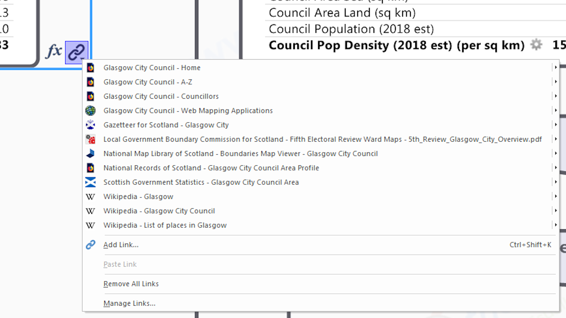
Multiple Hyperlinks On A Single Branch
MindManager has the unique ability to attach multiple hyperlinks to a single map branch. This means that…
1) maps need fewer branches so are less visually cluttered;
2) a single branch can become a mini knowledge portal in it’s own right;
3) links to core knowledge resources can remain with the branch when it’s re-used in other maps (whether or not it’s the key focus of that map).
4) a map with 1000’s of branches, can contain many more 1000’s of hyperlinks!

Embedded Single Data Cells ('Topic Properties')
Multiple data fields (akin to single cells in a spreadsheet) can be embedded within a branch and is another way of adding contextual facts & figures to the map. Also the field values can be used to visually format the individual branch eg. if the value is greater than a particular number then make the branch text / fill this colour, or this shape (this is equivelant to ‘thematic mapping’ in GIS)…

HTML Export
MindManager has the unique ability to export maps as HTML5 (.html) files. These retain all the content – and most of the interactivity – of the original eg. they can be interactively queried by filtering using index marker tags to hide / show / highlight the coresponding branches. And, just like any other html file, they can be…
1) viewed by anybody, in any modern internet browser (Chrome, Firefox, Safara etc.), on or offline (once downloaded), on any device;
2) shared by email or file sharing services (eg. DropBox);
3) published online as stand-alone web pages, such that they have their own URL (which can be shared), or even embedded within existing pages (and hosted somewhere else eg. the aforementioned URL).
This means that anybody can view the knowledge maps we create, they don’t need to have MindMaanger software (unless they want to amend or re-use the content).
Anyway as you can see MindManager software really does enable us to take knowledge mapping to the next level….
We seriously began using MindManager – the world’s best information mapping software – as a business information mapping tool back in 2002 (see above). However we soon realised that the MindManager maps we were now creating, and the geographic maps that we created and worked with every day (Knowledge Mappers started out as a consultancy offering geographic information mapping & spatial analysis services), had many characteristics in common….
Both are their own type of visual knowledge format
Maps are a type of visual knowledge format in their own right. By ‘visual knowledge’ we mean that they capture and encode data / information / knowledge within them as visual elements (‘pictures’ at their simplest) that convey said to the viewer visually rather than as text that they have to first understand the words of, and then interpret their meaning.
Sure you could use words to start describing a map, but you would soon tie yourself up in knots – where do you even start? Do you describe every ‘thing’, or just the most important ‘things’? Do you describe the relationships between ‘the thing’ and every ‘other thing’, or just the ‘adjacent things’ round about it? And is that description absolute in terms of distance, or relative in terms of position? And isn’t it just easier to draw a picture?
Both map 'the things' that together define 'a space'
At it’s simplest ‘a map’ is a visually structured index of what ‘things’ together define a particular ‘space’, and the inter-relationships between them within ‘the space’.
Geographic maps depict ‘geographic (ie. ‘real world’) space’ and the ‘geographic things’ that exist within it…
- Topographic features – these define the physical landscape within which we humand exist eg. rivers, coastlines, mountains, valleys, forests etc.),
- Human geographic features – these are all man-made and exist in the ‘real world’, but some are ‘physically tangible’ (eg. settlements, roads, fields etc.), whilst some just exist as ‘lines on a map’ and so are purely ‘conceptual’, even though they may be vital to the running of a human society (eg. administrative / electoral / public service delivery areas etc.).
In a MindManager map the space is always ‘conceptual’ (ie. it exists in our ‘brain space’), and the branches are the ‘things’ that define the ‘conceptual space’. Traditionally the ‘conceptual things’ in mindmaps are of an individual’s ‘thoughts’ and ‘ideas’ about a particular subject, however we realised that they was no reason why they couldn’t also be about ‘real world things’ – say the aforementioned ‘human geaographic things’.
*LIGHTBULB MOMENT*
Both map the relationships between 'the things' that together define 'the space'
Professionally produced geographic maps are a visual record of the recorded locations of ‘the geographic things’ within the mapped ‘geographic space’. Geographic locations can be defined in 2 ways, each of which in turn enable the spatial inter-relationships between ‘the things’ to be described in different ways…
- absolutely using numeric co-ordinate systems to locate them in at least 2 (if not 3) dimensional ‘real world’ space. This is what makes a ‘geographic map’ a true scale drawing of the geographic space, from which we can quantitavely answer queries like ‘how far apart are these 2 ‘point things’ from each other’, ‘how much do these 2 ‘area things’ overlap? etc.
- relatively with respect to each other, from which we can derive qualititative logical relationships like ‘beside’, ‘connected to’, ‘overlaps with’, ‘contained enirely within’, ‘is a sub-division of’ etc.
Where the relatively defined relationships between ‘the things’ within ‘a space’ are logical and hierarchical, they can also be captured in a MindManager map.
The classic logical tree diagram map for a ‘conceptual human space’ is an organisation chart, which shows the different divisions and sub-divisions of an organisation, and who is in charge of who. However it is surprising how often that the ‘things’ that make up our everyday ‘human geography space’ have hierachical inter-relationships. For example the ‘Countries of the World’ are arranged into macro geographic sub-regions and regions for official statistical purposes by the United Nations, whilst also being made up of sub-national divisions like states, counties and communities. It is through all these administrative areas that the afairs of the human race are usually organised and run…
*ANOTHER LIGHBULB MOMENT*
Both use cartographic principles and devices to create a visual structure & language
A map encodes & conveys information visually, but crucially does so in a logical, structured way using the art & science of cartography, which uses cartographic principles & devices such as….
- visual hierachies – more visually prominent things (bigger, bolder etc.) are more important.
- lines – can show relationships between things – equivelant to, subdivision of, border between etc.
- shapes – points, lines and areas (polygons) etc.
- symbols – these could be literal depictions or visual metaphors.
- colours – meaningful, eye-catching, complementary, contrasting etc.
All these are in conjunction with a minimal amount of text – which is usually in the form of brief labels of said points, lines and areas – which too are visually formatted using the same cartographic devices.
Together all these elements create a visually structured, cartographic framework (‘language’) of knowledge elements that…
- more actively engage with the viewers brains than a linearly structured, text-only knowledge resource does, and so it is more easily navigated, understood and assimilated (as per mindmapping principles – see above).
- can be replicated when creating other maps to establish a common visual knowledge framework & language for capturing and working with different sets of data / information / knowledge that occupy the same ‘conceptual space’ (which as we say could still be ‘real world space’).
Both can be built up in layers of related 'things'
Most of us at some point have taken a geographic map and drawn our own information on top of it to quickly transfer our geographic knowledge to others or for it to be transfered to us – eg. ‘the route’ for new friends to get to our house, or for us to get from the hotel we’ve never stayed in before to the museum we’ve never visited before. In the old days it was by drawing a line on a paper map, but Google Maps showing you the ‘routes’ between the 2 points as coloured lines on your mobile phone screen is still the same priniple.
And that principle is that the starting geographic map is acting as a ‘basemap’ knowledge layer upon which additional layers of more specialised knowledge (eg. ‘the route’) are added. These additional layers are proper ‘layers in the information system’ in their own right, but without the visual context provided by the underlying basemap layers (which place them in a bigger picture / real world space, that is familiar to the viewer) they would be difficult for a viewer to understand, especially without any exisiting ‘local knowledge’. For example ‘a route’ is just a line on a piece of paper (or screen) if it doesn’t reference ‘things’ in ‘geographic space’ – a starting location, a destination location and named roads in between.
Similarly we can think of each level in the branch hierarchy of a MindManager map as additional layers of ‘related things’, each building on the previous layer. This is the basis of our series of Countries of the World knowledge atlas maps (see below).
*ANOTHER LIGHTBULB MOMENT*
Both are physical - and therefore archivable - knowledge artefacts
Geographic maps have 2 lives…
- The first is as a ‘living / working document’ that shows ‘the space’ and the ‘things’ that define it ‘now’ (or at least the date of publication).
- However the world moves on, ‘things’ change, ‘spaces’ change, and so the maps of them have to be updated so that they still reflect the latest situation ‘in the real world’. It is then that the original map becomes a historical record of what ‘things’ made up ‘the space’ at that particular point in time.
In the age of paper geographic maps this cycle of ‘survey, publish and archive’ was usually infrequent, due to the expense of manual field survey methodoligies, but also the fact that the pace of change of the real world was not that fast. Superceded maps were physically archived in map libraries (just like the books in the rest of the library) so they could be still be available to future generations to consult.
However in the digital age the whole process happens much quicker. Field surveyors use digital tools and upload their data to a central spatial database there and then, where it may be augmented with data gathered using remote sensing techniques (from satellites, planes and drones). Online mapping services like Google Maps ‘assemble on demand’ the maps they display to the viewer from the objects in the spatial database, so they always ‘serve up’ the most current picture. Thus unless the underlying digital data is shared, a ‘Google Map’ isn’t a ‘map type artefact’ that can be archived.
By definition MindManger maps too are digital, however they are saved as a physical software file, which can be copied, stored locally and/or centraly, and archived.
In other words we could replicate ‘traditional maps of geographic space’ in a MindManager map – well at least it coud be a visually structured record of the ‘geographic things’ that define a single ‘geographic space’ along with the hierarchical relationships between them.

So we realised that it may be possible to use MindManager to map ‘geographic space’. Yes it would be in a more limited way compared to some aspects of a ‘traditional geographic map’, however we could use mindmapping principles and MindManager’s amazing ‘information cartography’ tools to take other aspects much, much further. For example…
- incorporating hyperlinks to multiple online, public domain knowledge resources about each of the ‘geographic things’ – be they ‘official’, ‘definitive’ or just ‘plain old useful’ 🙂 – by attaching them to the map branch that represents that ‘thing’.
- incorporating core contextual knowledge about each of the ‘geographic things’ – gleaned from those now linked to online resources – using MindManager’s many information cartography tools – embedded elements like images (such as geographic maps), spreadsheet tables & charts, and single data cells; and attached elements like notes and index marker tags.
That in fact we could create a knowledge atlas (ie. a knowledge map about real world geographic things)…

But how did we actually do it? How do we get from a ‘traditional geographic map of countries of the world’, to a ‘knowledge atlas of countries of the world’?
Well it’s all about those inter-relationships between the geographic building blocks (ie. the countries) that make up a space (ie. the world), as it is mapping these in MindManager that will create the fundamental, inter-connected framework of map branches.
But in order to do that, we need to know….
- What are all the ‘Countries of the World’ (each ‘country’ will be represented by one branch only in the map)?
- What are the hierarchical relationships between them (which will define how those branches are best arranged within the map)?
As we’ll see below, the answers to these are officially defined in downloadable data tables & spreadsheets, which can be easily imported into MindManager as a starting point….
ISO3166-1 - The definitive list of 'Countries of the World'

So it turns out the official list (or ‘register’) of the ‘Countries of the World’ is the international standard ISO3166 – ‘Codes for the representation of names of countries and their subdivisions’. This can be found on the International Standards Organisation (ISO)’s website, with the actual data table on the ISO online browing platform. (Though as ISO point out they are only responsible for maintaining the coding system of unique letters and/or numbers – so that countries and their subdivisions can be referred to in a completely unambiguous way that transcends language barriers – whilst the names come from official United Nations sources.)
UN Geoscheme - ISO3166-1 Countries grouped into Macro geographic regions & sub-regions

There are many ways of arranging the ‘Countiries of the World’ into related groups and sub-groups, but the main official (but not only) schema for grouping them together geographically into macro-geographic regions and sub-regions is the United Nations Geoscheme (or M49 Statistical Standard), devised by the UN to consistently collect and aggregate country based statistics to try and keep track of what’s going on in this big old crazy world of ours.
Thus it is the UN Geoscheme that officially defines the hierarchical inter-relationships between the official ‘Countries of the World’, and it’s those that our MindManager map will capture as a network of knowledge seed branches – one for each country, region and sub-region – inter-connected by relationship lines to create the hierarchy and so define ‘the space’.
And so now we’ve tracked down this definitive data source, we can get cracking….
Turning the Geoscheme data table into a basic MindManager map

Turning an existing data table into a map is where MindManager comes into it’s own, providing several ways of ‘getting it into the system’…
- Manual – highlight, drag and drop (or copy and paste) the data from the source into where you want it to go on the map (ideal for data capture ‘on the hoof’).
- Automated – import the spreadsheet or .csv file directly into MindManager with the Excel Mapping Tool (or link it to a database).
The choice is yours, but personally speaking, as with mindmapping, there’s nothing like the physical process of creating a knowledge map with your own hands to really improve your understanding of the subject, especially from a base knowledge of zero.
Anyway once that’s done, we now have our basic MindManager map – a ‘tree diagram’ network of branches (one for each country, region and sub-region), inter-connected by relationship lines to visually define the hierarchy.
So now that we have our basic MindManager map – a ‘tree diagram’ network of branches (one for each country, region and sub-region), inter-connected by relationship lines to visually define the hierarchy – how do we transform it into our Countries of the World Knowledge Atlas?
Turning the basic MindManager map into a Knowledge Atlas
So what does this basic MindManager map lack that we will have to add to create our Knowledge Atlas map? Well….
- Links to official / definitive / plain old useful multiple knowledge resources about each country, grouped into ‘collections’.
- Visual knowledge elements embedded / attached to the branches to add contextual knowledge and utility.
- Integration of all these together in country / region knowledge seed branches, each of which is a mini knowlkedge portal in it’s wn right.
- Everything tied together in a visually appealling but still structured way that ‘packs a lot in’ but doesn’t immediately overwhelm the user.
In other words what is required is a lot of detective work and application of cartographic ‘know how’….


Incorporating links to knowledge resources about the country / region into the map
In order to include links to official / definitive / plain old useful public domain knowledge resources about the ‘Countries of the World’ in our map, we first need to track them down ourselves wherever they are in the online public domain (what we call ‘going on a knowledge safari’ :-).
This may seem like a daunting task, but actually we’ve already ‘got one in the bag’ in the form of the original ISO online platform listing all the countries that are part of the ISO3166-1 standard, as each one has it’s own listing page (eg. this one for the United Kingdom of Great Britain and Northern Ireland).
And as we’ve said, the GeoScheme schema was devised by the United Nations for country-level data gathering, so it’s no surpirse that each country and region has a data page on the UNdata portal – so that’s 2 knowledge resource links. (Actually it’s quite a lot more as once you look deeper you will find they also have pages on the websites of many of the UN family of organisations, but that’s for later :-).
And then of course there’s Wikipedia, because in this day and age just about everything important has it’s own page (or even it’s own category) on Wikipedia (the corollary being if it’s not on Wikipedia, is it even important? – discuss ;-)….
And then there’s all the external links referenced to in the Wikipedia page….
And possibly sister sites to Wikipedia, like the Wikivoyage site for travellers….
And then there’s all the ones we can find with a browser and a Google search bar (other search engines are available ;-)….
Of course before they’re added to the final map all these links have to be….
- assessed for quality before adding.
- ‘tidied up’ and cartographically improved after adding.
- arranged into logical collections (eg. ‘General knowledge’, ‘Geographic knowledge’ etc.)
However once that is done…
- we can explore them ourselves to find useful contextual knowledge to incorporate within the map (which in turn might lead to more knowledge resources to include).
- for the end user they become both more easily discoverable within the ‘bigger picture’ context of the whole map, and more easily accessible as they are only ever no more than a couple of mouse clicks away.
Thus as well as being a visually structured index of knowledge resources about the ‘things’ in the ‘space’, our knowledge map is now also a portal to those resources.

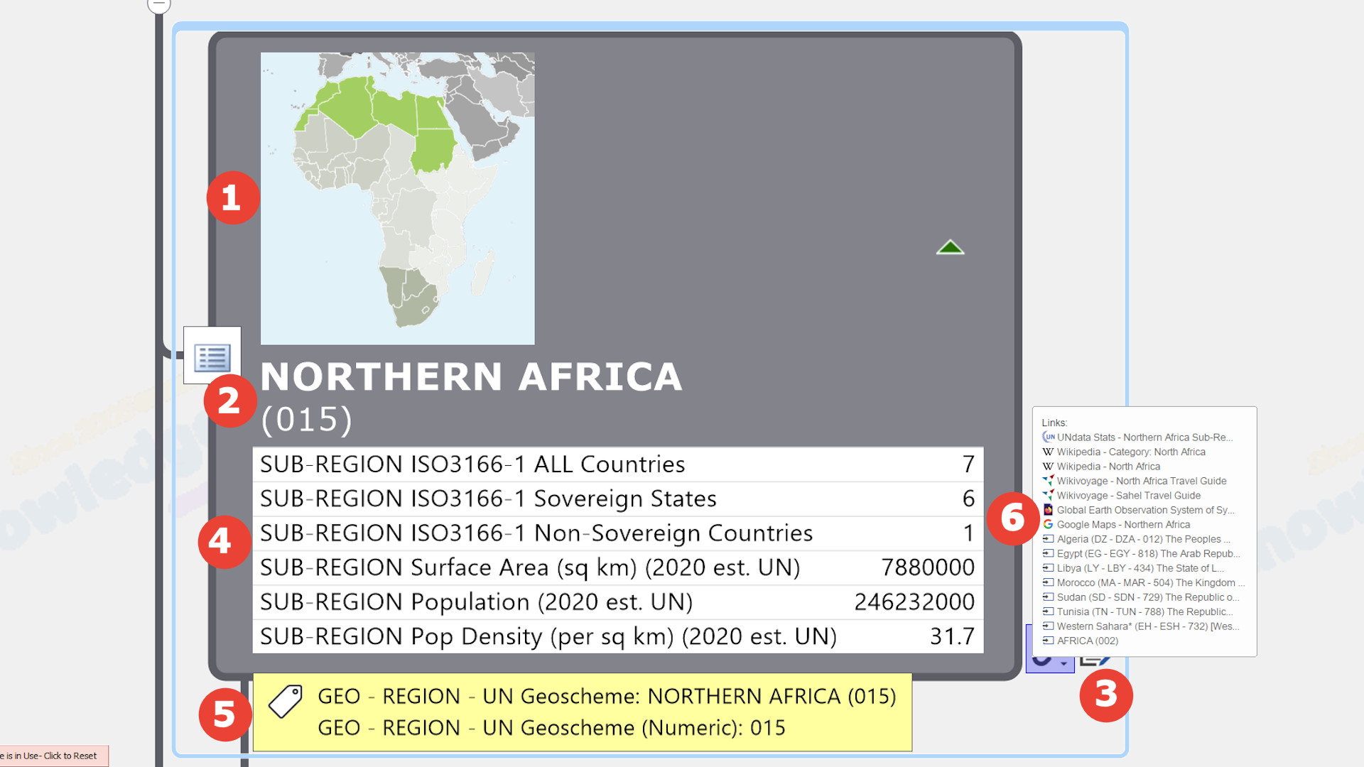

Incorporating contextual knowledge gleaned from the 'linked to' resources as visual knowledge elements
Using MindManager’s many unique ‘information cartography’ features (see above), some of the core information contained in the linked to resources could be embedded within, or attached to, the indiividual seed branches in the map as one or more knowledge elements….
![]() Outline Shape – This may convey knowledge about some aspect of the subject of the branch. For example for branches representing geographic areas, the outline shape indicates the nature of its’ borders with neighbouring areas with respect to the sea…
Outline Shape – This may convey knowledge about some aspect of the subject of the branch. For example for branches representing geographic areas, the outline shape indicates the nature of its’ borders with neighbouring areas with respect to the sea…
![]() CIRCLE = all coastal borders (ie. ‘island(s)’)
CIRCLE = all coastal borders (ie. ‘island(s)’)
![]() HEXAGON = all land borders (ie. ‘land-locked’)
HEXAGON = all land borders (ie. ‘land-locked’)
![]() ROUNDED RECTANGLE = mixed coastal & Land borders
ROUNDED RECTANGLE = mixed coastal & Land borders
![]() Fill Colour – Sometimes the colour filling a branch conveys knowledge eg. a particular political party.
Fill Colour – Sometimes the colour filling a branch conveys knowledge eg. a particular political party.
![]() Image [Embedded] – Images provide a unique visual element that users can instantly ‘latch onto’ as they navigate their way around the map. So such things as….
Image [Embedded] – Images provide a unique visual element that users can instantly ‘latch onto’ as they navigate their way around the map. So such things as….
- screenshots of actual geographic maps (eg.thumbnail location maps),
- flags
- icons
- people (eg. profile pictures)
- logos
- etc.
![]() Text – Thanks to MindManager’s unique ability to handle ‘rich’ text – the ability to variably format individual chatracters within a single text ‘string’ – we can pack several different pieces of ‘core knowledge’ – such as names & unique identifying codes (taken from official sources) – into the text of a single branch without it visually overwhelming the user.
Text – Thanks to MindManager’s unique ability to handle ‘rich’ text – the ability to variably format individual chatracters within a single text ‘string’ – we can pack several different pieces of ‘core knowledge’ – such as names & unique identifying codes (taken from official sources) – into the text of a single branch without it visually overwhelming the user.
![]() Note [Attached] – A branch note can contain all the elements of a word processed page – variably formatted (‘rich’) text, links, tables and images, and so is an ideal place for supplementary information that would otherwise add visual clutter to the map.
Note [Attached] – A branch note can contain all the elements of a word processed page – variably formatted (‘rich’) text, links, tables and images, and so is an ideal place for supplementary information that would otherwise add visual clutter to the map.
Data Elements [Embedded] – MindManager has 2 unique ways to add contextual ‘facts & figures’ (i.e. text and number fields) to individual branches so that they are visible to the user (though only one can be used on any given branch at one time)…
![]() Spreadsheet Table / Chart – A branch specific spreadsheet table created using MindManager’s spreadshet tool (i.e. not referencing cells in a ‘normal’ spreadsheet file stored elsewhere), with all the usual functionality available. If the data content is structured appropriately, it can be toggled between ‘table’ and ‘chart’ view (though this view is ‘fixed’ when the map is exported to create the HTML version).
Spreadsheet Table / Chart – A branch specific spreadsheet table created using MindManager’s spreadshet tool (i.e. not referencing cells in a ‘normal’ spreadsheet file stored elsewhere), with all the usual functionality available. If the data content is structured appropriately, it can be toggled between ‘table’ and ‘chart’ view (though this view is ‘fixed’ when the map is exported to create the HTML version).
![]() Multiple Single Data Fields – These are like single cells in a spreadsheet and the values – which can be text or numeric – can be used to visually format the branch using MindManager’s Smart Rules feature.
Multiple Single Data Fields – These are like single cells in a spreadsheet and the values – which can be text or numeric – can be used to visually format the branch using MindManager’s Smart Rules feature.
![]() Index Marker Tags [Attached] – Arranged in groups and added to individual branches as appropriate, index marker tags add visible contextual knowledge, enable map filtering to show / hide only those branches with specified tags, and enable internal map navigation.
Index Marker Tags [Attached] – Arranged in groups and added to individual branches as appropriate, index marker tags add visible contextual knowledge, enable map filtering to show / hide only those branches with specified tags, and enable internal map navigation.
![]() Multiple Hyperlinks [Attached] – Another unique feature, multiple links to a range of official / definitive / plain old useful knowledge resources attached to the seed branch – usually selected from the full range of general & geographic knowledge resource collections – help turn the map into a knowledge portal without adding to the visual clutter.
Multiple Hyperlinks [Attached] – Another unique feature, multiple links to a range of official / definitive / plain old useful knowledge resources attached to the seed branch – usually selected from the full range of general & geographic knowledge resource collections – help turn the map into a knowledge portal without adding to the visual clutter.
In practice these processes are not sequential but organically iterative – one feeds into the other, which then feeds back into that and so it goes on (like the Mindmapping process described earlier, but unlike that it is constrained by what is actually out there in the real world).
Anyway we hope you agree that the sum of the whole is greater than the sum of the individual parts 🙂
You can find out more about the details of the knowledge map making process in the ‘About – The Process’ section of this website.

Intrigued, we applied the same technique to the humble calendar – the atlas for ‘time space’ – and, to cut a slightly shorter research & development story short – our calendar knowledge maps were born…
(These also crossed over to the ‘geographic space’ when we added links to the national days of every country of the world, as well as calendars for specific countries…)
Thinking further we realised there’s plenty of ‘things’ in the world of human endeavour that are real, and important, and have hierarchical (and other) inter-relationship with other real, and important, things….
- organisations from governments (national to local) and public bodies, to corporations to community groups, to informal networks
- in fact networks, people and organisations of any type and the ‘spaces’, economic spaces. Such spaces can’t be mapped geographically, or even if they can, mapping them only geographically doesn’t add much to our practical knowledge about them. An ‘organisation map’ is an obvious example of such a non-geographic knowledge map.
In fact we soon realised that, using this new visual mapping technique , we could map pretty much capture any ‘space’ of human interest and endeavour – be it physical, virtual, conceptual or whatever – as a MindManager map…

In these days of information overload we also realised that our knowledge maps could help people – and the teams, organisations and communities of which they are part – more quickly and easily answer the basic questions about ‘the spaces’ that they spend a lot of their time & resources trying to find answers to…
- What are the important ‘things’ that make up this ‘space’ we are interested in?
- What is the ‘spatial’ / hierarchical relationship between them?
- What do we know about them?
- Where are those knowledge resources to be found?
- How do we access them now – and in the future – so we can use them to benefit our organisation / community / project?
By discovering & accessing the knowledge they need more quickly (and with a lot less stress :-), they could spend their precious (and usually limited) time & resources actually utilisng it to do what they need to do, rather than scrolling through endless search results (assuming they knew what to look for in the first place of course).
Anybody with access to MindManager software can use our knowledge maps as ‘ready made’ templates to amend, adapt & repurpose (in whole or in part) in their own projects, so they do not have to re-invent the knowledge wheel each time.
However thanks to MindManager’s unique HTML export capabilities, the HTML versions of our knowledge maps can be accessed by anybody using any modern browser, on any device, on or offline, without the need for any plugins ie. everybody!
And so we opened our digital download map store so that anybody can benefit from the ‘universdally useful’ knowledge maps of our world we create, and began offering our knowledge mapping services to map ‘spaces’ on behalf of clients as well as help them to do it for themselves…
Map Facts
Here are some of the ‘fun facts’ 😉 about Scotland’s 354 Local Council Electoral Wards that we have discovered (and embedded!) during the process of creating this map…
Geographic Area
Smallest & Largest
Hillhead Ward [Glasgow City Council]
Wester Ross, Strathpeffer and Lochalsh Ward [Highland Council]
Population (2018 Est)
Smallest & Largest
Lerwick North Ward [Shetland Islands Council]
Southside/Newington Ward [City of Edinburgh Council]
Population Density
Smallest & Largest
North, West and Central Sutherland Ward [Highland Council]
Hillhead Ward [Glasgow City Council]
Borders With Neighbouring Electoral Wards
With respect to land & sea
All Coastal Borders
(ie. 'Islands')
Land & Coastal Borders
(ie. 'Mixed')
All Land Borders
(ie. 'Land-Locked')
Map Features
We take full advantage of MindManager’s many unique ‘information cartography’ features when creating our unique maps so we can pack in 1000’s of ‘bits’ of knowledge into a single, visually structured, intuitive to navigate document that can be easily shared. Here are the main features of this Scottish Local Council Electoral Wards General & Geographic Knowledge Atlas (30 Sep 2019) …

Big Map With 1000's Of Branches & Links And Capacity For Plenty More
With 6,514 knowledge resource links over 4,968 branches, this map is a useful, contextual knowledge resource in it’s own right, as well as being a visually structured index of the best definitive / official / plain old useful knowledge resources available in the public domain about Scotland’s 354 Local Council Electoral Wards. Thanks to MindManager’s unique capabilities it has plenty of spare capacity for further content to be added in the future, or re-purposed as a basis for other maps.

Main Branches Create Robust Visual Framework For 'Seed Branches'
The 1st level branches form the main (‘org-tree’) visual framework within which the map content of interest sits. It is a simple ‘A – Z’ layout, with the 32 Scottish Local Councils arranged alphabetically in 5 columns of approximately equal sizes to pack as much in to a ‘single screen view’ as possible.
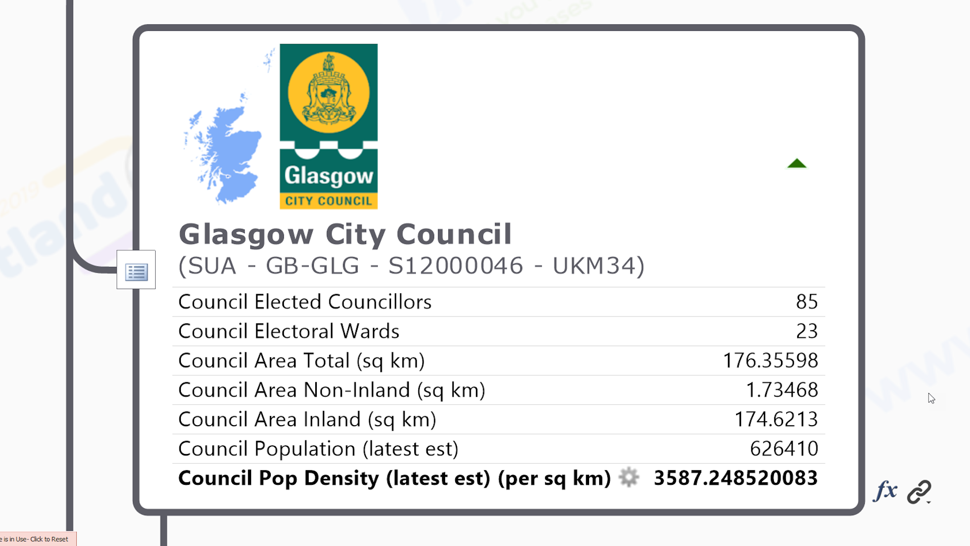
Visually Rich 'Knowledge Seed' Branch For Every Scottish Local Council
The 2nd level branches are ‘knowledge seed points’ for each Scottish Local Council, to which links to public domain knowledge resources about them are attached. Visually rich & information dense, they contain the name & official area identifier codes in variably formatted (‘rich’) text – a unique MindManager featue. Visually the combined logo & thumbnail location map image aids user navigation and provides spatial context, whilst the variation in topic shape indicates the status of the borders with neighbouring councils – all coastlal (ie. island), mixed or all land (ie. landlocked). The full list of visual knowledge embedded within this seed topic is given in the map summary above.
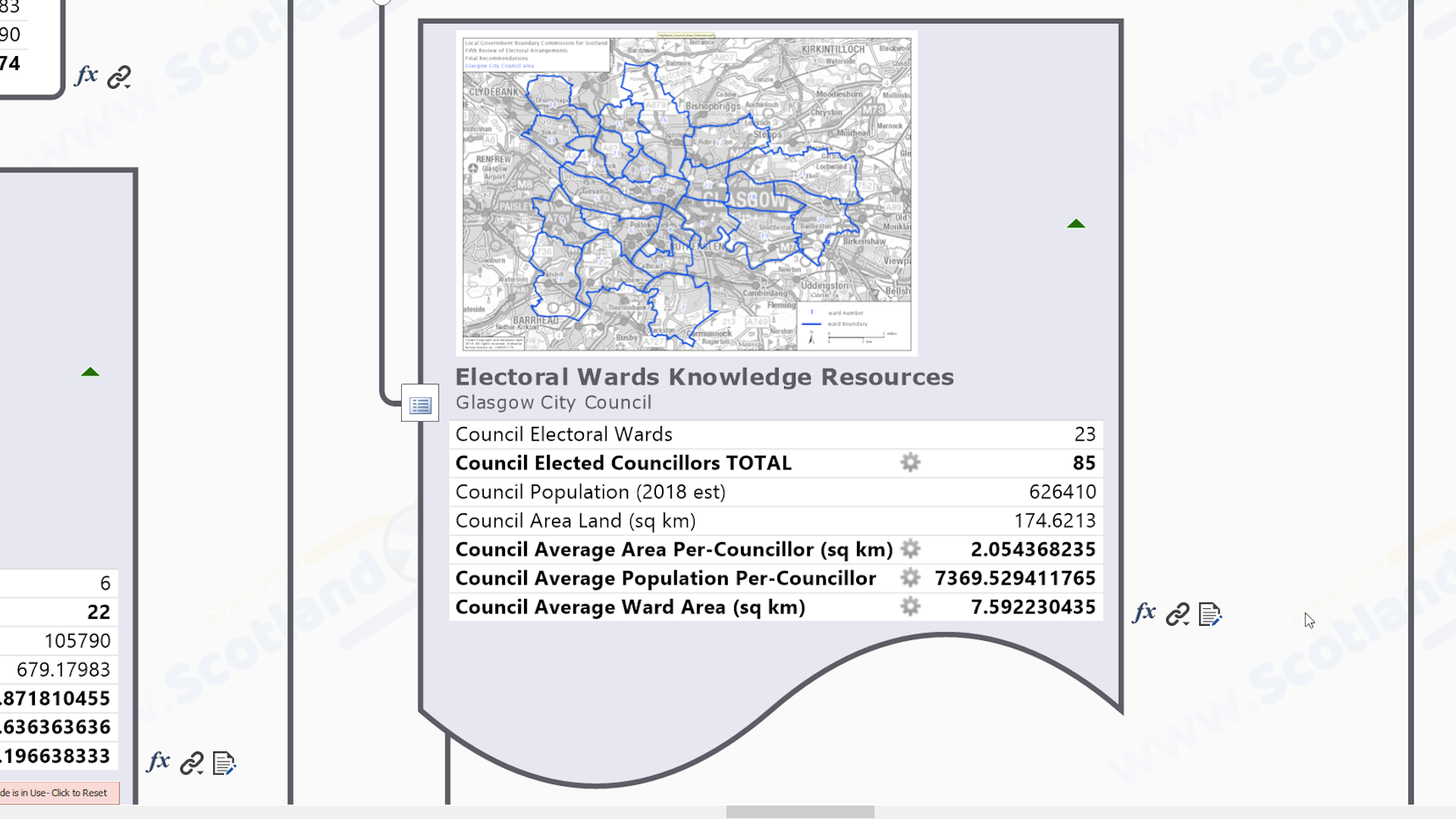
Visually Rich 'Knowledge Seed' Branch For All Electoral Wards In The Local Council
The 3rd level branches are ‘knowledge seed points’ for the electoral wards that make up the Local Council, both as a whole and individually. Visually rich & information dense, they contain a good quality thumbnail image (ie. still readable & usable when zoomed in) of the official Local Government Boundary Commission ward overview map to provide spatial context. Embedded data fields – many of them autocalculated and not available elsewhere in the public domain – give geodemographic context. There are also multiple hyperlinks to public domain knowledge resources about the wards as a whole. The full list of knowledge embedded within, and attached to, this seed topic is given in the map summary above.

Whole Council & Individual Ward Knowledge Resource Sub-branch Collections
Knowledge resources about the council’s electoral wards are split into 2 sub-collections at ‘Whole Council’ and ‘Individual’ level.
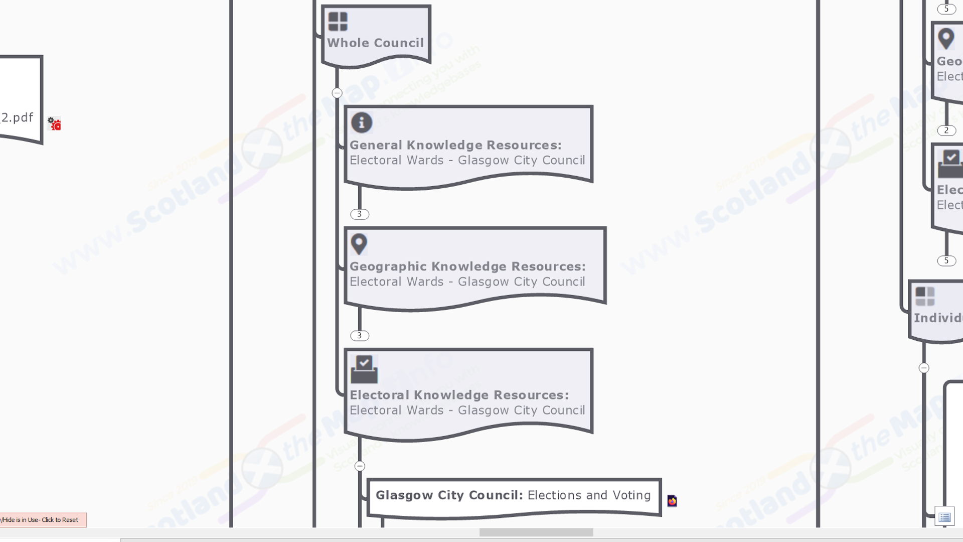
General, Geographic & Electoral Knowledge Resource Collections For All Wards As A Whole
The Council Electoral Wards as a whole sub-branch collections – each with a single hyperlink to official / definitive / at least practical & useful online knowledge resources – are grouped into related collections for ‘general’, ‘geographic’ and ‘electoral’ knowledge resources. These are starting points for knowledge discovery and subsequent more detailed (‘desktop’) research. (MindManager software users have the advantage of being able to add to these branches as they go). The full list of links in the sub-branch collections attached to this seed branch is given in the map summary above.
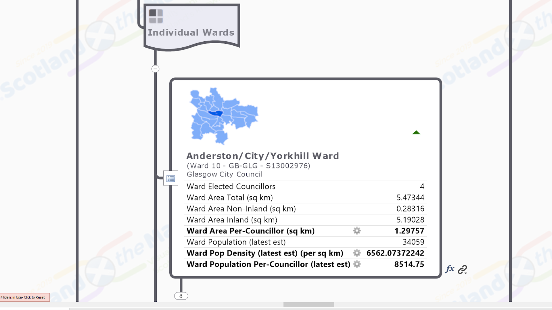
Visually Rich 'Knowledge Seed' Branch For Each Of Scotland's 354 Electoral Wards
As for the ‘Local Council’, the seed branches for each individual ward are a visually rich mixture of embedded and attached knowledge. They contain the name & official ward identifier codes in variably formatted (‘rich’) text, a thumbnail location map image aids user navigation and provides spatial context, aided by the variation in topic shape indicating the status of the borders with neighbouring councils – all coastlal (ie. island), mixed or all land (ie. landlocked. The data fields – many of them autocalculated and not available elsewhere in the public domain – provide geodemographic context, supplemented by the topic shape, which indicates the status of the borders with neighbouring councils – all coastlal (ie. island), mixed or all land (ie. landlocked). There are also multiple hyperlinks to the public domain general, geographic & electoral knowledge resources. The full list of knowledge embedded within, and attached to, this seed topic is given in the map summary above.
General, Geographic & Electoral Knowledge Resource Collections For Each Individual Ward
The sub-branch collections for each individual Electoral Ward is the same as those for all wards as a whole – ‘general’, ‘geographic’ and ‘electoral’ knowledge resources. The full list of links in the sub-branch collections attached to this seed branch is given in the map summary above.
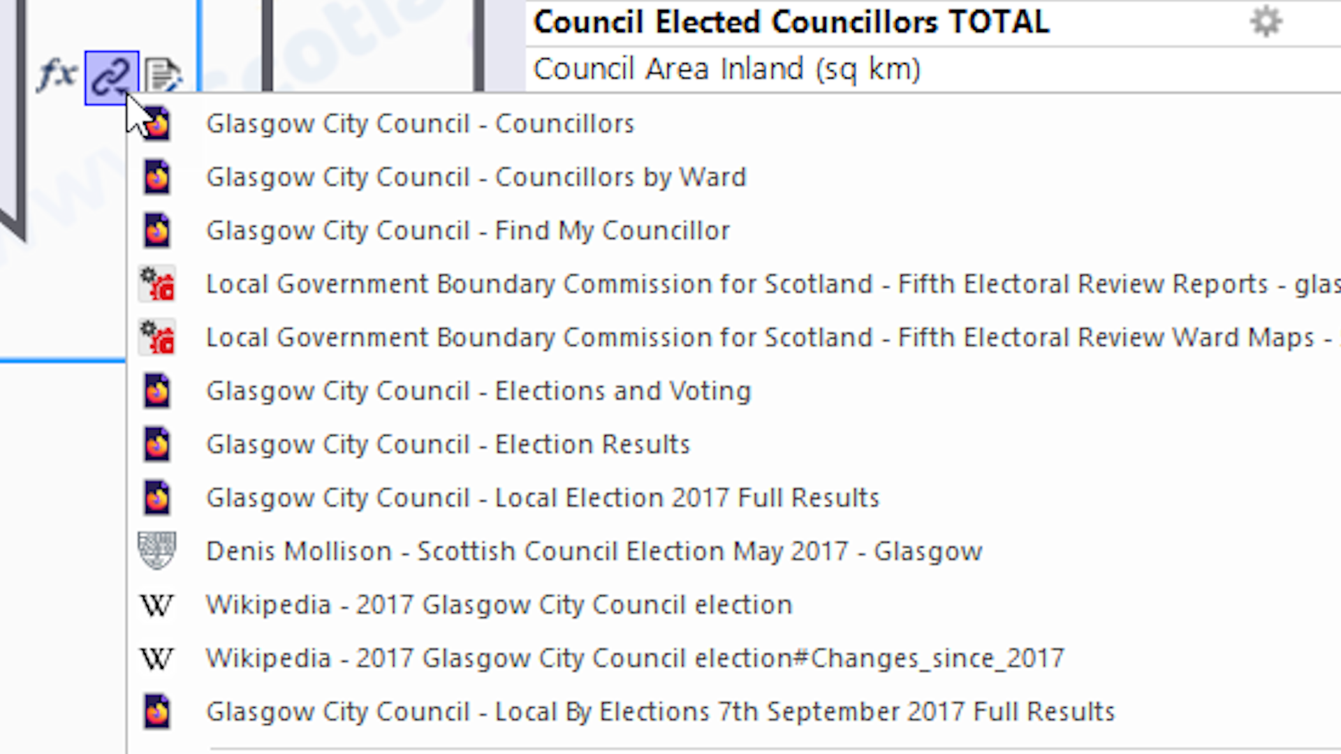
Attached Multiple Hyperlinks To Public Domain Knowledge Resources
Seed Branches have multiple hyperlinks attached to them (yet another unique feature of MindManager maps), which link to the best definitive / official / plain old useful knowledge resources available in the public domain about the subject. The ‘definable link text’ gives clarty as to the resource being linked to (which can be very variable if left to the default). As well as increasing the amount of knowledge that can be ‘squeezed’ into a map without increasing the ‘visual clutter’ of additional branches, it means these links can be retained if the seed branches are used in other maps, or this map is re-purposed. The full list of multiple knowledge resource hyperlinks attached to all the seed topics in this map is given in the map summary above.

Index Marker Tag Groups Enable 'Geo Intelligent' & Other Map Filtering
Branches in the map may be tagged with one or more ‘index markers’ from one or more ‘marker groups’. These enable intelligent map filtering and quick navigation. Many of the tags are ‘geographic’ in nature such that branches are tagged with ‘where’ they are – eg. administrative or electoral areas. This gives the map in-built ‘spatial intelligence’ and the ability to be ‘geo-filtered’. (MindManager software users can copy and paste any of the marker groups in any other maps). The full list of index marker tags attached to all the seed topics in this map is given in the map summary above.

Embedded Data Elements Provide Additional Contextual Knowledge
Data features embedded within seed branches – like spreadsheets, charts & data fields (another unique MindManager feature) – provide another ‘channel’ of knowlegde that adds context to the more detailed knowledge contained in the public domain resources linked to in the map. Just like in a normal spreadsheet, some of the data field values may be ‘auto-calculated’ from the others using formulae, creating data not found elsewhere in the public domain. They can also be used to ‘conditionally format’ the map eg. colouring the branches based on a particular data value (the equivelant of ‘thematic mapping’ in GIS). The full list of data embedded within all the seed topics in this map is given in the map summary above.
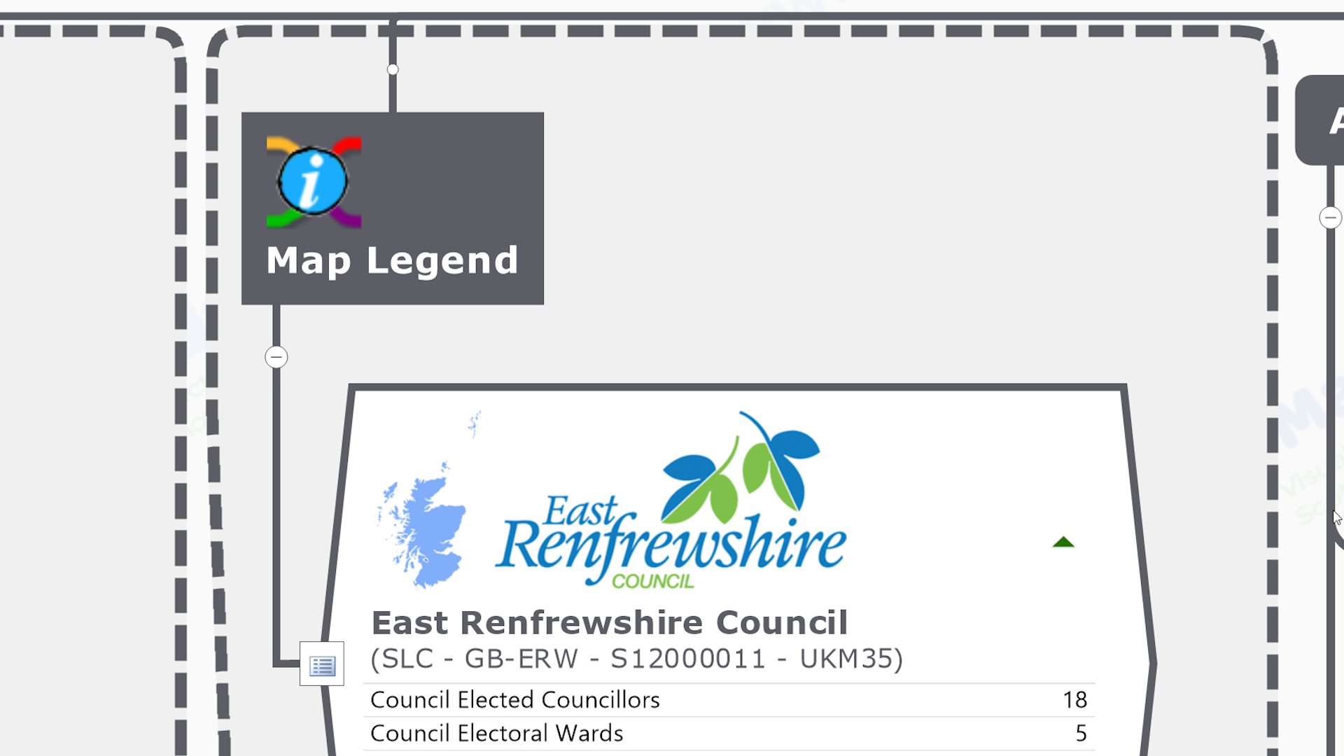
Map Legend Branch Describes Each Topic 'Type' With Links To Further Information
Every map needs to have a legend that explains the cartographic structure, colours and symbology used. The ‘Map Legend’ branch describes the sub-components of each ‘type’ of map branch, with links to further knowledge resources where necessary.
'Contributing Online Knowledge-bases Branch' With Links To Further Information
We hunt down and assess many official / definitive / at least practical & useful online knowledge resources in the process of creating our maps. The ‘Contributing Online Knowledge-bases’ branch has links to all the ones that are actually linked to in the main map content, as well as some others that are a good source of general knowledge about the subject. It is a frustrating fact of life that some resources are organised better than others, and not all are ‘linkable to’ at the individual ‘building block’ level and so can’t be included in seed branches.

Built-in Topic Styles Enable Quick Visual Reformatting
The visual formatting of all the map elements is controlled via our structured system of topic styles, which makes for easier alteration ‘on the hoof’ and therefore quicker map building. (MindManager software users can change the appearance of the whole map with just a few clicks eg. to match their own ‘in-house’ style & branding.)