Angus McDonald
Scotland The Map Project Director and Knowledge Mappers Founder & CEO


Cartography is the art and science of capturing and encoding information in a way that can effectively communicate it to viewers visually, instead of relying on an intellectual understanding of words – usually arranged to form a linear narrative of sentences and paragaraphs and chapters – on their own. Traditionally it is thought of in terms of geographic maps – visually structured knowledge about real things in the real world – but cartographic principles can equally be applied to any visually structured information, such as our knowledge maps.

1. Begin the cartographic process by introducing visual styling, such as variable text formatting to emphasise the most important elements. Shapes can also be used to encode information about the subject. For instance the shapes of a geographic area branch in our maps can indicate the nature of it’s boundaries with adjacent areas – all land (ie. ‘land-locked’), all coastal (ie. ‘island’), or mixed.

2. Add further contextual text to help the user, such as additional identifying codes if appropriate. These may be added incrementally as more knowledge resources are tapped.

3. Add a visual element (or combination) that is unique to that block such as a logo and / or thumbnail location maps. These engage a different part of the brain from plain text, and so greatly enhance user understanding of what the map is about, and provide signposts to navigate around it.

4. Visually embed additional knowledge, especially ‘facts & figures’ data, for handy reference and to add context. This could be in the form of a spreadsheet or a chart, or single data fields. Such data is often to be found in the same official statistics sources as the register. Obviously what data you choose to embed will be depend on the intended use of the map, but a starting point for us is general geo-statistics like physical size, area, population etc. Visual formatting of elements of the map, such as shape and text or fill colour, can be done automatically according to data values.
Note – Usually the whole cartographic process is an iterative one, with enhancements incrementally added as more knowledge resources are tapped. It may be revisited entirely if the map is repurposed.
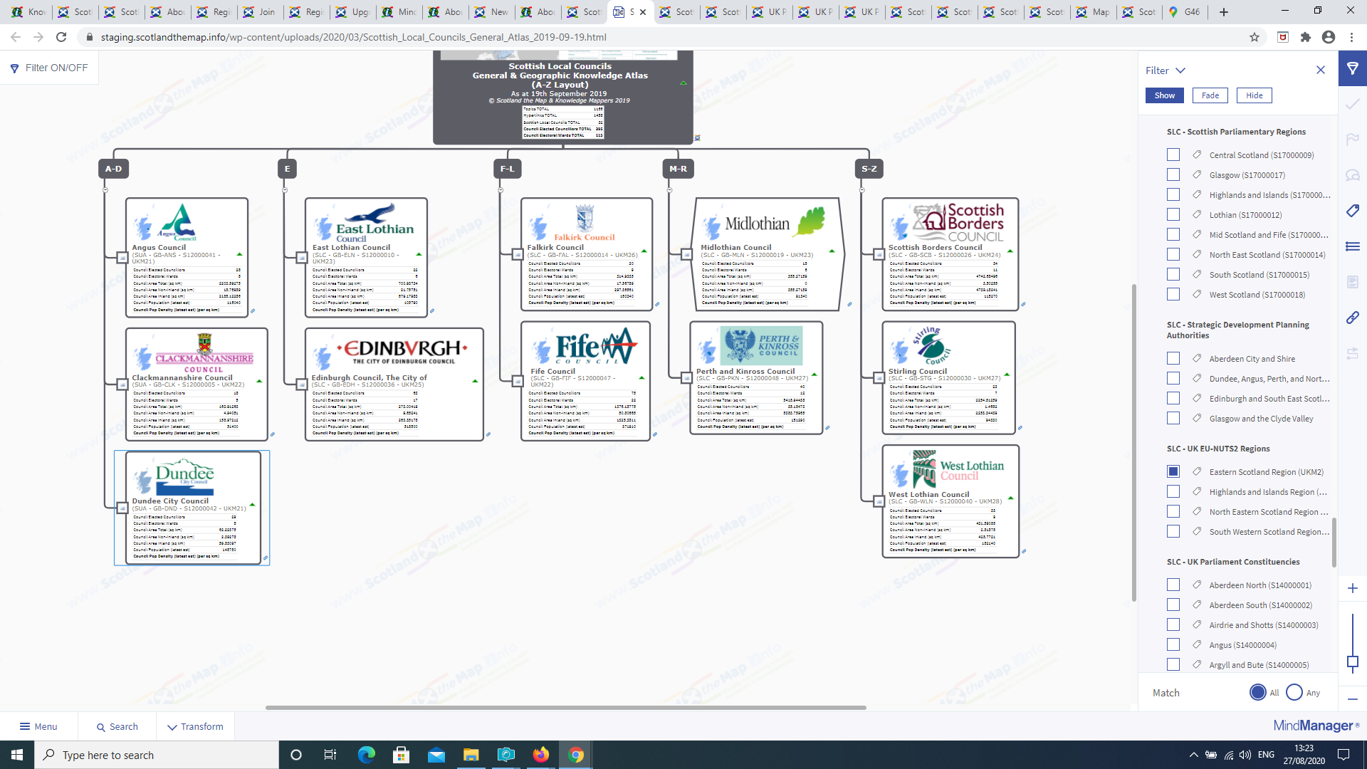
So now we have our cartographically enhanced seed branches arranged in a simple A-Z list, we need to re-arrange them to form the main knowledge framework of the map. With MindManager we have a range of possible layouts to choose from…

MindManager software was created in the early 1990’s out of a desire to be able to do mindmapping – a manual ‘pen and paper’ technique of creating radiating tree diagrams to aid thinking, learning & knowledge retention, popularised in the 1970’s by Tony Buzan – on a computer. As you can read on the Knowledge Mappers website – and see in the new map layout options screenshot above – MindManager has moved on a lot since that initial concept…
The main aspect of these developments that is relevant to our knowledge maps is that…
- Several layout choices – MindManager supports other radiating tree layouts in addition to the ‘radiating from the centre in all directions’ of ‘traditional’ mindmaps – right / left only, up / down ‘Org Charts’, single / double sided downward trees, horizontal / vertical timelines – as well as other visual diagram structures like organisational diagrams, process maps, concept maps, swim lanes etc.
- Even at individual branch level – This flexibility extends to individual map branches, where the layout of sub-branches can be varied to suit the particular contents (to make every map a unique combination of branch layouts).
- Designed for ease of lookup – With our knowledge maps the map is being used as a static, reference look up in the first instance rather than an iterative thinking tool, so the dynamics of the information flow between the visual map and viewer is different (but the idea of hierarchical structure is still fundamentally integral to the process).

Physical Structure Of Main Branch Framework – Through a lot of experimentation over the years we have settled on an ‘org-tree’ layout for our knowledge maps – a combination of an organisation chart for the main framework, and vertical trees for sub-branches. This has the advantage of…
- Filling the whole screen with visually rich knowledge branches – The ‘traditional’ mindmap layout leaves a lot of ‘white space’ between branches.
- Branches expanding in a vertically downwards direction only – In the ‘traditional’ mindmap layout branches move horizontally as well as vertically up and down on the screen when they are expanded, and all that sudden shifting around can be disorientatating to the user.
- Near familiar ‘pseudo grid’ layout – At first glance the ‘org-tree’ layout resembles a grid, silmilar to the interface of the online task management & collaboration tools that now have become a standard way of working for many (eg. Basecamp, Trello etc.), so it’s a bit of a ‘half way house’ compared to the traditional mindmap layout, which can be disorientating and a bit of a barrier to entry for visual working for many if presented with it out of the blue.
Logical Structure Of Main Branch Framework – So the main branch framework determines the physical structure of the map layout, but what of the logic of the arrangement of the seed branches within it? This needs to fit in with the ways we humans structure the world in our heads in order to break it down into manageable chunks so we can make sense of it…
- Alphabetically – The simplest logic, but at the mercy of the semantics of naming the branches in the first place. For example there is a Scottish Local Council that calls itself ‘The City of Edinburgh Council’ – should it be listed under ‘T’, or ‘C’ (‘City of Edinburgh Council, The’) or ‘E’ (Edinburgh Council, The City of’)?
- Geographically – The hierarchical nature of administrative / electoral geographic areas lends itself well to our hierarchical branch structure, especially if thumbnail images of geographic maps are embedded in the seed branches at the different levels.
- Chronologically – Again the hierarchical subdivisions of time into days, weeks, months and years lends itself well to our maps. It works well for published resources where arranging by publication date is often the quickest way to map them inititally until a more subject specific layout suggests itself.
- Combination – More than one logical structure can be used at a time, such as A-Z within geographic hierarchical areas.
The ‘Ideal’ Layout – So the aim is to fill the width of the screen with visual knowledge, whilst minimising the amount of horizontal / vertical scrolling required by the user. In an ideal world we would aim for 6 – 8 ‘columns’ of branches in total, which includes 2 for the ‘Map Legend’ and ‘Contributing Online Knowledge-bases’ branches. However it’s not an exact science as we are dealing with mapping the real world, which is not under our control. It all depends on the total number of building blocks that have to be included in the map, and how neatly they break down to fit the logical categorisation we are imposing on them.
For example there are quite a few Local Council names that start with the letter ‘E’ so it gets it’s own branch in our alphabetically arranged Local Councils map (and any other maps which use it as a base).

Map Filtering & Layout – The ability to filter maps – ie. hide or show branches – using index marker tags attached to them makes the initial choice of logical layout less crucial. Indeed the simpler the logic, the more flexible the map. For example there is no single, commonly used, but completely unambiguous, way of grouping Scottish Local Councils by geographic area eg. Dundee City Council is in the North East Electoral Region of the Scottish Parliament, but the ‘Eastern Scotland’ NUTS2 (European Union statistical) region. Thus we have chosen the simple A-Z layout which can then be filtered using geographic tags (a process called ‘geo’ filtering, commonly done in dedicated Geographic Information Systems).

In order for a knowledge resource about an individual building block to be included in the map, it will have to fulfil the following criteria…
It exists online – This usually means a website as a whole, or a page on a website, but could be a downloadable file (in which case the link to the file download page will also be included).
It’s definitive / official – As with the the definitive lists of the national building blocks used as a source to create the initial visual framework of knowledge seed branches, the starting point for knowledge resources about them must always be the official sources (the apposite phrase is “straight from the horses mouth”). However it can be surprising just how little depth and breadth of knowlegde some official sources contain. We will still need to include them so that gaps in official knowledge-base can be shown up, but it is for that reason that our main criteria is that the knowledge resources are…
…or just plain old useful – That is what we’re after at the end of the end of the day, knowledge that we can use. Depending on the subject matter there may be other professional – or enthusiastic amateur – experts that choose to share their knowledge freely online, so who are we to ignore it? This may be using their own website, or collaboratively on Wikipedia (see next section).
It’s ‘national local’ – A map covers all building blocks of a particular type in Scotland so in the first instance we are looking for knowledge resources that do the same, or are equivelants of each other. For example Wikipedia has an article on every Scottish Local Council so that could be considered as a single ‘national, local’ source. However each council will also have their own website on which they officially publish their own information, and whilst they cover the same range of subjects (as every council has the same responsibilities) and have similar features (an ‘A-Z of Services’ page, ‘Directory of Local Councillors’ etc.), they vary in how they do it (and therefore what is ‘linkable’), and the breadth and depth of the actual content.
It’s freely available in the public domain – This means it is free to access (ie. no subscription paywalls), and doesn’t involve downloading any 3rd party plugins.
It can actually be linked to – This means they have an individual web address ie. a URL, which unfortunately is not always as straightforward as we would hope. Over the last few years there has been an explosion in tools & widgets available to all web designers (whether professional or amateur) to make great looking pages with interactive, dynamically generated content. However just because the content of the page may change after you click something – say selecting the individual building block from a drop-down menu or list – it doesn’t now follow that the URL (as displayed in the browser address bar) will also change. If it doesn’t, it means that the specific content about the specific building block cannot be linked to externally. In these circumstances the best we can do in terms of capturing the knowledge resource in the map, is link to the page with instructions in the topic note on how to access the knowledge resource about the individual building block.

Our approach to making knowledge maps is the same as if we were making geographic maps. You start off with a basemap (like an Ordnance Survey or Google map) that visually shows all the building blocks and puts them in general, spatial context – where they are in the world but also the spatial relationships between them. Then you add the more specialisied information that you want your map to specifically show as another layer ‘on top’…
General Knowledge Resources – An obvious example would be an online encyclopedia like Wikipedia. When it comes to ‘official’ general knowledge resources about most types of building blocks however, there’s usually not an equivelant, single source of truth. For example for administrative / electoral areas, general (ie. contextal) knowledge ‘facts & figures’ are spread across resources on the Scottish Government Staistics, the National Records Office and Scotland’s Census websites for the Scottish Government, and the UK Government’s Office of National Statistics (ONS) website. However even they don’t have all the basic stats you would want (eg. geographic size), about every building block you would want (Community Councils anyone?).

Geographic Knowledge Resources – Basically maps, but also other resources based on location / place such as gazeteers. As Geographic Information professionals of many years, we understand their value as a fundamental type of knowledge resource in their own right, and the amount of effort and dedication that goes into making them. However with advances in technology they come in a range of digital forms, which vary greatly in their interactivity and – most importantly for adding to our knowledge maps – linkability…
- Static Geographic Maps – Despite the dominance of online platforms like Google maps et al, traditional ‘static’ maps of national local building blocks are still published to the public domain as downloadable files – usually PDF but sometimes in image file format. These could be a simple location map, or to accurately show boundaries. For example the Local Government Boundary Commission For Scotland publish official, definitive boundary maps of councils, electoral wards and Scottish Parliament Electoral Regions and constituencies as downloadable PDF files, designed to be printed at A4 size (ie on a standard office printer). These sort of digital map files are usually straightforward to link to in our maps, but they can also be incorporated as embedded images in seed branches to improve the contextual knowledge for the user.
- Interactive Geographic Map Platforms – Google Maps ‘changed the game’ for opening up access to geographic maps online 20 years ago, with the ‘slippy map’. As features have been added – satelite imagery, driving directions, Street View, 3D viewing etc. – they rapidly became mainstream too for users. There are now also other mapping platforms & tools available to organisations & individuals that enable them to publish and freely share their geographic knowledge online. For example as well as the ‘ststic maps’ the Local Government Boundary Commission For Scotland also hosts an interactive boundary map viewer that shows how they have changed over time, with each ‘vintage’ of boundaries being on a separate map layer that can be turned or off. However great though these are in of themselves, it is often very difficiult, if not impossible, to externally link to specific map views within them (ie. the combination of location of centre point, zoom scale and ‘turned on’ data layers). Thus a link to their ‘home URL’ may be listed in the ‘Contributing Knowledge-bases’ branch, but not in the Geographic Resources of individual building block seed branches. A classic example of this would be Ordnance Survey’s Election Maps portal, which allows users to view the definitive digital boundaries for all UK electoral areas as individual ‘layers’ that are manually turned on and off, on an OS map background.
- Downloadable / Streaming (API) Data For Geographic Information Systems (GIS) – Geographic Information professionals in organisations use GIS software not just to ‘make maps’, but to perform spatial analysis operations of varying degrees of complexity & criticality to the support the operational & strategic goals of their organisations. In order to undertake such analysis, spatially referenced, digital data is required, frequently about the national building blocks we are interested in. Over the last 10 years there is an increasing amount of such data available in the public domain as Open Data, especially from government sources. For example on the Ordnance Survey Open Data Hub users can freely download background mapping and boundary data – BoundaryLine is the official and definitive source data file for UK administrative & electoral boundaries. Technology moves on so though files can be downloaded in traditional way, API’s are available that stream the data straight into GIS software for use.
- Historic Maps – Usually difficult to find let alone get hold of, Scotland is fortunate on 2 counts when it comes to historic maps. As one of the pioneering nations of modern cartography there is a 350+ year ‘back catalogue’ of maps of Scotland to choose from. Even more fortunately the National Library of Scotland has spent the last 20+ years digitising as many as possible and now has one of the largest online digital map collections in the world. Not only are the files of the individual map sheets available to download from their website, but where possible they have been digitally ‘stitched together’ to form seamless layers that are viewable alongside modern maps from Ordnance Survey, Google and OpenStreetMap on their range of online viewers.
Map Specific Resource Collections – As the ScotlandTheMap project progresses we will be building more specialised maps by adding further content to general knowledge maps. For example a general knowledge atlas of electoral areas, which contain knowledge that won’t really change much over time, can be used as a basemap upon which knowledge about current elected representatives – which will change on a regular basis with each general election, but also irregularly with by-elections brought about by death, resignation or other shenanigans – can be ‘overlain’.
Our maps almost invariably include links to pages and page sub-sections on Wikipedia (or other Wikimedia projects) for many good reasons…
Quick to find – If the article exists, it’s often on the first page of Google search results so it’s easily found.
Consistent & familiar layout – Wikipedia pages have a consistent layout familiar to most users. Unfortunately the same cannot be said of many of the official / definitive websites we link to, where the navigation to the level of detail which we are usually interested in can become very inconsistent, even within the terms of website’s own ‘interesting / original’ design.
Breadth and depth of knowledge – Wikipedia often includes lots of contextual data not readily found on web pages elsewhere, especially if it’s a ‘standard’ type of subject like a local council, administrative or electoral area. This often includes ID codes and general geostatistics.
Historic knowledge – As well as current knowledge about the building block Wikipedia often contains historic knowledge that has long been over-written on official online sources (if it was ever there at all). For example showing all election results for all elections for an electoral area like parliamentary constituencies and local council wards. Or indeed the history of the electoral area itself, which will often have gone through one or more boundary changes over the years, may have been abolished and replaced, or even been resurrected.
Cross-links – One of the strengths of an online, general enclopedia like Wikipedia is all the cross-reference links to other pages within the page of interest, so the user is free to choose what to explore further to fill gaps in their knowledge. However even if users do get ‘lost down rabbit holes’ as they explore, they will always have the knowledge map to return to remind them of where they’ve come from and why they were there!
Source links – As an online encyclopedia, it includes links to the source references, which usually include the official / definitive / plain old useful knowledge resources we seek to map. This is particularly useful as they may not have shown up in an initial Google search (or may be so far down the list of search returns that we lost the will to live before we got to it), or be so ‘tucked away’ on the official source website that we couldn’t find it on our initial search.
May be the only available knowledge resource – Importantly, Wikipedia may be the only useful resource about the building block that we can actually find and / or link to in the public domain (see the previous section on ‘resource linking cirteria).
Squares the circle of public knowledge transfer – As a crowd sourced, online encyclopedia, anybody can contribute to Wikipedia. If, as you are reading the article linked to in any of our maps, you are saying to yourself things like”why doesn’t it mention such and such…?”, “that’s not up to date, such and such has happened since…”, then why not become an editor and share some of your hard won knowledge?
Whilst we present this process as a series of linear steps, in reality it’s a ‘safari’ into the unknown, so it’s a ‘roller coaster ride’ of well worn paths, false trails, tangents, blind alleys and back tracking, but also sometimes unexpected treasure troves. Luckily this sort of messy, ‘on the hoof’ way of working is exactly what MindManager software is designed for.
It’s also an organic, iterative process. New resources may be discovered and added to the map, which may change the embedded / attached content. In the updating process we may also discover that a resource that we had mapped before has now disappeared from the web, often due to a website ‘makeover’ that didn’t include all the previous content for no adequately explained reason (eg. there’s been no change in the real world).
Thus as time goes by and updated versions of a map are realeased, earlier versions will become an archive of what did exist at one time…
As mentioned earlier, more automated knowledge capture tools do exist for MindManager, such as spreadsheet importing and database linking. ‘Web-scraping’ – the automated ‘harvesting’ of content from websites – is also of interest. However there are advantages to the manual process, at least in the first instance…
Focus is currently on map design and capacity rather than how it is made – So one of the aims of StM is to capture all the national building blocks of a particular type in the one knowledge map. However until we map them and the available knowledge resources about them, we don’t know how big an ‘ask’ it is…
- How many links & branches that the map needs to have in order to fulfill this aim will be determined by a combination of the number of blocks in the real world, and by the number of worthy resources available to link to in the public domain. For example there are 1,227 Local Councillors in Scotland. If we find 10 ‘worthy’ knowledge resources about them to link to in the map, that’s 10 x 1,2227 additional branches & links required (13,000+ in total).
- Just how many branches, multiple hyperlinks and embedded images & data features (spreadsheets, charts, property fields & index marker tags) we can squeeze into a single map document before it (or we) falls over? Well it’s not failed so far (the biggest map we have ever made had more than 17,000 branches).
Gets you to know your resource – There’s nothing like the physical process of map making by combination of hand, eye & brain to get you to understand the resource you are mapping. This is especially true for idendifying it’s shortcomings, both in general and as a suitable resource to be included in the map.
Spot & remedy errors more quickly – It is much easier to recognise errors as you come across them individually building each branch than after the event. Usually this is because something doesn’t ‘look right’ when you see it next to the knowledge seed branch – which you know comes from a definitive register source – or the other resources already captured. And yes we have come across ‘errors’ in the official sources that would have been really, really difficult to spot in an automated process that has to assume the source is 100% correct.
Discover other useful knowledge resources – As well as the possibility of discovering other resources in the safari process, you may also find that a resource is a reliable source of great contextual knowledge that you can cartographically embed in the seed branch to enhance your map. As the link to the source will be part of the map, it’s easy to re-validate it when updating.
A wiser investment of your time – Automated techniques like web-scraping usually require the source website to be well understood at the code level, which takes time and technical understanding. If you just want to capture ‘some’ branches from several different sources then the manual method is probably quicker, and you get the possibility for error spotting. Also if a website is restuctured in the future then it will have to be remapped for the tool so the previous time spent will have been wasted.

So the first thing we do is create another main branch in our map called ‘Contributing Online Knowledge-bases‘, which fulfills 2 purposes…
- Working memory – We need to have a working area on our map where we can record the title and URL of all potential candidate knowledge resources, sort & appraise them, and create the branches and links that will ultimately be added to the individual building block seed branches. This sort of messy, ‘on the hoof’ way of working is what MindManager software is designed for.
- Definitive List Of Sources – Cartographic good practice requires the finished map to include a definitive list of the sources where the knowledge resources included in each building block seed branch have come from. So after all the ‘donkey work’ of making the map branches has been done, the ‘Contributing Knowledge-bases’ branch is tidied up for the final published version of the map where it can provide map users with background knowledge to ‘the big picture’.
So the general knowledge hunting ‘safari’ process is…
- Search online to find potential knowledge resources about our key building blocks.
- Log the title and URL (ie. their location on the world wide web) of potential resources in the ‘Contributing Knowledge Bases’ branch.
- Log the navigation pathway to them within the host website.
1) Online Searching – So indeed just like anybody else who’s trying to find out stuff about a new subject, we start with a web browser and a search bar. However we’re not starting from scratch…
- we already have the official / definitive register resource(s) we used to create the seed branches that form the initial visual framework of the map.
- Wikipedia articles are a valuable knowledge resource in their own right, but the ‘External Links’ section is always a good source of potential knowledge resources. This is especially true for more specialised, ‘niche’ resources that may not even turn up in a standard Google search (or be so far down the returns that we would have lost the will to live before we discovered it).
When we are doing a ‘standing start’ Google search in a browser, we can say from experience that once you get past page 3 of the results, there’s unlikely to be anything of relevance, however we usually do persevere into double digits just to be sure 🙂
2) Logging Potential Resource Titles & URL’s – So this is a physical drag and drop process from the source web-browser window to the map window…
- If what you are dragging across is itself a hyperlink – such as a menu item – then the link will come too and automatically be attached to the sub-branch that is created in the map.
- If ‘drag and drop’ doesn’t work – usually due to the technical architecture used in the source page – then there’s always manual copying and pasting of the resource title and the URL as a backup.
3) Logging Navigation Pathways – If you are just landing on a resource directly from a link in a list of search results, it’s not always obvious where it sits in the overall site structure, and how you would navigate to it from the home page. Thus once we’ve logged the URL of the resource itself (as given in the initial search results), it’s important that we ‘work our way back up’ the internal navigation pathway from the resource to the home page and log each turn (ie. the navigation menu choices) so we can find it again. It is sometimes the case that in the ‘heat of the hunt’ we can’t quite remember how we found it…
- Website navigation pathways are usually hierarchical – you drill down through menus and then sub menus etc. Visually recording this sort of hierarchical relationship is one of the things MindManager software was built for.
- If you’re lucky there will be a ‘breadcrumbs’ trail at the top of the page telling where the page you are on is in that hierarchy.
- Often the main navigation in a website only goes a couple levels deep, so when you do go deeper than that – and usually we do – the in-page navigation system often changes, with sidebars and drop down lists that aren’t always obvious, consistent, or linkable to.
- When physically mapping a website’s navigation we get ‘in tune’ with it’s own logic. This may suggest other pathways to explore, which often lead to the discovery of other great knowledge resources on the site. This feeds back in to the whole ‘safari’ search process.
So now we’ve got a visually structured list of potential knowledge resources about our building blocks, the appraisal process begins. It should be said though that, as information professionals that have been doing this for a while now, we know the sort of resources we are after. If it caught our attention in the first place it’s usually worth recording in the map, whether that is as a link on every building block seed branch, or just a single link for background knowledge in the final ‘Contributing Online Knowledge-bases’ branch.
Getting to know you – We really get to know each resource and understand it before we commit to mapping it…
- Who created it and why?
- Where did the knowledge came from in the first place? Is it a definitive, original source of knowledge or does it just reproduce knowledge from other sources with nothing new to add to it?
- How is it structured?
- What knowledge does it include and, just as importantly, not include etc.
Official / Definitive does not automatically mean useful – It can be surprising just how little depth and breadth of knowlegde some official sources contain…
- For clarity and removal of doubt, we will still need to include them, but it is for that reason that we like to link to as many different sources as we can, even if there is overlap.
- External sources often have the contextual and historical knowledge the official websites – which are usually set up by an official body with a specific brief, to be a source of the latest information on a specific subject to probably an expert user base – either lacked in the first place, or no longer have. It is dis-heartening when we see previously valuable content not ‘make the cut’ to be included in the newly revamped / completely overhauled website.

So now we’ve got a structured list of knowledge resources about our building blocks that we want to incorporate into the map, the ‘donkey work’ of the ‘capture & build’ of the knowledge resource linking branches begins. As with the seed branches, some sub-editing and cartographic technique needs to be applied to make the branches as easy to understand as possible, and to standardise the user experience across all our maps no matter the sources. So to make the whole process as efficient as possible, all the branch & link fabrication work is done in the working area, with the finished knowldge resource link branches only being added to the seed branches in the main map once they have been quality checked…
Drag And Drop Linking Text – As with the initial visual capture of the seed points themselves, each knowledge resources is added to the working area of the map in a drag and drop process from the source web-browser window to the map window. If what you are dragging across is itself a hyperlink – such as a menu item – then the link will come too and automatically be attached to the branch that is created in the map.
Branch Text Title – Initially this will be as per the source website, which is usually an option from a menu. This may requiring some sub-editing by us to standardise the user experience.
Branch Text Format – Our knowledge resource branches are usually simply formatted text ‘Source Name: Resource Title’.
Topic Shape – Single link knowledge resource branches all have the same shapes so they can be consistently identified on the map. It is the ‘document’ shape commonly used in univeral modelling.

Link Title – When the link is dragged across from the source website, it brings an associated link title with it. This is the text that is displayed as a tooltip when the cursor hovers over the link icon attached to the end of the branch, and in the list of links displayed in the side panel when multiple links are attached. Sometimes this link title text is systematically well structured and informative, othertimes less so…
- could just be the URL text, which can be a (very long) filepath in logical, plain english, or system generated ‘gobledeegook’ that is meaningless to the user.
- could be completely absent!
- could have formatting issues, especially lots of ‘space’ characters at the beginning such that there appears to be no title text.
There’s generally no ryhme or reason to it, so we have taken a design decision to replace the supplied link title text with the same text used in the branch title.
Link Icon – With luck the ‘favicon’ – the little link icon that the source website serves up to MindManager that is displayed at the end of the branch (so we can’t control what it is) – will provide the visual element that hopefully both identifies the source and is unique to the branch (within the context of the adjacent sub-branches of other resource links). If none are supplied then the generic link icon is displayed.
As with the capture of the seed branches, we go back and quality check the captured branches with attached links before going on to the next stage. It saves a lot of time doing this on the initially captured branch than later in the process when the error may be perpetuated in multiple branches.
So now we’ve got a bunch of beautifully constructed, finished branches with a single link to a named knowledge resource about our building blocks, they need to be moved to the map in the appropriate place.
When adding the finished resource link sub-branches to the building block seed branches, we group them into related collections. This aids users to find / discover resources, especially with added visual elements like icons. The search function of our maps is super quick, however the visual structure & layout lends itself to easy browsing and discovery so even if you consider yourself well versed on the subject, it’s worth having a wee donder around the map yourself as you never know what you might discover…
General Knowledge Resources – An obvious example would be an online encyclopedia like Wikipedia. When it comes to ‘official’ general knowledge resources about most types of building blocks however, there’s usually not an equivelant, single source of truth. For example for administrative / electoral areas, general (ie. contextal) knowledge ‘facts & figures’ are spread across resources on the Scottish Government Staistics, the National Records Office and Scotland’s Census websites for the Scottish Government, and the UK Government’s Office of National Statistics (ONS) website. However even they don’t have all the basic stats you would want (eg. geographic size), about every building block you would want (Community Councils anyone?).
Geographic Knowledge Resources – Basically maps, but also other resources based on location / place such as gazeteers. As Geographic Information professionals of many years, we understand their value as a fundamental type of knowledge resource in their own right, and the amount of effort and dedication that goes into making them. However nowadays they come in a range of digital forms, which vary greatly in their interactivity and – most importantly for adding to our knowledge maps – linkability…
- Static Geographic Maps – Despite the dominance of online platforms like Google maps et al, traditional ‘static’ maps of national local building blocks are still published to the public domain as downloadable files – usually PDF but sometimes in image file format. These could be a simple location map, or to accurately show boundaries. For example the Local Government Boundary Commission For Scotland publish official, definitive boundary maps of councils, electoral wards and Scottish Parliament Electoral Regions and constituencies as downloadable PDF files. These sort of map files are usually straightforward to link to in our maps, but they can also be incorporated as embedded images in seed branches to improve contextual knowledge.
- Interactive Geographic Map Platforms – Google Maps ‘changed the game’ for opening up access to geographic maps online 20 years ago, with additional features being added ever since that rapidly become mainstream too – satelite imagery, driving directions, Street View, 3D viewing etc. There are now also other mapping platforms & tools available to organisations & individuals that enable them to publish and freely share their geographic knowledge online. For example the Local Government Boundary Commission For Scotland also hosts an interactive boundary map viewer that shows how they have changed over time. However great though these are in of themselves, it is often very difficiult, if not impossible, to externally link to specific map views within them (ie. the combination of location of centre point, zoom scale and ‘turned on’ data layers). Thus a link to their ‘home URL’ may be listed in the ‘Contributing Knowledge-bases’ branch, but not in the Geographic Resources of individual building block seed branches. A classic example of this would be Ordnance Survey’s Election Maps portal, which allows users to view the definitive digital boundaries for all UK electoral areas as individual ‘layers’ that are manually turned on and off, on an OS map background.
- Downloadable / Streaming Data For Geographic Information Systems (GIS) – Geographic Information professionals in organisations use GIS software not just to ‘make maps’, but to perform spatial analysis operations of varying degrees of complexity & criticality to the support the operational & strategic goals of their organisations. In order to undertake such analysis, spatially referenced, digital data is required, frequently about the national building blocks we are interested in. Over the last 10 years there is an increasing amount of GI available in the public domain as Open Data, especially from government sources. For example on the Ordnance Survey Open Data Hub users can freely download background mapping and boundary data – BoundaryLine is the official and definitive source data file for UK administrative & electoral boundaries. Technology moves on so though files can be downloaded in traditional way, API’s are available that stream the data straight into GIS software for use.
- Historic Maps – Usually difficult to find let alone get hold of, Scotland is fortunate on 2 counts when it comes to historic maps. As one of the pioneering nations of modern cartography there is 350+ years worth of ‘back catalogue’ of maps of Scotland to choose from. Even more fortunately the National Library of Scotland has spent the last 20+ years digitising as many as possible and now has one of the largest online digital map collections in the world. Not only are the files of the individual map sheets available to download from their website, but where possible they have been digitally ‘stitched together’ to form seamless layers that are viewable alongside modern maps from Ordnance Survey, Google and OpenStreetMap on their range of online viewers.
Map Specific Resource Collections – As the ScotlandTheMap project progresses we will be building more specialised maps by adding further content to general knowledge maps. For example a general knowledge atlas of electoral areas, which contain knowledge that won’t really change much over time, can be used as a basemap upon which knowledge about current elected representatives – which will change on a regular basis with each general election, but also irregularly with by-elections brought about by death, resignation or other shenanigans – can be ‘overlain’.

So now we’ve got a beautifully constructed, hiearchical map of visually rich seed branches and sub-branches with single links to key knowledge resources about them arranged into related collections, we have one more task to do to complete the main content of the map. We copy selected links to the most appropriate official / definitive / useful resources from the sub-branch collections and attach them to the seed branch.
The ability to attach multiple hyperlinks to a single map branch is a unique ability of MindManager software, and probably the single most important feature of our knowledge maps. It means that the links to the fundamental knowledge resources about the building blocks can stay with the seed branch no matter how it might be re-used / re-purposed in other maps in the future.
This enables the collections of single link sub-branches to be removed from seed branches to ‘make way’ for another layer of sub-seed branches to be added – each with their own collections of sub-branches of single links to knowledge resources about them – without losing the essential knowledge links about the base layer building blocks. By doing this it is possible to build up a series of detailed knowledge maps about each level of blocks in a hierarchical series, without visually overhwelming the user.

For example the Local Council seed branches in our Scottish Local Councils – General & Geographic Knowledge Atlas provide a ‘base layer’ for the Electoral Ward seed branches in our Scottish Local Council Electoral Wards – General, Geographic & Electoral Knowledge Atlas, which in turn provide a base layer for the Local Councillor seed branches in our Scottish Local Councils, Electoral Wards & Local Councillors – Political Knowledge Atlas.
As mentioned already this process is akin to the one used to build up geographic maps in an online, mapping viewer or a GIS, where general basemap – such as those provided by Open Street Map, Google or Ordnance Survey – provide a general spatial context for additional ‘layers’ of more specific geospatial data (the ‘points, lines & polygons’) that are displayed on top it.
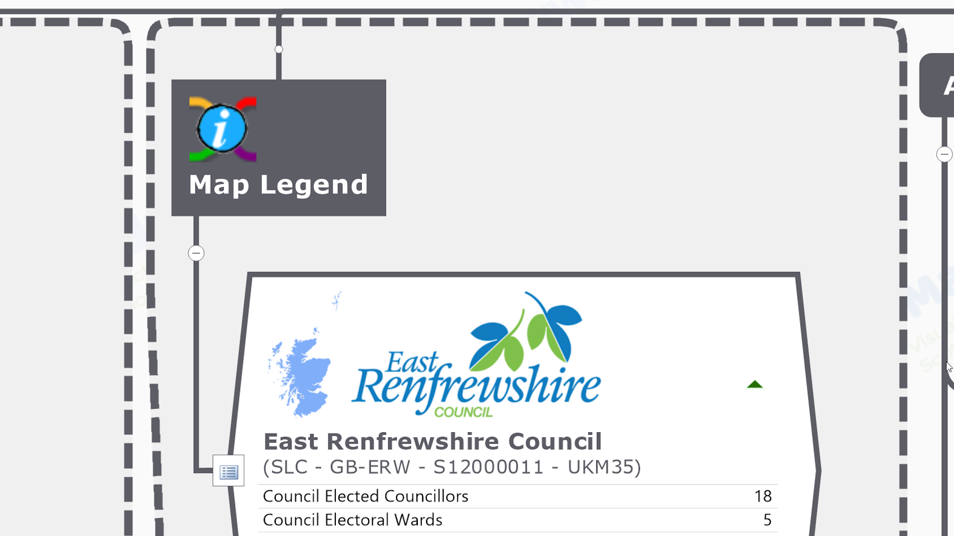
No map is complete without a legend – the bit that explains about the different elements that go to make it up. The Map Legend branch describes all the knowledge content embedded in, and attached to, each of the different seed branches, including links to further contextual knowledge resources. There is a certain amount of cross-over with the ‘Contributing Knowledge bases’ branch.
So now we have our visually structured index maps of ‘all the important things of a particular type in Scotland as well as all the official / definitive / plain old useful knowledge resources about them’, we need to share them with as many people, organisations, communities and projects as possible. How do we do that?
Well great though MindManager software is, not everybody has it installed on their devices so they can amend, adapt & repurpose – as well as just view – the maps in original (.mmap) file format. However it does have another unique trick up it’s sleeve upon which the ScotlandTheMap project is entirely reliant.
MindManager is the only information mapping software that can also publish it’s maps as HTML5 files.

So what’s the big deal about maps as HTML files? Well they’re…
Just about the same as the original – HTML versions of knowledge maps retain all the rich, visual content – and just about all the functional interactivity – of the original MindManager map. It’s also continually being developed. For example HTML maps can now be visually filtered using the index marker tags attached to branches.
But a bit bigger – The file size of the HTML version of the map is about 40 – 50% bigger than the original MindManager (.mmap) file, depending on the type of content (the presence of lots of images is really what bumps up the file size no matter which file format).
Easily Viewed – Just as importantly HTML map files can be viewed…
- In any modern web browser software – Which is basically all of them – Mozilla Firefox, Google Chrome, Apple Safari, Microsoft Edge etc…
- On any device – Desktop computers, tablets and smart phones (all of which come with browsers pre-installed!)
- Without the need for any software plugins – No need for additional bits of software to be downloaded and installed on your device in order to open and view your file properly,
- As standalone files or embedded in web pages – The .html file can be viewed as you would any other file downloaded from the web or file sharing service (eg. Dropbox), or sent as an email attachment – by double clicking on it on the device. However like a Google Map it can also be embedded within a frame on a web page and viewed without the viewer consciously downloading anything (the file still has to be physically ‘hosted’ on a server somewhere and ‘served’ to the page when viewed). An example would be our ‘map of maps’ is embedded in the footer of every page of this website.
- On-, or off-, line – Once the file – or the web page in which its is embedded – has downloaded to the device, there is no need for an internet connection in order for it to be viewed and interacted with. Obviously a connection is required to view the online knowledge resources linked to in the map, but the contextual knowledge contained in the seed branches of the map itself will be available.
So now we’ve got the easily viewable and shareable HTML version of our knowledge map, we can make it available to the world on the StM project website…
For Free – As noted in the ‘benefits of StM for us‘ section below, we want to give something back to the dedicated professionals & volunteers that need to use the knowledge resources in our maps in order to do what they need to do, and also the information professionals that produce them in the first place. Making the HTML maps available for free is our way of giving back to Scotland.
Published ‘In’ Blog Posts – Because the whole idea of knowledge maps will be unfamiliar to most, we want to include lots of descriptive information about each map as well as the ability to view and download it. This lends itself more to a blog site with file download capability, as opposed to a store setup where files have to be added to carts and then ‘purchased’ (even though they’re free) before they can even be viewed, let alone downloaded.

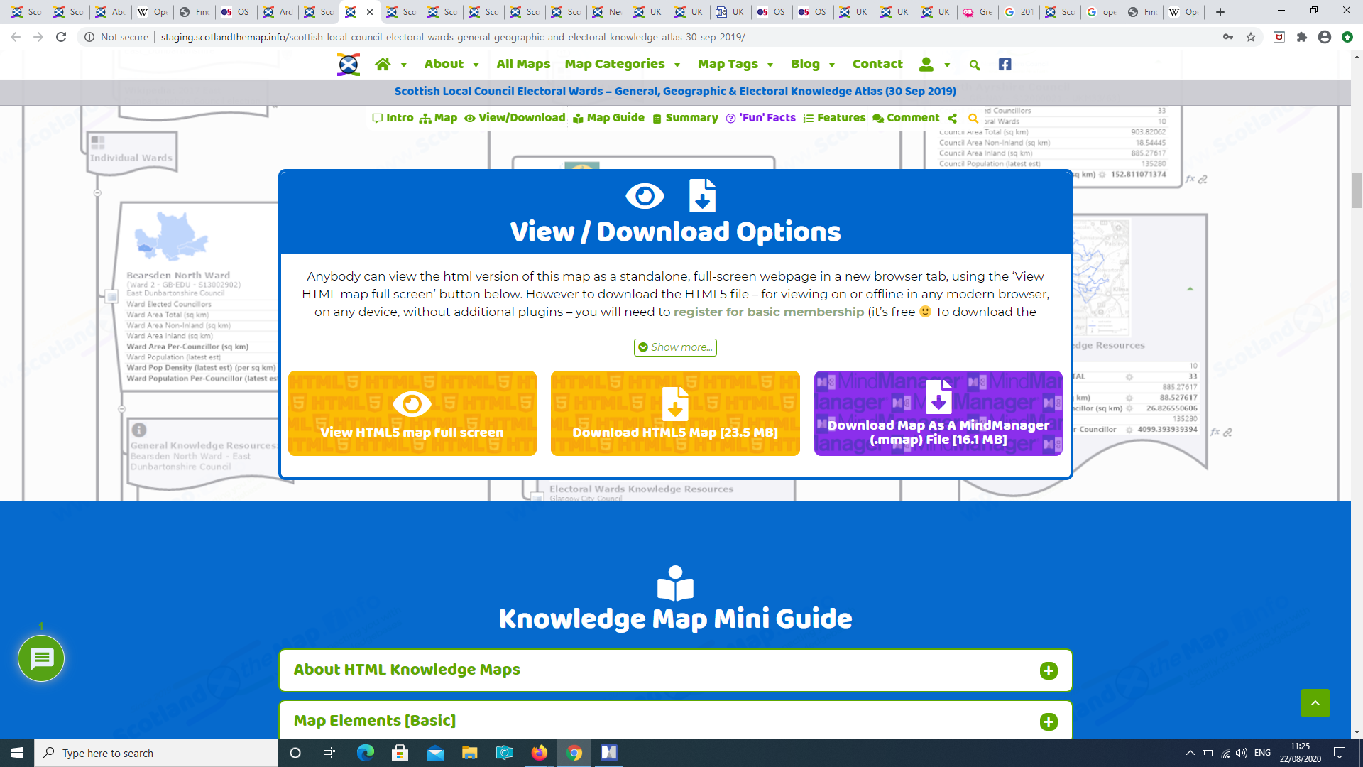
Viewing The HTML Maps – As mentioned already HTML maps can be embedded in a frame within the body of a web page, just like a Google Map (as per our ‘map of maps’ is embedded in the footer of every page of this website). We experimented with embedding the maps wthin the blog post page at the start of the project, however we decided it was ‘a bit too much’ visual overload, as well as big map files appreciably slowing down the loading time for the whole page. Thus we have now opted for a ‘view fullscreen’ button instead so the map file opens as a standalone page in a new browser tab after the user clicks it when they’re ready to explore.

Downloading The HTML Map File – Though downloading the HTML5 file is also free, users will need to register for basic ScotlandTheMap membership, first. This is free  , and only requires minimal details to set up the account.
So making the HTML version of our maps freely available to view and download from our website ensures that everybody has access to a visually structured index of all the important building blocks of a particular type in Scotland as well as all the official / definitive / plain old useful knowledge resources about them.
But what about those professionals (and dedicated amatuers) that need to build on that knowledge in order to ‘do what they do’ – strategically plan & operationally deliver the activities and services of their organisations, projects and communities? For them our knowledge maps are only the starting point. They will want to amend, adapt & repurpose the content – in whole or in part – to build their own maps, using their own copy of MindManager (or other) information mapping software.

So to support those that want to take it to the next level, we also make the map files available to download in the original MindManager (.mmap) file format on the website. We do this through a further tier of PRO membership, with a modest annual, or one off lifetime, membership fee to help support the project.
Our Scottish Local councils – General & Geographic Knowledge Atlas is the ideal starting point for ‘thumb & brain friendly’ desktop (or even ‘in the field’) research for anyone with an interest in any, or all, of Scotland’s 32 Local Councils. It is made up of a visual framework of…
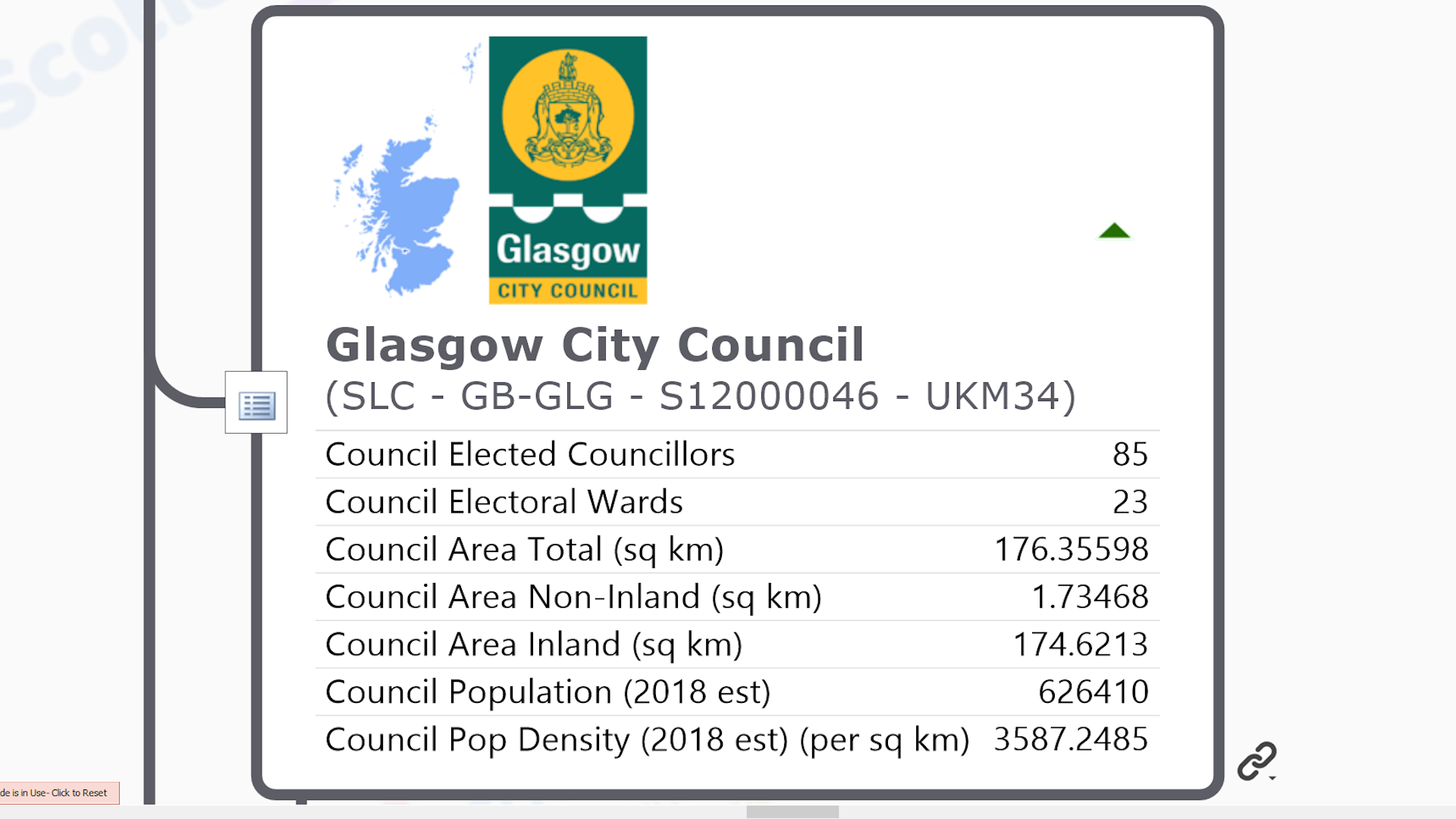
![]() 32 Scottish Local Council general knowledge seed branches – with unique identifying codes, embedded logo & thumbnail location map image and contextual general ‘facts & figures such as geographic area and population as single data fields, as well as attached multiple hyperlinks to core general & geographic knowledge resources, and index markers that also tag them with some of the contextual knowledge.
32 Scottish Local Council general knowledge seed branches – with unique identifying codes, embedded logo & thumbnail location map image and contextual general ‘facts & figures such as geographic area and population as single data fields, as well as attached multiple hyperlinks to core general & geographic knowledge resources, and index markers that also tag them with some of the contextual knowledge.
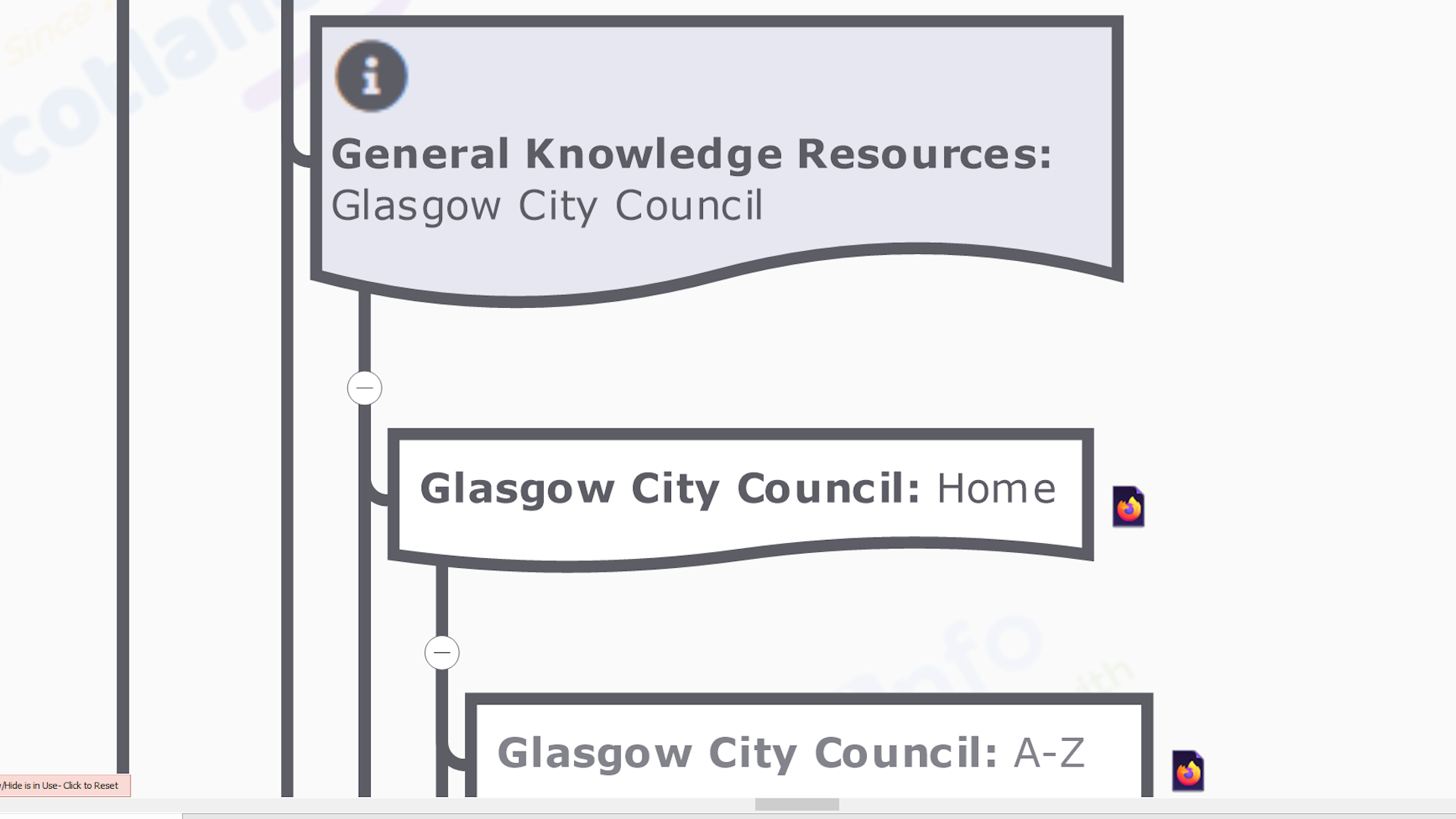
Each of these seed branches also has collections of sub-branches, each with a single hyperlink to official / definitive / plain old useful General or Geographic knowledge resources about the Council found in the public domian…
![]() General Knowledge Resource Link Collection – This includes the local council’s website home, A-Z of services and councillors pages, profiles by the Convention of Scottish Local Authorities (COSLA), the National Records of Scotland and the Scottish Index of Multiple Deprivation, and Wikipedia Articles on the council and geographic area administered by the council.
General Knowledge Resource Link Collection – This includes the local council’s website home, A-Z of services and councillors pages, profiles by the Convention of Scottish Local Authorities (COSLA), the National Records of Scotland and the Scottish Index of Multiple Deprivation, and Wikipedia Articles on the council and geographic area administered by the council.
![]() Geographic Knowledge Resource Link Collection – This includes the local council’s website mapping pages (if they have them), their entry in the Gazetteer for Scotland, the Local Government Boundary Commission for Scotland Council Area Overview Map, the various current & historical online map viewers from the National Library of Scotland, global online mapping services like Google Maps & Open Street Map, and the Wikipedia List of articles about places in the Council Area.
Geographic Knowledge Resource Link Collection – This includes the local council’s website mapping pages (if they have them), their entry in the Gazetteer for Scotland, the Local Government Boundary Commission for Scotland Council Area Overview Map, the various current & historical online map viewers from the National Library of Scotland, global online mapping services like Google Maps & Open Street Map, and the Wikipedia List of articles about places in the Council Area.
![]() MindManager Users – As with all our maps, the MindManager (.mmap) version of this map is also both a base map to add your own content to, or a source of content that can be added to your own existing maps.
MindManager Users – As with all our maps, the MindManager (.mmap) version of this map is also both a base map to add your own content to, or a source of content that can be added to your own existing maps.


Angus McDonald
Connect with me...